Merton, Norfolk
| Merton | |
 Merton St Peter |
|
 Merton |
|
| Area | 5.94 km2 (2.29 sq mi) |
|---|---|
| Population | 133 (2011)[1] |
| – density | 22/km2 (57/sq mi) |
| OS grid reference | TL907988 |
| Civil parish | Merton |
| District | Breckland |
| Shire county | Norfolk |
| Region | East |
| Country | England |
| Sovereign state | United Kingdom |
| Post town | THETFORD |
| Postcode district | IP25 |
| Police | Norfolk |
| Fire | Norfolk |
| Ambulance | East of England |
| EU Parliament | East of England |
Coordinates: 52°33′14″N 0°48′42″E / 52.554°N 0.8116°E
Merton is a civil parish in the English county of Norfolk. It covers an area of 5.94 km2 (2.29 sq mi) and had a population of 113 in 50 households at the 2001 census,[2] increasing to a population 0f 133 in 56 househods at the 2011 census. For the purposes of local government, it falls within the district of Breckland.
Merton Hall is the home of Lord Walsingham
Its church, St Peter's, is one of 124 existing round-tower churches in Norfolk and is a grade I listed building.[3]
Notes
- ↑ "Civil Parish population 2011". Neighbourhood Statistics. Office for National Statistics. Retrieved 8 August 2016.
- ↑ Census population and household counts for unparished urban areas and all parishes. Office for National Statistics & Norfolk County Council (2001). Retrieved 20 June 2009.
- ↑ "Name: CHURCH OF ST. PETER List entry Number: 1172419". English Heritage. Retrieved 9 March 2014.
External links
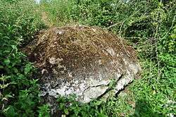
The Merton Stone, glacial erratic
| Wikimedia Commons has media related to Merton, Norfolk. |
| Boroughs or districts | |
|---|---|
| Major settlements |
|
| Topics | |
This article is issued from Wikipedia - version of the 10/12/2016. The text is available under the Creative Commons Attribution/Share Alike but additional terms may apply for the media files.