Thunder Basin National Grassland
| Thunder Basin National Grassland | |
|---|---|
|
IUCN category VI (protected area with sustainable use of natural resources) | |
|
Thunder Basin National Grassland | |
 | |
| Location | Wyoming, United States |
| Nearest city | Gillette, WY |
| Coordinates | 43°41′N 105°01′W / 43.68°N 105.02°W[1]Coordinates: 43°41′N 105°01′W / 43.68°N 105.02°W[2] |
| Area | 547,499 acres (221,565 ha)[3] |
| Established | June 23, 1960 |
| Governing body | U.S. Forest Service |
| Website | Medicine Bow-Routt National Forests & Thunder Basin National Grassland |
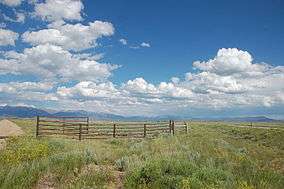
The Thunder Basin National Grassland is located in northeastern Wyoming in the Powder River Basin between the Big Horn Mountains and the Black Hills. The Grassland ranges in elevation from 3,600 feet (1,100 m) to 5,200 feet (1,600 m), and the climate is semi-arid. The Grassland provides opportunities for recreation, including hiking, sightseeing, hunting, and fishing. There are no developed campgrounds; however, camping is allowed. The Grassland abounds with wildlife year-round, provides forage for livestock, and is underlain with vast mineral resources. Land patterns are very complex because of the intermingled federal, state, and private lands.[4]
In descending order of land area, it is located in parts of Weston, Converse, Campbell, Niobrara, and Crook counties. It is managed together with Medicine Bow - Routt National Forest from Forest Service offices in Laramie, Wyoming; its local ranger district office is in Douglas.[4]
References
- ↑ "Thunder Basin National Grassland". Geographic Names Information System. United States Geological Survey. Retrieved December 9, 2012.
- ↑ "Thunder Basin National Grassland". Geographic Names Information System. United States Geological Survey. Retrieved December 9, 2012.
- ↑ "Land Areas of the National Forest System". U.S. Forest Service. January 2013. Retrieved December 9, 2012.
- 1 2 "Medicine Bow-Routt National Forest & Thunder Basin National Grassland". U.S. Forest Service. Retrieved December 9, 2012.
External links
 Media related to Thunder Basin National Grassland at Wikimedia Commons
- Medicine Bow-Routt National Forests & Thunder Basin National Grassland - U.S. Forest Service