Mayapa
| Mayapa Barangay ng Mayapa, Lungsod ng Calamba (San Jose) | |
|---|---|
| Urbanized Barangay | |
|
A Canlubang-Mayapa SLEX exit traffic | |
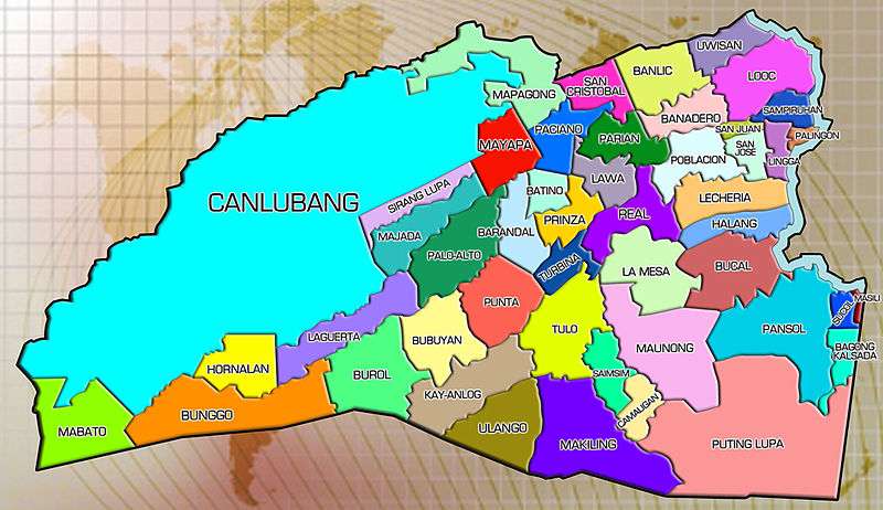 Map of Calamba City showing the location of the barangays | |
| Coordinates: 14°12′37″N 121°7′22″E / 14.21028°N 121.12278°ECoordinates: 14°12′37″N 121°7′22″E / 14.21028°N 121.12278°E | |
| Country | Philippines |
| Philippines | Laguna |
| region | CALABARZON (Region IV-A) |
| City | Calamba City |
| Government | |
| • Chairman | Flaviano C. Taniola |
| • Councilors |
|
| Area | |
| • Land | 116.3 km2 (44.9 sq mi) |

Mayapa, also known as Campo, is now an urban barangay, located to the east of the Sirang Lupa and southeast of the Canlubang in Calamba City, Laguna, Philippines. This barangay is situated to the north shore edge of the city and is next to the Canlubang exit (Exit 47) of the South Luzon Expressway.
Barangay Mayapa have a independent compound, known as Camp Vicente Lim, located at Mayapa Road. Camp Vicente LIm is beside Ceris III Village, Canlubang.
Geography
Neighboring Barangays:
- West-Canlubang, Sirang Lupa, Majada Out
- East- Paciano
- South- Palo Alto, Barandal, Batino
- North- Canlubang
Camp Vicente Lim
| Camp Vicente Lim | |
|---|---|
| Compound | |
| Region | CALABARZON (Region IV-A) |
| Philippines | Laguna |
| City | Calamba City |
Camp Vicente Lim is a campus of the police training in the CALABARZON region located at Barangay Mayapa, Camp Vicente Lim's Zip code 4029. The rest of Barangay Mayapa uses the Calamba, Laguna zip code 4027.
Sitios, puroks and villages
Barangay Mayapa is subdivided into sitios, puroks and villages inside the barangay. These include:
- Mayapa Proper
- St. Savio
- San Lorenzo
- Torres Compound
- Maryland Compound
- Calamba Hills Village I
- Don Bosco
- Visaya Compound
- St. Christopher II Village
- St. Christopher II Annex
- Doctora's Compound
- Sto. Niño
- Camp Vicente Lim (Purok 1-6)
Camp Vicente Lim Zip Code
- 4029
Population
- 2010 - 21,826
- 2007 - 21,968
- 2000 - 18,379
- 1995 - 17,412
- 1990 - 13,258
- 1980 - 7,545
Geography
Location:
- Mayapa, Calamba City
 |
Canlubang/Mapagong | | ||
| Sirang Lupa, Palo-Alto, Majada Out | |
Paciano Rizal | ||
| ||||
| | ||||
| Barandal/Batino |
References
External links
| Geography | |||||||||||
|---|---|---|---|---|---|---|---|---|---|---|---|
| City |
| ||||||||||
| Officials | |||||||||||
| History |
| ||||||||||
| Barangays |
| ||||||||||
| Sister Cities | |||||||||||
| Notable people | |||||||||||