Marvyn, Alabama
| Marvyn | |
|---|---|
| Unincorporated community | |
|
Marvyn's abandoned service station located at the intersection of Alabama Highway 51 and U.S. Highway 80. | |
 Marvyn  Marvyn Location within the state of Alabama | |
| Coordinates: 32°26′21″N 85°21′51″W / 32.43917°N 85.36417°WCoordinates: 32°26′21″N 85°21′51″W / 32.43917°N 85.36417°W | |
| Country | United States |
| State | Alabama |
| County | Lee |
| Elevation | 499 ft (152 m) |
| Time zone | CST (UTC-6) |
| • Summer (DST) | EDT (UTC-6) |
| GNIS feature ID | 122351[1] |

Marvyn, also spelled Marvin, is an unincorporated community southerly located in Lee County, Alabama, United States. It sits at the crossroads of Alabama Highway 51 and U.S. Highway 80, and in the Lee County "panhandle" between Russell County and Macon County. It is part of the Columbus, Georgia-Alabama Metropolitan Area.
History
Marvyn was originally located in Russell County, but was granted to Lee County in 1923 in exchange for Phenix City. A soil series is named after Marvyn, as it was first described in the area. The Marvyn soil series is described as a "fine-loamy, siliceous, thermic Typic Hapludults.[2]
Demographics
| Historical population | |||
|---|---|---|---|
| Census | Pop. | %± | |
| 1880 | 241 | — | |
| U.S. Decennial Census[3] | |||
Marvyn appeared on the U.S. Census in 1880 with a population of 241 residents. At the time it was located in Russell County. This was the only time it was listed on the census rolls as a separate community.
References
- ↑ U.S. Geological Survey Geographic Names Information System: Marvyn, Alabama
- ↑ Claude E. Boyd (31 July 1995). Bottom Soils, Sediment, and Pond Aquaculture. Springer Science & Business Media. p. 56. ISBN 978-0-412-06941-3.
- ↑ "U.S. Decennial Census". Census.gov. Archived from the original on May 11, 2015. Retrieved June 6, 2013.
- Barnes, Margaret Anne (1998). The Tragedy and the Triumph of Phenix City, Alabama. Macon, Ga., Mercer University Press. ISBN 0-86554-613-4
External links
Municipalities and communities of Lee County, Alabama, United States | ||
|---|---|---|
| Cities | 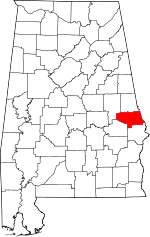 | |
| Towns | ||
| Unincorporated communities | ||
| Footnotes | ‡This populated place also has portions in an adjacent county or counties | |
| Central cities/Largest cities | 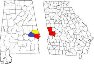 Location of the Columbus, Georgia-Auburn, Alabama CSA and its counties:
Columbus, Georgia Metropolitan Statistical Area
Auburn, Alabama Metropolitan Statistical Area
Tuskegee, Alabama Micropolitan Statistical Area (defunct) | |
|---|---|---|
| Cities in Georgia | ||
| Cities in Alabama | ||
| Counties in Georgia | ||
| Counties in Alabama | ||