Buena Vista, Georgia
| Buena Vista, Georgia | |
|---|---|
| City | |
|
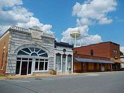
Buena Vista in 2012. | |
 Location in Marion County and the state of Georgia | |
| Coordinates: 32°19′6″N 84°30′58″W / 32.31833°N 84.51611°WCoordinates: 32°19′6″N 84°30′58″W / 32.31833°N 84.51611°W | |
| Country | United States |
| State | Georgia |
| County | Marion |
| Area | |
| • Total | 3.2 sq mi (8.5 km2) |
| • Land | 3.2 sq mi (8.4 km2) |
| • Water | 0 sq mi (0.1 km2) |
| Elevation | 719 ft (219 m) |
| Population (2000) | |
| • Total | 1,664 |
| • Density | 520/sq mi (195.8/km2) |
| Time zone | Eastern (EST) (UTC-5) |
| • Summer (DST) | EDT (UTC-4) |
| ZIP code | 31803 |
| Area code(s) | 229 |
| FIPS code | 13-11728[1] |
| GNIS feature ID | 0354903[2] |
Buena Vista (pronounced "BYOO-nah VIHS-tah") is a city in Marion County, Georgia, United States. It is part of the Columbus, Georgia-Alabama Metropolitan Statistical Area. The population was 1,664 at the 2000 census. Formerly known as Pea Ridge, the city changed its name to Buena Vista in honor of Zachary Taylor's victory in the Mexican American War.[3] The city is the county seat of Marion County.[4] It is the birthplace of baseball legend, Josh Gibson and Medal of Honor recipient Luther H. Story. The visionary art site Pasaquan is located four miles (6 km) from Buena Vista, in rural Marion County.
History
Buena Vista was founded in 1830. In 1850, the seat of Marion County was transferred to Buena Vista from Tazewell. Buena Vista was incorporated as a town in 1850 and as a city in 1920.[5]
Geography
Buena Vista is located at 32°19′6″N 84°30′58″W / 32.31833°N 84.51611°W (32.318301, -84.516035).[6]
According to the United States Census Bureau, the city has a total area of 3.3 square miles (8.5 km2), of which, 3.2 square miles (8.3 km2) of it is land and 0.04 square miles (0.10 km2) of it (0.91%) is water.
Demographics
| Historical population | |||
|---|---|---|---|
| Census | Pop. | %± | |
| 1850 | 530 | — | |
| 1870 | 525 | — | |
| 1880 | 529 | 0.8% | |
| 1890 | 788 | 49.0% | |
| 1900 | 1,161 | 47.3% | |
| 1910 | 1,016 | −12.5% | |
| 1920 | 1,230 | 21.1% | |
| 1930 | 1,097 | −10.8% | |
| 1940 | 1,161 | 5.8% | |
| 1950 | 1,428 | 23.0% | |
| 1960 | 1,574 | 10.2% | |
| 1970 | 1,486 | −5.6% | |
| 1980 | 1,544 | 3.9% | |
| 1990 | 1,472 | −4.7% | |
| 2000 | 1,664 | 13.0% | |
| 2010 | 2,173 | 30.6% | |
| Est. 2015 | 2,206 | [7] | 1.5% |
As of the census[1] of 2000, there were 1,664 people, 645 households, and 377 families residing in the city. The population density was 512.9 people per square mile (198.3/km²). There were 756 housing units at an average density of 233.0 per square mile (90.1/km²). The racial makeup of the city was 63.40% African American, 25.84% White, 0.18% Native American, 0.36% Asian, 0.30% Pacific Islander, 8.59% from other races, and 1.32% from two or more races. Hispanic or Latino of any race were 17.91% of the population.
There were 645 households out of which 32.2% had children under the age of 18 living with them, 25.4% were married couples living together, 26.5% had a female householder with no husband present, and 41.4% were non-families. 35.0% of all households were made up of individuals and 16.1% had someone living alone who was 65 years of age or older. The average household size was 2.55 and the average family size was 3.23.
In the city the population was spread out with 30.0% under the age of 18, 13.0% from 18 to 24, 27.3% from 25 to 44, 16.8% from 45 to 64, and 12.9% who were 65 years of age or older. The median age was 30 years. For every 100 females there were 101.2 males. For every 100 females age 18 and over, there were 95.8 males.
The median income for a household in the city was $17,672, and the median income for a family was $21,738. Males had a median income of $19,306 versus $17,017 for females. The per capita income for the city was $11,406. About 28.6% of families and 34.7% of the population were below the poverty line, including 43.3% of those under age 18 and 32.1% of those age 65 or over.
Education
Marion County School District
The Marion County School District holds pre-school to grade twelve, and consists of one primary school (grades: pre-k through 5th) and a middle/high school (grades: 6th-12th).[9] The district has 108 full-time teachers and over 1,686 students.[10]
- L. K. Moss Primary School
- Marion County Middle High School—www.marion.k12.ga.us
The Marion County School District is in the process of opening a new middle/high school. The 146,000-square-foot (13,600 m2) structure will sit on 200 acres of land in the middle of the county and is scheduled to open for the 2012-13 school year.
Notable people
- Josh Gibson - Negro Leagues baseball player and Hall of Famer
- Roosevelt Jackson - oldest living Negro Leagues baseball player[11]
- Eddie Owens Martin - creator of Pasaquan.
Gallery
-
_Buena_Vista%2C_GA.JPG)
The Marion County Courthouse is located in Buena Vista. It was added to the National Register of Historic Places on September 18, 1980.
-

Buena Vista City Hall
-
.JPG)
Buena Vista Post Office (ZIP code: 31803)
-
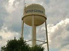
A water tower in Buena Vista proudly proclaims the town to be the "Home of Josh Gibson". The Hall of Famer was born in Buena Vista on December 21, 1911.
-
_Buena_Vista%2C_GA.JPG)
"Pasaquan" is a seven-acre compound near Buena Vista created by outsider artist, Eddie Owens Martin (1908-1986), known as "St. EOM". The site is maintained by the Pasaquan Preservation Society. It was added to the National Register of Historic Places on August 27, 2008.
-
_Buena_Vista%2C_GA.JPG)
The Shiloh-Marion Baptist Church and Cemetery, located just south of Buena Vista near the Webster County line, was added to the National Register of Historic Places on May 17, 1984.
-
_Buena_Vista%2C_GA.JPG)
The Drane-Stevens House, located in Buena Vista, was added to the National Register of Historic Places on July 28, 1999.
-
_Buena_Vista%2C_GA.JPG)
The Alfred and Jane Ables House, located in Buena Vista, was added to the National Register of Historic Places on August 9, 2002.

References
- 1 2 "American FactFinder". United States Census Bureau. Archived from the original on 2013-09-11. Retrieved 2008-01-31.
- ↑ "US Board on Geographic Names". United States Geological Survey. 2007-10-25. Retrieved 2008-01-31.
- ↑ New Georgia Encyclopedia, retrieved 20 Aug 2012.
- ↑ "Find a County". National Association of Counties. Archived from the original on 2011-05-31. Retrieved 2011-06-07.
- ↑ Hellmann, Paul T. (May 13, 2013). Historical Gazetteer of the United States. Routledge. p. 221. Retrieved 30 November 2013.
- ↑ "US Gazetteer files: 2010, 2000, and 1990". United States Census Bureau. 2011-02-12. Retrieved 2011-04-23.
- ↑ "Annual Estimates of the Resident Population for Incorporated Places: April 1, 2010 to July 1, 2015". Retrieved July 2, 2016.
- ↑ "Census of Population and Housing". Census.gov. Archived from the original on May 11, 2015. Retrieved June 4, 2015.
- ↑ Georgia Board of Education, Retrieved June 23, 2010.
- ↑ School Stats, Retrieved June 23, 2010.
- ↑ "Oldest Living Member of the Negro Leagues Honored". Waterloo Cedar Falls Courier. July 24, 2011.
Municipalities and communities of Marion County, Georgia, United States | ||
|---|---|---|
| City | 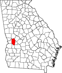 | |
| Unincorporated community | ||
| Central cities/Largest cities | 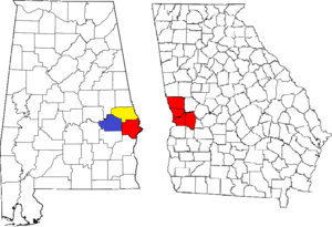 Location of the Columbus, Georgia-Auburn, Alabama CSA and its counties:
Columbus, Georgia Metropolitan Statistical Area
Auburn, Alabama Metropolitan Statistical Area
Tuskegee, Alabama Micropolitan Statistical Area (defunct) | |
|---|---|---|
| Cities in Georgia | ||
| Cities in Alabama | ||
| Counties in Georgia | ||
| Counties in Alabama | ||