March Route of Rochambeau's Army: Palmer Road
|
March Route of Rochambeau's Army: Palmer Road | |
|
Palmer Road in 2016 | |
  | |
| Location | Palmer Rd, from intersection with Miller Rd. to E of jct. with Pudding Hill Rd., Scotland, Connecticut |
|---|---|
| Coordinates | 41°41′57″N 72°3′47″W / 41.69917°N 72.06306°WCoordinates: 41°41′57″N 72°3′47″W / 41.69917°N 72.06306°W |
| Area | 2.6 acres (1.1 ha) |
| MPS | Rochambeau's Army in Connecticut, 1780-1782 MPS |
| NRHP Reference # | 03000311[1] |
| Significant dates | |
| Dates of significance | 1781, 1782 |
| Added to NRHP | June 6, 2003 |
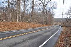
March Route of Rochambeau's Army: Palmer Road is a linear historic district running about 2,000 feet (610 m) along Palmer Road (Connecticut Route 14) from its intersection with Miller Road east to a point 800 feet from the junction with Pudding Hill Road in Scotland, Connecticut. It was listed on the National Register of Historic Places in 2003.[1]

It is along the march route taken by French commander Rochambeau's troops in 1781 and again during their return march in 1782. It was a narrow, steep, stony road then. Now, it has expansive views of farmland.[2]
The French troops, with artillery and wagons, reportedly found the marching difficult in this segment, though easier after the included hill. It was reportedly viewed by the French as "a narrow, steep, and stony road" in this segment (per Rice and Brown, 1972, p. 23, cited in NRHP document).[2]
The modern road is paved, but the hilly, winding nature of the road, and remnants of stone walls, and other elements evoke the experience of the French troops in this section.[2]
To the east about 3 miles (4.8 km) along Route 14 is March Route of Rochambeau's Army: Manship Road-Barstow Road, another preserved section of the march route, a 1,400 feet (430 m) stretch along a bypass of Route 14. Multiple other properties whose association with Rochambeau's route is known were also considered for listing on the National Register in a study.[3]
See also
References
- 1 2 National Park Service (2009-03-13). "National Register Information System". National Register of Historic Places. National Park Service.
- 1 2 3 Mary Harper and Bruce Clouette (April 30, 2001). "National Register of Historic Places Registration: March Route of Rochambeau's Army: Palmer Road" (PDF). National Park Service. and Accompanying six photos
- ↑ Bruce Clouette and Mary Harper (October 22, 2001). "National Register of Historic Places Multiple Property Documentation: Rochambeau's Army in Connecticut, 1780-1782 MPS" (PDF). National Park Service.

| Topics | |
|---|---|
| Lists by states |
|
| Lists by insular areas | |
| Lists by associated states | |
| Other areas | |
| |