Manasota Key, Florida
| Manasota Key, Florida Englewood Beach | |
|---|---|
| Census-designated place | |
 Location in Charlotte County and the state of Florida | |
| Coordinates: 26°56′N 82°22′W / 26.933°N 82.367°WCoordinates: 26°56′N 82°22′W / 26.933°N 82.367°W | |
| Country | United States |
| State | Florida |
| County | Charlotte |
| Area | |
| • Total | 3.1 sq mi (8.0 km2) |
| • Land | 1.0 sq mi (2.7 km2) |
| • Water | 2.0 sq mi (5.2 km2) |
| Elevation | 0 ft (0 m) |
| Population (2010) | |
| • Total | 1,229 |
| • Density | 1,176/sq mi (454.0/km2) |
| Time zone | Eastern (EST) (UTC-5) |
| • Summer (DST) | EDT (UTC-4) |
| FIPS code | 12-42750[1] |
| GNIS feature ID | 1867173[2] |
Manasota Key is a census-designated place (CDP) consisting mainly of the community of Englewood Beach in Charlotte County, Florida, United States. The population of the CDP was 1,229 at the 2010 census.[3] It is part of the Punta Gorda Metropolitan Statistical Area.
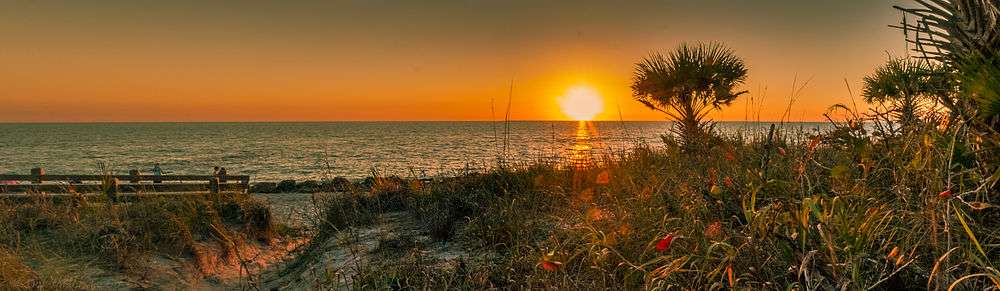
The name "Manasota Key" refers to an 11-mile-long (18 km) peninsula (transformed into a barrier island by the Gulf Intracoastal Waterway) that continues north into Sarasota County. The community of Englewood Beach occupies the Charlotte County portion of the key, while the Sarasota County part of the peninsula contains the community of Manasota Beach. The key continues north as Caspersen Beach, extending as far as the Venice city limits.
Geography
The Manasota Key CDP is located in the northwestern corner of Charlotte County at 26°56′N 82°22′W / 26.933°N 82.367°W (26.9260, -82.3596).[4] As noted above, the barrier island of the same name extends north well into Sarasota County. Its western edge is the Gulf of Mexico, and to the east is Lemon Bay, an estuary. The community of Englewood Beach occupies most of the CDP, and it is connected to the mainland by Beach Road, which crosses Lemon Bay to Englewood. The southern end of the CDP, which includes Manasota Key, Peterson Island, and Whidden Key, is covered by Stump Pass Beach State Park. Stump Pass is a channel that connects Lemon Bay to the Gulf of Mexico and separates Manasota Key from Don Pedro Island to the south. Grove City is located directly to the east across Lemon Bay from the south end of Manasota Key.
According to the United States Census Bureau, the CDP has a total area of 3.1 square miles (8.0 km2), of which 1.0 square mile (2.7 km2) is land and 2.0 square miles (5.2 km2), or 65.97%, is water.[3]
Demographics
As of the census[1] of 2000, there were 1,345 people, 769 households, and 459 families residing in the CDP. The population density was 1,263.2 people per square mile (489.9/km²). There were 1,867 housing units at an average density of 1,753.4/sq mi (680.0/km²). The racial makeup of the CDP was 99.26% White, 0.15% African American, 0.30% Asian, 0.22% from other races, and 0.07% from two or more races. Hispanic or Latino of any race were 0.97% of the population.
Englewood Beach
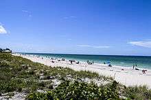
Englewood Beach (previously known as Chadwick Beach) occupies the Charlotte County part of Manasota Key, connected to Englewood by Beach Road. It is a popular attraction for visitors to the area, particularly during the "spring break" period. During the winter months, many part-time residents of the area return from northern states to their winter homes (referred to by locals as "snowbirds").
There are limited paid parking facilities located by the beach. From 9:00 AM until 4:00 PM parking fees are 75 cents per hour. There are restrooms, showers and picnic tables available for public use, with commercial eating establishments within a short walk.
In January, the average daily temperature is in the mid to low 60's Fahrenheit. The average daily summer temperatures are in the low to mid 90's Fahrenheit.
The now extinct Chadwick Beach cotton mouse was endemic to the Englewood Beach area.
Notable people
- Tim McGraw, country singer; reportedly purchased a waterfront mansion here
- Donna Summer, singer and songwriter; lived, and died, on Manasota Key
- Bobby Vinton, pop singer; has an estate on the Sarasota County portion of Manasota Key
Demographics
There were 769 households out of which 3.5% had children under the age of 18 living with them, 57.0% were married couples living together, 2.2% had a female householder with no husband present, and 40.3% were non-families. 35.9% of all households were made up of individuals and 23.7% had someone living alone who was 65 years of age or older. The average household size was 1.75 and the average family size was 2.16.
In the CDP the population was spread out with 3.9% under the age of 18, 1.1% from 18 to 24, 8.1% from 25 to 44, 32.5% from 45 to 64, and 54.4% who were 65 years of age or older. The median age was 67 years. For every 100 females there were 83.0 males. For every 100 females age 18 and over, there were 82.1 males.
The median income for a household in the CDP was $44,071, and the median income for a family was $57,059. Males had a median income of $58,750 versus $36,607 for females. The per capita income for the CDP was $40,759. None of the families and 4.7% of the population were living below the poverty line, including no under eighteens and 6.1% of those over 64.
References
- 1 2 "American FactFinder". United States Census Bureau. Retrieved 2008-01-31.
- ↑ "US Board on Geographic Names". United States Geological Survey. 2007-10-25. Retrieved 2008-01-31.
- 1 2 "Geographic Identifiers: 2010 Demographic Profile Data (G001): Manasota Key CDP, Florida". U.S. Census Bureau, American Factfinder. Retrieved June 25, 2014.
- ↑ "US Gazetteer files: 2010, 2000, and 1990". United States Census Bureau. 2011-02-12. Retrieved 2011-04-23.
Municipalities and communities of Charlotte County, Florida, United States | ||
|---|---|---|
| City | 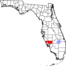 | |
| CDPs | ||
| Unincorporated communities | ||
| Footnotes | ‡This populated place also has portions in an adjacent county or counties | |