Loxton, Northern Cape
| Loxton | |
|---|---|
|
View of Loxton | |
 Loxton  Loxton  Loxton
| |
| Coordinates: 31°28′S 22°21′E / 31.467°S 22.350°ECoordinates: 31°28′S 22°21′E / 31.467°S 22.350°E | |
| Country | South Africa |
| Province | Northern Cape |
| District | Pixley ka Seme |
| Municipality | Ubuntu |
| Established | 1899 |
| Area[1] | |
| • Total | 77.61 km2 (29.97 sq mi) |
| Population (2011)[1] | |
| • Total | 1,053 |
| • Density | 14/km2 (35/sq mi) |
| Racial makeup (2011)[1] | |
| • Black African | 3.1% |
| • Coloured | 85.4% |
| • Indian/Asian | 0.3% |
| • White | 10.7% |
| • Other | 0.5% |
| First languages (2011)[1] | |
| • Afrikaans | 93.8% |
| • English | 3.6% |
| • Other | 2.6% |
| PO box | 6985 |
| Area code | 053 |
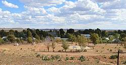
Loxton is a town in the Karoo region of South Africa's Northern Cape province. It is a wool-producing centre in the Ubuntu Local Municipality of the Pixley ka Seme District Municipality and one of the largest garlic-producing areas in South Africa.
The area around Loxton is famous for its beehived shaped Corbelled Houses that were built by Trekboers around the 1810s and are unique to the area.[2] The Dutch Reformed Church bought the farm Phezantefontein from AE Loxton in 1899.[3] The town became a municipality in 1905. In March 1961 there was a setback when a dam burst upstream and destroyed a large portion of the town. In recent years the town has experienced a revival as urbanites have moved to the small town to escape the city.
Notes
- 1 2 3 4 "Main Place Loxton". Census 2011.
- ↑ "Loxton, Upper Karoo". sa-venues.com. Retrieved 7 February 2011.
- ↑ Raper, P.E. (2004). South African Place Names. Jonathan Ball, Jhb & Cape Town. p. 211. ISBN 1-86842-190-2.
External links
| Wikimedia Commons has media related to Loxton, Northern Cape. |
 |
Carnarvon | | ||
| Fraserburg | |
Victoria West | ||
| ||||
| | ||||
| Beaufort West |
Municipalities and communities of Pixley ka Seme District Municipality, Northern Cape | ||
|---|---|---|
District seat: De Aar | ||
| Emthanjeni | .svg.png) | |
| Kareeberg | ||
| Renosterberg | ||
| Siyancuma | ||
| Siyathemba | ||
| Thembelihle | ||
| Ubuntu | ||
| Umsobomvu | ||