Victoria West
| Victoria West Victoria-Wes | ||
|---|---|---|
|
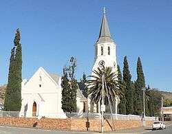
Dutch Reformed Church, Victoria West | ||
| ||
 Victoria West  Victoria West  Victoria West
| ||
| Coordinates: 31°24′11″S 23°07′14″E / 31.40306°S 23.12056°ECoordinates: 31°24′11″S 23°07′14″E / 31.40306°S 23.12056°E | ||
| Country | South Africa | |
| Province | Northern Cape | |
| District | Pixley ka Seme | |
| Municipality | Ubuntu | |
| Established | 1844[1] | |
| Area[2] | ||
| • Total | 78.95 km2 (30.48 sq mi) | |
| Population (2011)[2] | ||
| • Total | 8,254 | |
| • Density | 100/km2 (270/sq mi) | |
| Racial makeup (2011)[2] | ||
| • Black African | 23.7% | |
| • Coloured | 69.3% | |
| • Indian/Asian | 0.4% | |
| • White | 5.6% | |
| • Other | 0.9% | |
| First languages (2011)[2] | ||
| • Afrikaans | 82.1% | |
| • Xhosa | 13.8% | |
| • English | 1.1% | |
| • Other | 3.0% | |
| Postal code (street) | 7070 | |
| PO box | 7070 | |
| Area code | 053 | |

Victoria West is a town in the central Karoo region of South Africa's Northern Cape province.
History
The town was laid out on the bank of the Brakrivier watercourse in 1843,[3] when the Dutch Reformed Church bought the farm Zeekoegat from a local farmer. It was named Victoria in 1844, after Queen Victoria, though amended to Victoria West in 1855 to distinguish it from an Eastern Cape district.[4] The Cape Government Railways oversaw a massive expansion in the Cape Colony's railway system in the 1870s, though the route to Victoria West was only completed in 1881. The railway connection spurred economic development and the town's demographic growth over the following decades.[5]
Government and Infrastructure
It is situated on the main N12 route, at an elevation of 1,300 metres (4,300 ft). It is the seat of the Ubuntu Local Municipality within the Pixley ka Seme District Municipality.[6]
The town has a small airport (ICAO: FAVW), used only by light aircraft, but until the 1970s when they stopped operating piston engined airliners such as the Douglas DC-3, it was a refueling stop for South African Airways between Cape Town and destinations to the north.
See also
References
- ↑ "Chronological order of town establishment in South Africa based on Floyd (1960:20-26)" (PDF). pp. xlv–lii.
- 1 2 3 4 "Main Place Victoria West". Census 2011.
- ↑ Victoria West history, retrieved 2009-02-02
- ↑ Raper, P.E. (2004). South African Place Names. Jonathan Ball, Jhb & Cape Town. p. 211. ISBN 1-86842-190-2.
- ↑ Burman, Jose (1984). Early Railways at the Cape. Cape Town. Human & Rousseau, p.62. ISBN 0-7981-1760-5
- ↑ Victoria West, Heart of the Karoo, retrieved 2009-02-02
| Wikimedia Commons has media related to Victoria West. |
 |
Carnarvon | Vosburg | Britstown | |
| Loxton | |
Richmond | ||
| ||||
| | ||||
| Beaufort West | Nelspoort | Murraysburg |
Municipalities and communities of Pixley ka Seme District Municipality, Northern Cape | ||
|---|---|---|
District seat: De Aar | ||
| Emthanjeni | .svg.png) | |
| Kareeberg | ||
| Renosterberg | ||
| Siyancuma | ||
| Siyathemba | ||
| Thembelihle | ||
| Ubuntu | ||
| Umsobomvu | ||