List of volcanoes in Peru

Chachani and Misti
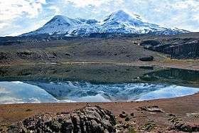
Coropuna

Sabancaya
This is a list of active and extinct volcanoes in Peru.
| Name | Elevation | Location | Last eruption |
| meters | feet | Coordinates |
| Ampato | 6,288 | 20,630 | 15°49′S 71°53′W / 15.817°S 71.883°W / -15.817; -71.883 (Ampato) | - |
| Arichuwa | 5,150 | 16,896 | 16°36′04″S 70°02′00″W / 16.60111°S 70.03333°W / -16.60111; -70.03333 (Arichua) | - |
| Auquihuato | 4,980 | 16,338 | 15°04′S 73°11′W / 15.07°S 73.18°W / -15.07; -73.18 (Auquihuato) | - |
| Chachani | 6,057 | 19,872 | 16°11′28″S 71°31′48″W / 16.191°S 71.530°W / -16.191; -71.530 (Chachani) | Holocene |
| Cerro Nicholson | 2,524 | 8,282 | 16°15′40″S 71°45′14″W / 16.261°S 71.754°W / -16.261; -71.754 (Cerro Nicholson) | Unknown |
| Chilcayoc | 3,347 | 10,981 | 15°31′27″S 72°18′46″W / 15.52417°S 72.31278°W / -15.52417; -72.31278 (Chilcayoc) | - |
| Chilcayoc Grande | 3,243 | 10,640 | 15°32′10″S 72°17′17″W / 15.53611°S 72.28806°W / -15.53611; -72.28806 (Chilcayoc Grande) | - |
| Coropuna[1] | 6,425 | 21,079 | 15°31′S 72°39′W / 15.52°S 72.65°W / -15.52; -72.65 (Coropuna) | Holocene |
| Huambo volcanic field | | | 15°50′S 72°08′W / 15.83°S 72.13°W / -15.83; -72.13 (Huambo volcanic field) | 700 BCE ± 50 |
| Firura | 5,498 | 18,038 | 15°14′S 72°38′W / 15.23°S 72.63°W / -15.23; -72.63 (Firura) | Holocene |
| Jechapita | 3,388 | 11,115 | 15°32′05″S 72°18′39″W / 15.53472°S 72.31083°W / -15.53472; -72.31083 (Jechapita) | - |
| Quinsachata | 3,700 | 12,139 | 14°09′56″S 71°21′21″W / 14.16556°S 71.35583°W / -14.16556; -71.35583 (Quinsachata) | - |
| Misti[2] | 5,822 | 19,101 | 16°17′38″S 71°24′32″W / 16.294°S 71.409°W / -16.294; -71.409 (El Misti) | 1784 |
| Pichu Pichu[3] | 5,564 | 18,255 | 16°26′S 71°14′W / 16.44°S 71.23°W / -16.44; -71.23 (Pichu-Pichu) | - |
| Puca Mauras | 4,955 | 16,257 | 15°27′13″S 72°13′49″W / 15.45361°S 72.23028°W / -15.45361; -72.23028 (Puca Mauras) | - |
| Puca Mauras (Andagua) | 4,262 | 13,983 | 15°25′33″S 72°20′19″W / 15.42583°S 72.33861°W / -15.42583; -72.33861 (Puca Mauras) | - |
| Ccarhuarazo | 5,112 | 16,772 | 14°19′55″S 73°45′25″W / 14.33194°S 73.75694°W / -14.33194; -73.75694 (Ccarhuarazo) | - |
| Jenchaña | 3,600 | 11,800 | 15°31′13″S 72°20′44″W / 15.52028°S 72.34556°W / -15.52028; -72.34556 (Jenchaña) | - |
| Casiri | 5,650 | 18,537 | 17°28′12″S 69°48′47″W / 17.47°S 69.813°W / -17.47; -69.813 (Casiri) | Holocene |
| Sabancaya | 5,967 | 19,577 | 15°47′S 71°51′W / 15.78°S 71.85°W / -15.78; -71.85 (Sabancaya) | 2013 |
| Sara Sara | 5,522 | 18,117 | 15°20′S 73°27′W / 15.33°S 73.45°W / -15.33; -73.45 (Sara Sara) | - |
| Solimana | 6,093 | 19,990 | 15°24′36″S 72°53′35″W / 15.41000°S 72.89306°W / -15.41000; -72.89306 (Solimana) | - |
| Ticsani | 5,408 | 17,743 | 16°45′18″S 70°35′42″W / 16.755°S 70.595°W / -16.755; -70.595 (Ticsani) | - |
| Tutupaca | 5,815 | 19,078 | 17°01′30″S 70°21′29″W / 17.025°S 70.358°W / -17.025; -70.358 (Tutupaca) | - |
| Ticsho | 3,860 | 12,664 | 15°29′05″S 72°22′43″W / 15.48472°S 72.37861°W / -15.48472; -72.37861 (Ticsho) | - |
| Ubinas | 5,672 | 18,609 | 16°21′18″S 70°54′11″W / 16.355°S 70.903°W / -16.355; -70.903 (Ubinas) | 2008 |
| Hualca Hualca | 6,025 | 19,767 | 15°49′S 71°53′W / 15.817°S 71.883°W / -15.817; -71.883 (Hualca Hualca) | - |
| Huaynaputina | 4,850 | 15,912 | 16°36′29″S 70°51′00″W / 16.608°S 70.85°W / -16.608; -70.85 (Huaynaputina) | 1600 |
| Yanamauras | 3,761 | 12,339 | 15°29′02″S 72°21′06″W / 15.48389°S 72.35167°W / -15.48389; -72.35167 (Yanamauras) | - |
| Yucamane | 5,550 | 18,208 | 17°11′S 70°12′W / 17.18°S 70.20°W / -17.18; -70.20 (Yucamane) | 1902 |
Notes
- ↑ Peakware World Mountain Encyclopedia, Coropuna, Retrieved December 27, 2007
- ↑ Peakware World Mountain Encyclopedia, Misti, Retrieved December 27, 2007
- ↑ Peakware World Mountain Encyclopedia, Pikchu Pikchu, Retrieved December 27, 2007
References
- Siebert L, Simkin T (2002-). Volcanoes of the World: an Illustrated Catalog of Holocene Volcanoes and their Eruptions. Smithsonian Institution, Global Volcanism Program Digital Information Series, GVP-3, (http://www.volcano.si.edu).
- John Seach, Volcano Live, Volcanoes of Peru, Retrieved December 27, 2007
- Peakware World Mountain Encyclopedia, Peruvian Andes, Retrieved December 27, 2007
List of volcanoes in South America |
|---|
|
| Sovereign states | |
|---|
|
|
- Falkland Islands
- French Guiana
- South Georgia and the South Sandwich Islands
|
|---|
|
|---|
|
Northern Volcanic Zone
(6° N–3° S) | |
|---|
|
Central Volcanic Zone
(15°–27° S) | |
|---|
|
Southern Volcanic Zone
(33°–46° S) | |
|---|
|
Austral Volcanic Zone
(49°–55° S) | |
|---|
|
Note: volcanoes are ordered by latitude from north to south |