Lascar (volcano)
| Lascar | |
|---|---|
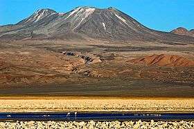 The Lascar volcano, seen from the Chaxas lagoon on the Gran Salar. To the left, in the background, the Aguas Calientes volcano. | |
| Highest point | |
| Elevation | 5,592 m (18,346 ft) [1] |
| Coordinates | 23°22′S 67°44′W / 23.367°S 67.733°WCoordinates: 23°22′S 67°44′W / 23.367°S 67.733°W [1] |
| Geography | |
 Lascar Chile | |
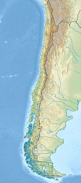
| Location | Northern Chile |
| Parent range | Andes |
| Geology | |
| Mountain type | Stratovolcano |
| Last eruption | October 30, 2015 |
Lascar, a stratovolcano, is the most active volcano of the northern Chilean Andes.
Geographical setting
Lascar is located in the Central Andes of northern Chile, east of the Salar de Atacama,[2] immediately west of the Aguas Calientes volcano, and to the northeast of Laguna Lejía. Other volcanoes in the area include Acamarachi, which is dormant or possibly extinct, and Chiliques, which has developed a new hot spot in its summit crater beginning in 2002 after a period of at least 10,000 years in dormancy.[3]
Regional geology
Volcanoes in the Andes occur in three separate regions, the Northern Volcanic Zone between 2°N and 5°S, the Central Volcanic Zone between 16°S and 28°S and the Southern Volcanic Zone between 33° and 46°.[4]
Local setting
Lascar is part of the Central Volcanic Zone of the Andes.[5] Volcanism of Lascar relates to the subduction of the Nazca Plate beneath the South America Plate.[6][7] The Central Andes contain many hundreds of volcanoes, extending over the countries of Argentina, Bolivia, Chile and Peru. In this remote territory where eruptions are poorly recorded, many volcanoes are higher than 6,000 metres (20,000 ft).[8] These volcanoes are constructed on a crust that is between 50–70 kilometres (31–43 mi) thick.[4] Volcanic centres include calderas and associated large ignimbrites, lava domes and stratovolcanoes.[5] Among the better researched centres belong Galan, Nevados de Payachata, Ollgue, Purico Complex, San Pedro-San Pablo, La Pacana, Tata Sabaya and Tumisa.[9] A number of young volcanoes are found in the region, many of which display fumarolic activity,[10] Guallatiri for example features fumarolic activity that is visible in space-born images.[11] Also fumarolically active are Sabancaya, El Misti, Ubinas, Tacora, Isluga, Irruputuncu, Olca, Ollague, San Pedro, Putana and Lastarria.[12] The largest historical eruption occurred at Huaynaputina in 1600.[8]
Lascar volcano is located in the Antofagasta Region of Chile,[12] and is 5,641 metres (18,507 ft),[13] 5,592 metres (18,346 ft),[12][5][4] 5,450 metres (17,880 ft),[14] or 5,641 metres (18,507 ft) high.[15] With a surface area of 54 square kilometres (21 sq mi), the volcano has a volume of 15 cubic kilometres (3.6 cu mi).[16] The Salar de Atacama is 30 kilometres (19 mi) farther west.[17]
The town of Toconao lies 34 kilometres (21 mi) northwest of Lascar.[18][13] The old location of Talabre is another town in the area. Southwest of the volcano lie Socaire and Peine.[19] Farther away lie San Pedro de Atacama and Paso de Jama,[20] the former lies about 70 kilometres (43 mi) northwest from Lascar.[12]
Lascar is located in the main volcanic arc, on the western margin of the Altiplano.[7] Andesitic-dacitic Aguas Calientes is located just east of Lascar,[21] Miocene-Quaternary volcanic centres in the neighbourhood include Cerro Negro in the north, Acamarachi northeast, Tumisa southwest and the Cordon de Puntas Negras in the south.[19] Tumisa to the south of Lascar was active between 2,5 and 0.4 million years ago.[22] Aguas Calientes is older than Lascar.[16] North and south of Lascar lie Miocene-Pliocene lava domes,[23] east of Lascar lies the La Pacana caldera.[22] Cerro Opla 20 kilometres (12 mi) west of Lascar is a hill formed by Permian-Triassic granite.[24] The 9 kilometres (5.6 mi) long Quebrada de Chaile, the 17 kilometres (11 mi) long Quebrada de Soncor and the 17 kilometres (11 mi) long Quebrada de Talabre canyons run towards Salar de Atacama; they are 30–80 metres (98–262 ft) deep and 80–500 metres (260–1,640 ft) wide.[25] These valleys probably formed from erosion during glacial periods.[16] Geographically, the area is located between the Salar de Atacama and the Altiplano.[5]
Lascar is constructed on top of a ridge formed by the Cerro Corona and Cerro de Saltar lava domes.[22] These lava domes are about 5 million years old.[26] An eruption 16,700 years ago from Corona deposited tephra containing biotite and quartz in the Laguna Leija and generated a rhyodacitic lava. Another debris flow from Corona flowed towards Salar de Atacama.[16]
Geology
Lascar volcano is formed by two individual cones that extend east-west.[27] Aguas Calientes is also located on this trend.[28] Six craters are located on the volcano,[10] showing evidence that activity has migrated westward.[15] Sometimes only five craters are counted, in which case the central one is considered to be the active one.[29] The extinct western cone (also known as Apagado) is constructed by layers of lava and pyroclastics. Its large crater is filled by another cone. Immediately east of it lies the eastern cone and contiguous with the western cone. The eastern cone (also known as Activo)[28] is capped off with three distinct craters. Of these, in 1964 the eastern crater had the largest diametre of 1 kilometre (0.62 mi) but the western crater was the active centre.[27] Measurements made in 1961-1997 determined that the eastern crater is 1 kilometre (0.62 mi) wide and 150–200 metres (490–660 ft) deep, the central crater is 600 metres (2,000 ft) wide and 100–200 metres (330–660 ft) deep and the western crater is 800 metres (2,600 ft) wide and 200–300 metres (660–980 ft) deep. These craters are not collapse calderas.[30] Traces of a previous edifice are visible in the craters, this edifice constitutes the bulk of the eastern cone. Traces of a sector collapse towards northeast and an associated horseshoe-shaped scar are found.[28]
The western of these eastern craters is the currently active one, surrounded by rims that reach heights of 150 metres (490 ft). In 1985, a 150 by 150 metres (490 ft × 490 ft) hot spot was observed in this crater from satellite images.[15] As of 2006, this active crater is 150 metres (490 ft) deep and 800 metres (2,600 ft) wide. In its centre lies a smaller crater, 250 metres (820 ft) deep and 300 metres (980 ft) wide. Many fumaroles occur along the rim of the inner crater.[31]
Large lava flows are noticeable on the flanks of the volcano,[15] they extend from the summit craters, although none of them appears to be associated with the currently active crater.[14] Flows from the first stage of Lascar's activity are exposed at its western foot.[28] A 6 kilometres (3.7 mi) long lava flow on the northern flank reaches almost to Talabre.[15] This lava flow is known as the Tumbres-Talabre lava flow, its margings are 10–40 metres (33–131 ft) high and it features a central channel. The flow advances just north of the head of Quebrada Talabre before entering it over cliffs.[32] Another lava flow on the southwest flank is known as "Capricorn Lava".[26] This dacitic lava was erupted high on Lascar and has a blocky surface. It features well developed levees and a 10 metres (33 ft) thick flow front. Its rocks have a pale gray-blue colour and resembles the Soncor flow compositionally, despite more mafic lavas and pyroclastics being erupted between the two.[33]
An early pyroclastic flow, the Saltar Flow, is exposed on the eastern flank. It was emplaced after the collapse of the oldest edifice, covering Aguas Calientes' western slopes. It was later modified by glacial activity.[28] The Soncor flow is found on the western side of Lascar, part of it also southeast of Lascar. On the western slope, it buries the even older Piedras Grandes flow which only crops out at its margins.[34] While the Piedras Grandes flow was formed by a glacier run that transported blocks with sizes of up to 8 metres (26 ft), Soncor was formed by a large eruption. It is a pyroclastic flow that extended 27 kilometres (17 mi) westward and contained breccia and various magmas. It was accompanied by a Plinian fall deposit. The andesitic pumice Tumbres flow is found on the northwest-west-southwestern slopes of Lascar.[35]
The Quebrada Talabre cuts into the upper flanks of Lascar. Lahar deposits are found in adjacent valleys, suggesting that wetter periods had occurred during Lascar's activity.[32] Traces of glacial action are found on the older parts of Lascar at altitudes above 4,600 metres (15,100 ft) and include meltwater gorges, striated rock surfaces and U-shaped valleys.[36] Moraines are found at Tumisa down to an altitude of 4,850 metres (15,910 ft).[16] The Quebrada Talabre was scoured by pyroclastic flows from the 1993 eruption, exposing bedrock and Tertiary ignimbrites.[37]
The volcano sits above a major local geological trend, the north-south Miscanti Line. Other volcanic centres are also located on this line,[28] including the Corona and Saltar lava domes.[16] The formation of the first cone at Lascar may have been facilitated by the intersection between the Miscanti Line and another east-west oriented lineament, which would have worked as a ascent path for magma.[38]
Composition
Lascar rocks consist of andesite and dacite. Pyroxene is the principal mineral component, although the old Piedras Grandes and Soncor rocks contain hornblende. Other minerals include anhydrite,[30] augite, hypersthene and plagioclase.[13] Additional minerals are apatite, ilmenite, magnetite, olivine, orthopyroxene, pyrrothite, quartz, rhyolite in the groundmass and spinel in inclusions. Dacite has more plagioclase and rhyolite.[35] Component chemicals found at Lascar include anorthite, augite bordering on diopside, bronzite, fassaite, forsterite, hypersthene, pigeonite and more.[39]
The rocks of Lascar belong to the calc-alkaline series.[2] SiO
2 contents range from 55.5-67.8% by weight, and the rocks have medium to large concentrations of potassium.[40] The magmas are influenced by the local crust, but not to the extent noted in Galan or Purico Complex for example.[41] The chemistry of Lascar's rocks is fairly similar to neighbouring Tumisa.[42]
Magma erupted by Lascar appears to form from the mixing of mafic and more evolved magmas; the 1993 eruption deposits contain bands of different rocks.[30] Specifically, basaltic andesite magma is periodically injected into magma chamber where crystal fractionation and mixing processes take place.[43] The process happens frequently, thus the magmas are relatively unevolved.[44] There appear to be two distinct chamber systems, an andesitic one that is responsible for the frequent andesite lava and pyroclastic flow activity and a dacitic one that was involved in the Piedras Grandes and Soncor activities.[45] Presumably, if the supply of mafic magma is steady the products are andesitic, otherwise dacite forms.[44] This mixture origin of Lascar magmas is reflected in the textures of rocks.[46] Temperatures of the magma chamber range 890–970 °C (1,630–1,780 °F), the mafic magmas that are injected in the chamber are about 150–200 °C (302–392 °F) hotter than the extant andesite and dacite. The chamber may be surrounded by skarnic alteration.[47] This alteration gives rise to wollastonite and pyroxene-containing skarn depending on the distance from the magma chamber walls. Metasomatism does further affect rocks derived from magma chamber walls.[48] The oxidation conditions in the magma chamber are favourable for the formation of sulfate,[49] but unfavourable for the deposition of sulfide minerals.[50] The overall magma supply rate of Lascar is 0.02–0.03 cubic metres per second (0.71–1.06 cu ft/s).[51]
A number of xenoliths occur in Lascar's rocks, a large amount of the phenocrysts are ultimately derived from them. Hornfels, skarn and rocks derived from the lava dome ridge Lascar is constructed on form these xenoliths. Minerals encountered in xenoliths include andradite, anhydrite, anorthite, apatite, biotite, calcite, diopside, fassaite, garnet, gypsum, ilmenite, magnetite, monazite, orthopyroxene, perovskite, plagioclase, prehnite, quartz, sphene, thorite, wilkeite, wollastonite and zircon. A number of such xenoliths formed from carbonate rocks that were influenced by magma[52][44] from Lascar and other volcanoes such as Tumisa.[47]
Gas
Lascar emits plumes of gas. Sometimes, white clouds of vapor are released.[10] The bulk of this gas release occurs over many hundreds of fumarolic vents, which are mostly located in the active crater.[31] In December 2002, two fumaroles had temperatures exceeding 295 °C (563 °F).[53] There are noticeable differences between the high and low temperature fumaroles, for example the latter tend to have far more water than carbon dioxide. Also found are carbon monoxide, hydrogen, hydrogen chloride,hydrogen sulfide and smaller amounts helium. Hydrocarbons and other organic compounds are also found in the low temperature fumaroles.[54] Sulfur is released all over the cone, resulting in a noticeable sulfur smell. Part of this gas is precipitated water.[38]
Total amounts of SO
2 released amounted to 27 kilograms per second (3,600 lb/min) in 1989,[55] and 28 kilograms per second (3,700 lb/min) in 2003.[56] Overall sulfur output ranges between 500–2,300 tonnes per day (5.7–26.2 long ton/ks).[31] Hydrogen chloride and hydrogen fluoride are also released in large amounts, with estimates made in 2003-2004 indicating a mass flux of 340,000,000,000 grams per year (380,000,000 oz/Ms) and 150,000,000,000 grams per year (170,000,000 oz/Ms) respectively.[57]
Sulfate dusts are also released in large amounts,[57] about 100000 trillion particles per second.[56]
Gases are partly supplied from shallow magma, considering that the volume of magma erupted is too small to contain all the exhalations.[58] The release of gas by the magma is favoured by strong temperature contrasts between incoming magma and the magma chamber.[49] This may explain the high emission of sulfur dioxide by Lascar.[59] The presence of argon and nitrogen in low-temperature fumaroles indicates that air is involved in their formation,[54] although part of these two gases are non-atmospheric.[60]
Sulfur and chlorine may be derived from the crust, evaporites such as these found at Salar de Atacama, subducted lithosphere or the mantle. Carbon in the gases may come from skarn assimilation.[61] Sulfur isotope data support the notion that evaporite deposits contribute part of Lascar's sulfur.[62] Water appears to be in part magmatic and in part precipitation-derived.[63]
Basement
Lascar is constructed on the Atana ignimbrite, a rhyodacitic sheet which was erupted by La Pacana caldera 4.5-3.7 million years ago.[22] The Pampa Chamaca and Tuyajto ignimbrites are somewhat younger, 2.6-2.2 and less than one million years respectively. These ignimbrites form a 3° slope in the area.[16] Other basement rocks are the sandstone-containing marine Devonian-Carboniferous Lila formation and the red-orange Permian Cas formation containing volcanic rocks and granites,[5][17] as well as the volcanic Permian-Triassic Peine formation and Cerro Negro strata which also contain intruded rocks and lake sediments.[28] These formations are not visible in the Lascar area, but they crop out close to Salar de Atacama.[7] Tertiary sediment and volcanic rocks can also be found.[5] The presence of Mesozoic limestone is indicated by xenoliths in Lascar's lavas; they only crop put farther east in Argentina.[16] This limestone formation has been identified as the Yacoraite formation.[50] Later deposits include the Cenozoic sedimentary Quepe strata. Landforms over this basement include ignimbrites, lava domes and stratovolcanoes.[28]
Climate and biota
Precipitation at Lascar is about 50–100 millimetres per year (0.062–0.125 in/Ms) and consists mostly of snow.[38] Persistent snow exists on the western and southern slopes of the volcano, it partly contributes to the fumarole water.[54] In 1993, yearly precipitation at several towns around Lascar ranged from 2.5–20.1 millimetres (0.098–0.791 in). Lascar is located close to the Atacama Desert, which is one of the world's driest deserts.[64]
During the glacial periods, the volcano most likely featured small glaciers. The equilibrium line at Lascar was at an altitude of 4,700–4,800 metres (15,400–15,700 ft).[16] After 8,500 years ago, the climate in the region became much drier and the amount of erosion decreased substantially.[65]
Due to the dry climate, there is little vegetation at Lascar. Bunch grass and shrubs grow on slopes. In the deep valleys, groundwater and streams can support more plants.[64]
Eruptive history
Lascar volcano is the most active volcano in the Andean Central Volcanic Zone.[66] Most present-day activity consists in the release of fumarolic gas with additional Vulcanian activity that generate eruption columns several 1 kilometre (0.62 mi) high.[18]
The oldest volcanic activity at Lascar occurred less than 50,000 years ago. Activity has alternated between the eastern and western part of the volcano during its history. The eastern edifice formed first ("stage I"), erupting andesite containing pyroxene and eventually forming the Chaile and Saltar pyroclastic flows.[27] Lava flows less than 50 metres (160 ft) issued from the stage I cone and reached lengths of 16 kilometres (9.9 mi). They occur beneath altitudes of 4,100 metres (13,500 ft), their vents buried by later activity.[16] The oldest mafic andesites are less than 43,000 years old, while the Chaile and Saltar pyroclastic flows were erupted over 26,500 years ago. The lavas from the stage I are mostly exposted north and west of Lascar. The Chaile flows are actually formed by two separate units and are found on the southwest flanks of the volcano, up to a distance of 6 kilometres (3.7 mi).[21] They reach thicknesses of 5 metres (16 ft) in the upper unit,[67] and 30 metres (98 ft) in the lower one. The Saltar flow reached widths of 0.7–1.3 kilometres (0.43–0.81 mi) and thicknesses of 5–20 metres (16–66 ft), increasing to 35 metres (115 ft) where the flow had entered valleys. At least nine units form the Saltar deposit, with the northern flows displaying flow welding.[68] These deposits have volumes of 0.1 cubic kilometres (0.024 cu mi) and probably formed when an explosive eruption took place in a lava lake.[51] After the end of stage I, a period of glacial erosion occurred prior to new activity,[38] which created furrows in the Saltar flow. Imprecise argon-argon dating on younger andesites has yielded dates of 14,000 ± 18,000 and 17,000 ± 22,000 years.[68]
Later volcanic activity buried this edifice beneath thin pyroclastic flows. The western edifice formed a complex of lava domes ("stage II").[27] This complex was probably surrounded by a horseshoe-shaped crater open to the west.[69] Possibly, the magma chamber of stage I had almost solidified when the injection of basaltic magma at depths of over 5 kilometres (3.1 mi) triggered a remelting.[70] Andesite-rhyodacite intrusions occurred beneath the volcano,[66] some of these were still hot when the Soncor eruption tore them out of the ground.[71] An ice cap formed over Lascar at that time, feeding two glaciers that extended northeast and southeast away from the volcano.[35]
Piedras Grandes unit
This activity was accompanied by the eruption of block-and-ash flows consisting of andesite and an eruption whose deposits include blocks with sizes of 15 metres (49 ft). This unit formed by stage II is also known as Piedras Grandes.[27] This unit is exposed on the western slopes beneath about 4,900 metres (16,100 ft) altitude and is about 2 kilometres (1.2 mi) wide.[69] It consists of andesite containing amphibole, basaltic andesite and hornblende.[45] The Piedras Grandes unit is over 26,500 years old[21] and consists of large blocks encased in ash.[25] Temperatures have been estimated to be 740–1,060 °C (1,360–1,940 °F) for the andesite and 1,130–1,220 °C (2,070–2,230 °F) for the basaltic andesite.[72] The magmas were formed from a remelted proto-pluton that had been heated and resupplied with volatiles by mafic magmas.[73]
The lava domes interacted with glaciers, resulting in the formation of a glacier run whose deposits are found as far as 10 kilometres (6.2 mi) from the volcano.[45] Blocks with sizes of up to 15 metres (49 ft) were transported by this flow.[69] An alternative theory posits that the Piedras Grandes unit formed when an ice cap on Lascar interacted with a block-and-ash flow erupted by Aguas Calientes.[35]
Soncor eruption
26,450 ± 500 years ago,[66] a major Plinian eruption occurred, erupting 10–15 cubic kilometres (2.4–3.6 cu mi) of ejecta between ash and pyroclastic flows. The deposits left contain both andesite and dacite,[27] with phenocrysts consisting of apatite, augite, biotite, iron-titanium oxides, orthopyroxene and plagioclase in a rhyolite matrix.[74] The Plinian deposit has a colour ranging from white to creamy.[75] Like the Piedras Grandes rocks, they tend towards high potassium quantities and resemble other volcanic rocks of the Central Andes and Lascar in terms of composition.[76] The deposits are formed by a Plinian fallout deposit and an ignimbrite rich in lithics.[25] This Plinian deposit reaches thicknesses of 22 metres (72 ft) and fell from a 22–30 kilometres (14–19 mi) high eruption column.[75]
The Soncor ignimbrite extended as much as 27 kilometres (17 mi) west from the volcano,[25] 10 kilometres (6.2 mi) north and 15 kilometres (9.3 mi) south.[68] It is white, heterogeneous,[45] mostly featureless with only weak sorting,[77] but features a noticeable compositional zonation.[78] The ignimbrite features three facies, one rich in breccia, another rich in pumice and a normal ignimbrite.[75] The magma erupted was formed in a magma chamber starting from andesite, which underwent complex petrogenetic processes.[79] This magma chamber existed at a floor depth of 5–6 kilometres (3.1–3.7 mi) and probably had a complex shape given certain chemical properties of the Soncor rocks. At the time preceding the eruption, the magma chamber had a thermal stratification,[80] injections of mafic magmas had heated the magma chamber and induced convection.[73]
Ignimbrite was channeled to the Salar de Atacama by the Quebrada de Chaile, Quebrada de Soncor, Quebrada de Talabre canyons and some smaller valleys, northeastwards by the Quebrada de Morro Blanco and as far as 11 kilometres (6.8 mi) southeastwards over the Pampa Leija area.[25] In these valleys, the ignimbrite can be as much as 60 metres (200 ft) thick.[77] Pumices are encased in the ignimbrite as lenses and levees and are also found in the terrain above the canyons. Estimated temperatures decreased from 800–900 °C (1,470–1,650 °F) at the vent to 580–600 °C (1,076–1,112 °F) farther down the flows.[81] At the time of emplacement, the ignimbrite was still 200–300 metres (660–980 ft).[82] Magma temperatures have been estimated at 900–1,000 °C (1,650–1,830 °F).[72] The Soncor fallout deposit contains a basal gravelly layer and several layers of andesitic and dacitic pumice which also contain lithics.[83] The total volume of the Soncor eruption products has been estimated to be 5.6 cubic kilometres (1.3 cu mi) dense rock equivalent or 10 cubic kilometres (2.4 cu mi). Lithic rocks derived both from the pre-Soncor volcano and the basement are also represented.[77]
A volatile phase formed inside the magma chamber, containing chlorine and quickly removing most sulfur from the magma. This sulfur extraction was facilitated by the high content of oxygen in the magma which facilitated the formation of sulfur dioxide.[80] Water is a principal volatile and involved in the processes of Plinian eruptions; the water content of the Soncor and Piedras Grandes magmas was about 4-5%.[73] The Soncor magmas were associated with a volatile phase that underwent extensive interaction with the future eruption products.[84]
The previous volcanic edifice was destroyed by this eruption;[45] a caldera may have formed then.[35] The vent was no wider than 2 kilometres (1.2 mi) as it is completely hidden beneath the western cone.[85] Such a vent or caldera is substantially smaller than the volume of rocks erupted, a discrepancy that is also evident in the 1932 eruption of Quizapu. Perhaps the Soncor magma chamber was too deep to collapse.[51]
The Soncor deposit was subsequently affected by glaciation.[35] Subsequently, the stage I edifice was affected by a debris avalanche,[21] which was radiocarbon dated at 22,310 +2700 -2000 years ago in the Quebrada de Chaile.[86] This debris avalanche is 50 metres (160 ft) thick and 25 kilometres (16 mi) long.[85] The Capricorn Lava overlies the Soncor deposits.[84]
Post-Soncor activity
Starting 22,300 years ago,[21] a new stratovolcano grew over the Soncor vent.[27] This volcano was formed by andesite-dacite lava flows ("stage III") and scoria.[25] Lava flows from this stage have thicknesses of 20–60 metres (66–197 ft) and lengths reaching 5 kilometres (3.1 mi). It has a volume of 5–6 cubic kilometres (1.2–1.4 cu mi).[87] The growth of this volcano was preceded by a period of erosion between 20,100-20,800 and 12,500 years ago, coincident with the Lake Minchin humid period.[88] Glaciers in the region reached their maximum size at that time.[89] The deposits left by this erosional period contain no clear evidence of stage III activity; indeed Lascar was probably inactive between 14,000 and 10,500 years ago. However, an eruption of the Cerro Corona lava dome occurred during this period.[87]
Between 9,200 and 9,100 years ago, the Tumbres eruption occurred. This eruption commenced with the eruption of pumice falls that reach thicknesses of less than 1.2 metres (3 ft 11 in). Afterwards, up to four 1–10 metres (3 ft 3 in–32 ft 10 in) thick different units of pyroclastic flows formed deposits up to 10 kilometres (6.2 mi) long.[87] At the end of the eruption, a 1.5 kilometres (0.93 mi) wide caldera formed.[66] The deposits left by this eruption contain basaltic andesite-andesite and have been subject to agglutination and welding.[25] Originally considered part of stage III, it was more recently attributed to stage IV given the considerable (6,000 years) temporal gap between the Tumbres eruption and stage III and the geochemistry of the rocks.[66] The Manquez agglutinate above the Tumbres deposits was formed either by the Tumbres eruption or by the next stage.[87]
Activity subsequently shifted to the eastern edifice, which 7,100 years ago (according to He surface exposure dating) erupted the Tumbres-Talabre lava flow[27] which extends 8 kilometres (5.0 mi) northwest and is 20–30 metres (66–98 ft) thick.[25][90] This flow was originally considered to be of late 19th century age.[15] It probably formed when one of the craters filled with andesitic lava to the point of overflow.[87] The three eastern summit craters formed at the time when the Tumbres-Talabre flow was erupted in remains of the stage I cone.[66] Layers of lava and pyroclastics are discernible in the craters.[87] This edifice is the currently active one, with the deepest of its three summit craters being active.[27]
Historical activity
Volcanic activity at Lascar has been recorded since 1848, chiefly consisting of fumarolic emissions and occasional explosive activity, e.g in 1933.[30] A tall plume of H
2O and SO
2 persists over Lascar.[25] Few records exist from before 1848. Eruptions were observed in March 1960, which was accompanied by earthquakes felt in Toconao, in September 1964 when ash fell in Socaire.[15] In 1984 Lascar awakened to new activity,[30] when satellite images noted the presence of hot spots on the volcano.[18] Landsat images taken during this time indicate that a lava lake may have existed in the central crater.[91] generating a plume of volcanic gases and in September 1986 a vulcanian eruption that dropped ash in Salta, Argentina.[30] This eruption was first noticed when ash fell on Salta and was accompanied by anomalies in the heat emission from the volcano recorded by satellite.[10] The eruption was also observed by geologists in Toconao,[92] where the explosion was violent enough to wake people who were sleeping. Observers noted the formation of cauliflower-shaped cloud that eventually developed into mushroom clouds with a maximum height of 9.4 kilometres (5.8 mi) above the volcano.[93] The eruption itself lasted only about 5 minutes and consisted of two pulses. Ash fall in Salta occurred about one hour after the eruption.[92] This eruption was the most significant of the two decades,[91] having a volcanic explosivity index of 3. Preceding historical eruptions do not exceed 2.[14]
A 200 metres (660 ft) wide and 50 metres (160 ft) high lava dome formed in early 1989. This dome began to shrink in October 1989 and in December 1989 white clouds rose 2 kilometres (1.2 mi) above Lascar's crater. On the 20 February 1990, an eruption column rose 8–14 kilometres (5.0–8.7 mi) above the crater,[30] resulting in ash fall over 100 kilometres (62 mi) away from the volcano.[18] In March 1990, the lava dome had a temperature of 100–200 °C (212–392 °F) with some parts exceeding 900 °C (1,650 °F).[18] Lava bombs with diametres of up to 1.5 metres (4 ft 11 in) were hurled as far as 4 kilometres (2.5 mi) from the crater, presumably as a consequence of the lava dome exploding. Some of the material came from the conduit walls. The lava dome had disappeared, but in early 1992 another lava dome formed, eventually reaching a size of 180–190 metres (590–620 ft) width and 40 metres (130 ft) height and was accompanied by explosions. It probably started shrinking in April 1992, although the shrinkage was directly visible only in November. Small explosions accompanied the shrinkage until by March 1993 the dome had disappeared again.[94]
1993 eruption
Vulcanian explosions occurred 18 April 1993, and on the 19–20 April 1993 a major eruption occurred.[94] The eruption commenced with two explosions at 6:28 and 9:20 local time, forming eruption columns 10 kilometres (6.2 mi) high. Another explosion at 13:02 sent a column 8.5 kilometres (5.3 mi) high.[14] The 1993 eruption lasted 23 hours. The eruption column underwent several collapses, creating pyroclastic flows at least nine[95] or seven times. The strongest pulse occurred 20 April between 6.28-9:20 and sent flows towards the northwest. This pulse generated an eruption column 23 kilometres (14 mi) high.[96]
After being discharged through gaps in the crater rim,[96] on the northwestern and the eastern sides pyroclastic flows reached lengths of 8.5 kilometres (5.3 mi),[97] and 4 kilometres (2.5 mi) on the southern side.[98] These flows reached a thickness of about 5–10 metres (16–33 ft) and advanced through the Quebrada de Talabre on the northern flank, which had intercepted the northern flows. On the southeastern flank, the pyroclastic flows formed a fan extending several hundred 1 metre (3 ft 3 in) into Pampa Leija. Pyroclastic flows reached a speed of 55 metres per second (180 ft/s),[95] and themselves generated ash surges that partly rose above the flows.[99] Hot pyroclastic flows on the southeastern flank covered a surface area of 13–18.5 kilometres (8.1–11.5 mi).[100] The total area covered by the flows is about 14.2 square kilometres (5.5 sq mi) on the northern slopes and 4.3 square kilometres (1.7 sq mi) on the southern slopes.[101] These flows took a long time to cool down, in the Quebrada Tumbres they hadn't cooled down completely in December 1993.[102] The pyroclastic flow deposits contain lithics from several sources and pumice.[103] Pumice mostly accumulated on the surface of the flows and individual stones are up to 30 centimetres (12 in) wide.[96] Lithic blocks are up to 3 metres (9.8 ft) thick.[32] Flow surfaces display pronounced fractures with a V profile,[104] which developed in a year after the eruption.[105] The flows were strongly erosive, extracting rocks and material from the bedrock even far away from the vent.[24] The total volume of these pyroclastic flows is about 0.06 cubic kilometres (0.014 cu mi).[106] The speed of these flows has been estimated at 100–700 kilometres per hour (62–435 mph).[14] A noticeable erosion occurred in the areas where pyroclastic flows had passed over, forming abrasion surfaces and removing loose detritus from the ground.[107] Additional surfaces were covered by ash cloud surges, reaching thicknesses of no more than 5 centimetres (2.0 in) on the sides of the pyroclastic flows.[32] The pyroclastic flow surfaces subsided after the eruption, with pulses of faster subsidence coinciding with the 1995 Antofagasta earthquake and the 2007 Tocopilla earthquake.[108]
Tephra fall from this eruption was recorded in Argentina including the capital Buenos Aires 1,500 kilometres (930 mi) away, Brazil, Paraguay and Uruguay.[97] Over 0.1 millimetres (0.0039 in) fell over a surface area of over 850,000 square kilometres (330,000 sq mi).[12] Lava bombs were thrown as far as 5 kilometres (3.1 mi) away.[97] This eruption is the most significant eruption of Lascar in the last 9,000 years, with a volcano explosivity index of 4.[14][18] It caused noticeable changes in the morphology of the volcano, including the formation of a new fracture along the summit craters.[109] About 900,000 tonnes (890,000 long tons; 990,000 short tons) gypsum were deposited in the drainages around the volcano, forming a significant supply of sulfur in the region.[110]
Post-1993 activity
After this eruption, a lava dome reformed by April, reaching a diametre of 380 metres (1,250 ft). It started to shrink again by May. 17 December 1993 another explosion created an eruption column 8–10 kilometres (5.0–6.2 mi) high. By 28 December the dome had subsided completely in the centre, leaving only its margins. Subsequently, a number of fumaroles were active around the crater.[97] Explosive eruptions accompanied by the formation of eruption columns reaching heights of several 1 kilometre (0.62 mi), sometimes leading to ash fall in Jujuy, Argentina, occurred in 27 February 1994, July 1994, November 1994, March 1995, 10 May 1995, 20 July 1995 and 18 October 1996.[111] During the July 1995 eruption, subsidence was noted inside the central crater from satellite images.[112] The collapse structures during this activity were enlarged compared to these of previous activity, possibly because the April 1993 eruption had emptied part of the system.[58] Another explosive eruption occurred in July 2000,[113] and minor explosions were recorded in October 2002 and December 2003.[109] Activity between 1993 and 2000 was not accompanied by deformation of the edifice.[114] During the July 2000 eruption, an ash plume was carried 660 kilometres (410 mi) east.[31]
Further activity occurred in May 2005 with a 8–10 kilometres (5.0–6.2 mi) high ash cloud and April 2006. [31]
An alternating cycle of fumarolic activity, an accumulation of fumarolic gases in the conduit and lava dome, explosive activity followed by renewed fumarolic activity has characterized Lascar's activity since 1984. Explosive activity presumably occurs when gases can no longer escape.[2] This occurs because as the magma loses its gas content, the amount of pores in it and thus the permeability to gas decrease. Further, fractures permitting gas passage are obstructed when the magma contracts.[115] During most of the time, numerous fumaroles within the crater form a plume that reaches an altitude of 1,000 metres (3,300 ft). During minor explosive eruptions, eruption columns reach heights of no more than 5,000 metres (16,000 ft).[111] This cycle ended after 1993, probably because the April 1993 eruption modified the conditions in the volcanic system.[58] Alternatively, the cycle may have continued, to reach another lava dome collapse stage in early 2003.[20] While eruptions before 1993 had always been preceded by a reduction in heat radiated from the volcano, such a reduction in 1999-2000 did not lead to an eruption, and when an eruption took place in July 2000 it was preceded by only a brief drop in heat radiation.[116]
Modern activity and the current threat
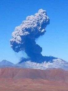
Another series of eruptions began on 18 April 2006 and were continuing as of 2011, and the latest eruption began on 30 October 2015, producing a small plume of ash.[117]
Monitoring and threats
Because of the volcano's remote location, much information on its activity comes from remote sensing.[98] In addition, occasional reconnaissance flights, seismographic monitoring and infrequent visits of the volcano occur.[18] Activity of Lascar has been monitored by Thematic Mapper, which has been used to monitor volcanic activity since 1985, when hot spots were observed on Lascar.[118] The eruptions of April 1993 and September 1986 were both preceded by a reduction of thermal radiation observed by Thematic Mapper.[18]
Explosive eruptions and ash falls are the major threat from Lascar volcano. Sector collapse and lahars did occur in the past history, but are unlikely to be present-day hazards.[89]
See also
Notes
- 1 2 "Láscar". Global Volcanism Program. Smithsonian Institution. Retrieved 2006-04-28.
- 1 2 3 Matthews, Gardeweg & Sparks 1997, p. 72.
- ↑ "Chiliques Volcano, Chile". Visible Earth. NASA. Retrieved 2011-01-02.
- 1 2 3 Matthews, Jones & Gardeweg 1994, p. 401.
- 1 2 3 4 5 6 Calder, Sparks & Gardeweg 2000, p. 202.
- ↑ Mather et al. 2004, p. 1.
- 1 2 3 Matthews et al. 1996, p. 510.
- 1 2 Francis & Rothery 1987, p. 614.
- ↑ Matthews, Jones & Gardeweg 1994, p. 401,403.
- 1 2 3 4 Glaze et al. 1989, p. 151.
- ↑ Francis & Rothery 1987, p. 616.
- 1 2 3 4 5 Tassi et al. 2008, p. 172.
- 1 2 3 Glaze et al. 1989, p. 149.
- 1 2 3 4 5 6 Denniss et al. 1998, p. 802.
- 1 2 3 4 5 6 7 Francis & Rothery 1987, p. 615.
- 1 2 3 4 5 6 7 8 9 10 Gardeweg, Sparks & Matthews 1998, p. 92.
- 1 2 Gardeweg, Sparks & Matthews 1998, p. 90.
- 1 2 3 4 5 6 7 8 Wooster & Rothery 1997, p. 567.
- 1 2 Gardeweg, Sparks & Matthews 1998, p. 91.
- 1 2 Mather et al. 2004, p. 2.
- 1 2 3 4 5 Calder, Sparks & Gardeweg 2000, p. 204.
- 1 2 3 4 Calder, Sparks & Gardeweg 2000, p. 203.
- ↑ Harris et al. 1997, p. 59.
- 1 2 Calder, Sparks & Gardeweg 2000, p. 223.
- 1 2 3 4 5 6 7 8 9 Calder, Sparks & Gardeweg 2000, p. 205.
- 1 2 Matthews, Jones & Gardeweg 1994, p. 402.
- 1 2 3 4 5 6 7 8 9 Matthews, Gardeweg & Sparks 1997, p. 73.
- 1 2 3 4 5 6 7 8 Matthews, Jones & Gardeweg 1994, p. 403.
- ↑ Gardeweg, Sparks & Matthews 1998, p. 89.
- 1 2 3 4 5 6 7 Matthews, Gardeweg & Sparks 1997, p. 74.
- 1 2 3 4 5 Tassi et al. 2008, p. 173.
- 1 2 3 4 Sparks et al. 1997, p. 559.
- ↑ Matthews, Jones & Gardeweg 1994, pp. 409-411.
- ↑ Matthews, Jones & Gardeweg 1994, p. 404.
- 1 2 3 4 5 6 Matthews, Jones & Gardeweg 1994, p. 405.
- ↑ Sparks et al. 1997, p. 562.
- ↑ Sparks et al. 1997, p. 560.
- 1 2 3 4 Matthews, Jones & Gardeweg 1994, p. 428.
- ↑ Matthews, Jones & Gardeweg 1994, pp. 406-407.
- ↑ Matthews, Jones & Gardeweg 1994, p. 414.
- ↑ Matthews, Jones & Gardeweg 1994, p. 421.
- ↑ Matthews, Jones & Gardeweg 1994, p. 422.
- ↑ Matthews, Sparks & Gardeweg 1999, pp. 1892-1893.
- 1 2 3 Matthews, Jones & Gardeweg 1994, p. 411.
- 1 2 3 4 5 Matthews, Sparks & Gardeweg 1999, p. 1893.
- ↑ Matthews, Jones & Gardeweg 1994, p. 406.
- 1 2 Matthews, Jones & Gardeweg 1994, p. 412.
- ↑ Matthews et al. 1996, p. 516.
- 1 2 Matthews, Jones & Gardeweg 1994, p. 413.
- 1 2 Matthews et al. 1996, p. 528.
- 1 2 3 Gardeweg, Sparks & Matthews 1998, p. 102.
- ↑ Matthews et al. 1996, p. 513.
- ↑ Tassi et al. 2008, p. 173,175.
- 1 2 3 Tassi et al. 2008, p. 175.
- ↑ Mather et al. 2004, p. 7.
- 1 2 Mather et al. 2004, p. 18.
- 1 2 Mather et al. 2004, p. 8.
- 1 2 3 Matthews, Gardeweg & Sparks 1997, p. 81.
- ↑ Matthews, Jones & Gardeweg 1994, p. 426.
- ↑ Tassi et al. 2008, p. 176,178.
- ↑ Matthews, Jones & Gardeweg 1994, pp. 428-429.
- ↑ Risacher & Alonso 2001, p. 327.
- ↑ Tassi et al. 2008, p. 176.
- 1 2 Risacher & Alonso 2001, p. 321.
- ↑ Gardeweg, Sparks & Matthews 1998, pp. 101-102.
- 1 2 3 4 5 6 Matthews, Sparks & Gardeweg 1999, p. 1892.
- ↑ Gardeweg, Sparks & Matthews 1998, p. 95.
- 1 2 3 Gardeweg, Sparks & Matthews 1998, p. 94.
- 1 2 3 Gardeweg, Sparks & Matthews 1998, p. 96.
- ↑ Matthews, Sparks & Gardeweg 1999, p. 1913.
- ↑ Matthews, Sparks & Gardeweg 1999, p. 1897.
- 1 2 Matthews, Sparks & Gardeweg 1999, p. 1900.
- 1 2 3 Matthews, Sparks & Gardeweg 1999, p. 1917.
- ↑ Matthews, Sparks & Gardeweg 1999, p. 1895.
- 1 2 3 Gardeweg, Sparks & Matthews 1998, p. 97.
- ↑ Matthews, Sparks & Gardeweg 1999, p. 1901.
- 1 2 3 Calder, Sparks & Gardeweg 2000, p. 207.
- ↑ Matthews, Sparks & Gardeweg 1999, p. 1903.
- ↑ Matthews, Sparks & Gardeweg 1999, p. 1914.
- 1 2 Matthews, Sparks & Gardeweg 1999, p. 1915.
- ↑ Calder, Sparks & Gardeweg 2000, p. 211.
- ↑ Gardeweg, Sparks & Matthews 1998, p. 98.
- ↑ Calder, Sparks & Gardeweg 2000, p. 210.
- 1 2 Matthews, Jones & Gardeweg 1994, p. 409.
- 1 2 Gardeweg, Sparks & Matthews 1998, p. 99.
- ↑ Gardeweg, Sparks & Matthews 1998, p. 94,97.
- 1 2 3 4 5 6 Gardeweg, Sparks & Matthews 1998, p. 100.
- ↑ Gardeweg, Sparks & Matthews 1998, p. 99,100.
- 1 2 Gardeweg, Sparks & Matthews 1998, p. 103.
- ↑ Gardeweg, Sparks & Matthews 1998, p. 101.
- 1 2 Francis & Rothery 1987, p. 617.
- 1 2 Glaze et al. 1989, p. 152.
- ↑ Glaze et al. 1989, p. 153.
- 1 2 Matthews, Gardeweg & Sparks 1997, p. 75.
- 1 2 Calder, Sparks & Gardeweg 2000, p. 217.
- 1 2 3 Sparks et al. 1997, p. 558.
- 1 2 3 4 Matthews, Gardeweg & Sparks 1997, p. 76.
- 1 2 Harris et al. 1997, p. 55.
- ↑ Calder, Sparks & Gardeweg 2000, p. 219.
- ↑ Harris et al. 1997, p. 56.
- ↑ Denniss et al. 1998, p. 808.
- ↑ Wooster 2001, p. 849.
- ↑ Calder, Sparks & Gardeweg 2000, p. 221.
- ↑ Whelley et al. 2011, p. 514.
- ↑ Whelley et al. 2011, p. 515.
- ↑ Calder, Sparks & Gardeweg 2000, p. 228.
- ↑ Sparks et al. 1997, p. 557.
- ↑ Whelley et al. 2011, p. 521,522.
- 1 2 Pavez et al. 2006, p. 308.
- ↑ Risacher & Alonso 2001, p. 333.
- 1 2 Matthews, Gardeweg & Sparks 1997, p. 77.
- ↑ Pavez et al. 2006, p. 315.
- ↑ Wooster 2001, p. 847.
- ↑ Pavez et al. 2006, p. 313.
- ↑ Wooster & Rothery 1997, p. 568.
- ↑ Wooster 2001, p. 848.
- ↑ http://www.wired.com/2015/10/unexpected-eruption-from-chiles-lascar/
- ↑ Harris et al. 1997, p. 49.
Sources
- Calder, E.S.; Sparks, R.S.J.; Gardeweg, M.C. (December 2000). "Erosion, transport and segregation of pumice and lithic clasts in pyroclastic flows inferred from ignimbrite at Lascar Volcano, Chile". Journal of Volcanology and Geothermal Research. 104 (1-4): 201–235. doi:10.1016/S0377-0273(00)00207-9.
- Denniss, A. M.; Harris, A. J. L.; Rothery, D. A.; Francis, P. W.; Carlton, R. W. (January 1998). "Satellite observations of the April 1993 eruption of Lascar volcano". International Journal of Remote Sensing. 19 (5): 801–821. doi:10.1080/014311698215739.
- Francis, P. W.; Rothery, D. A. (1987). "Using the Landsat Thematic Mapper to detect and monitor active volcanoes: An example from Lascar volcano, northern Chile". Geology. 15 (7): 614. doi:10.1130/0091-7613(1987)15<614:UTLTMT>2.0.CO;2.
- Gardeweg, M. C.; Sparks, R. S. J.; Matthews, S. J. (1 February 1998). "Evolution of Lascar Volcano, Northern Chile". Journal of the Geological Society. 155 (1): 89–104. doi:10.1144/gsjgs.155.1.0089.
- Glaze, L. S.; Francis, P. W.; Self, S.; Rothery, D. A. (May 1989). "The 16 September 1986 eruption of Lascar volcano, north Chile: Satellite investigations". Bulletin of Volcanology. 51 (3): 149–160. doi:10.1007/BF01067952.
- Harris, Andrew J. L.; Butterworth, Anna L.; Carlton, Richard W.; Downey, Ian; Miller, Peter; Navarro, Pedro; Rothery, David A. (23 September 1997). "Low-cost volcano surveillance from space: case studies from Etna, Krafla, Cerro Negro, Fogo, Lascar and Erebus". Bulletin of Volcanology. 59 (1): 49–64. doi:10.1007/s004450050174.
- Mather, T. A.; Tsanev, V. I.; Pyle, D. M.; McGonigle, A. J. S.; Oppenheimer, C.; Allen, A. G. (16 November 2004). "Characterization and evolution of tropospheric plumes from Lascar and Villarrica volcanoes, Chile". Journal of Geophysical Research: Atmospheres. 109 (D21): n/a–n/a. doi:10.1029/2004JD004934.
- Matthews, S. J.; Jones, A. P.; Gardeweg, M. C. (1 April 1994). "Lascar Volcano, Northern Chile; Evidence for Steady-State Disequilibrium". Journal of Petrology. 35 (2): 401–432. doi:10.1093/petrology/35.2.401.
- Matthews, S. J.; Marquillas, R. A.; Kemp, A. J.; Grange, F. K.; Gardeweg, M. C. (July 1996). "Active skarn formation beneath Lascar Volcano, northern Chile: a petrographic and geochemical study of xenoliths in eruption products". Journal of Metamorphic Geology. 14 (4): 509–530. doi:10.1046/j.1525-1314.1996.00359.x.
- Matthews, S. J.; Sparks, R. S. J.; Gardeweg, M. C. (1 December 1999). "The Piedras Grandes-Soncor Eruptions, Lascar Volcano, Chile; Evolution of a Zoned Magma Chamber in the Central Andean Upper Crust". Journal of Petrology. 40 (12): 1891–1919. doi:10.1093/petroj/40.12.1891.
- Matthews, Stephen J.; Gardeweg, Moyra C.; Sparks, R. Stephen J. (23 September 1997). "The 1984 to 1996 cyclic activity of Lascar Volcano, northern Chile: cycles of dome growth, dome subsidence, degassing and explosive eruptions". Bulletin of Volcanology. 59 (1): 72–82. doi:10.1007/s004450050176.
- Pavez, A.; Remy, D.; Bonvalot, S.; Diament, M.; Gabalda, G.; Froger, J-L.; Julien, P.; Legrand, D.; Moisset, D. (February 2006). "Insight into ground deformations at Lascar volcano (Chile) from SAR interferometry, photogrammetry and GPS data: Implications on volcano dynamics and future space monitoring". Remote Sensing of Environment. 100 (3): 307–320. doi:10.1016/j.rse.2005.10.013.
- Risacher, François; Alonso, Hugo (September 2001). "Geochemistry of ash leachates from the 1993 Lascar eruption, northern Chile. Implication for recycling of ancient evaporites". Journal of Volcanology and Geothermal Research. 109 (4): 319–337. doi:10.1016/S0377-0273(01)00198-6.
- Sparks, R. S. J.; Gardeweg, M. C.; Calder, E. S.; Matthews, S. J. (7 May 1997). "Erosion by pyroclastic flows on Lascar Volcano, Chile". Bulletin of Volcanology. 58 (7): 557–565. doi:10.1007/s004450050162.
- Tassi, F.; Aguilera, F.; Vaselli, O.; Medina, E.; Tedesco, D.; Delgado Huertas, A.; Poreda, R.; Kojima, S. (3 June 2008). "The magmatic- and hydrothermal-dominated fumarolic system at the Active Crater of Lascar volcano, northern Chile". Bulletin of Volcanology. 71 (2): 171–183. doi:10.1007/s00445-008-0216-z.
- Whelley, Patrick L.; Jay, J.; Calder, E. S.; Pritchard, M. E.; Cassidy, N. J.; Alcaraz, S.; Pavez, A. (27 September 2011). "Post-depositional fracturing and subsidence of pumice flow deposits: Lascar Volcano, Chile". Bulletin of Volcanology. 74 (2): 511–531. doi:10.1007/s00445-011-0545-1.
- Wooster, M. J.; Rothery, D. A. (7 May 1997). "Thermal monitoring of Lascar Volcano, Chile, using infrared data from the along-track scanning radiometer: a 1992-1995 time series". Bulletin of Volcanology. 58 (7): 566–579. doi:10.1007/s004450050163.
- Wooster, Martin J. (1 March 2001). "Long-term infrared surveillance of Lascar Volcano: Contrasting activity cycles and cooling pyroclastics". Geophysical Research Letters. 28 (5): 847–850. doi:10.1029/2000GL011904.
Further reading
- González-Ferrán, Oscar (1995). Volcanes de Chile (in Spanish). Santiago, Chile: Instituto Geográfico Militar. ISBN 956-202-054-1.
External links
- Last Frontier Ex- Volcán Lascar
- Atacama Photo Gallery - panoramic view into the crater of Lascar
- SI Google Earth Placemarks - Smithsonian Institution Global Volcanism Program: download placemarks with SI Holocene volcano-data.
| Wikimedia Commons has media related to Lascar Volcano. |
