Tungurahua
| Tungurahua | |
|---|---|
 View from Riobamba (September 2011) | |
| Highest point | |
| Elevation | 5,023 m (16,480 ft) [1] |
| Prominence | 1,554 m (5,098 ft) |
| Listing | Ultra |
| Coordinates | 1°28′12″S 78°26′41″W / 1.4700°S 78.4447°WCoordinates: 1°28′12″S 78°26′41″W / 1.4700°S 78.4447°W [2] |
| Geography | |
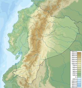
| Location | Ecuador |
| Parent range | Andes |
| Topo map | IGM, CT-ÑIV-D1[3] |
| Geology | |
| Age of rock | Holocene (Gomez 1994) |
| Mountain type | Stratovolcano (active) |
| Volcanic arc/belt | Northern Volcanic Zone |
| Last eruption | 2010 to 2015 (ongoing) |
| Climbing | |
| First ascent | 1873 by Alphons Stübel and Wilhelm Reiss |
| Easiest route | Scrambling/Snow/Ice PD |
Tungurahua, (/tʊŋɡʊˈrɑːwə/; from Quichua tunguri (throat), rahua (fire): "Throat of Fire"[4] or from Panzaleo) is an active stratovolcano located in the Cordillera Oriental of Ecuador. The volcano gives its name to the province of Tungurahua. Volcanic activity restarted on August 19, 1999,[5] and is ongoing as of 2013, with several major eruptions since then, the last starting on 1 February 2014.[6][7]
Geography and geology
Location
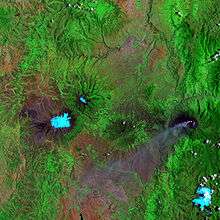
Tungurahua (5,023 m) is located in the Cordillera Oriental of the Andes of central Ecuador, 140 kilometres (87 mi) south of the capital Quito. Nearby notable mountains are Chimborazo (6,310 m) and El Altar (5,319 m). It rises above the small thermal springs town of Baños de Agua Santa (1,800 m) which is located at its foot 8 km to the north. Other nearby towns are Ambato (30 km to the northwest) and Riobamba (30 km to the southwest). Tungurahua is part of the Sangay National Park.
Glacier
With its elevation of 5,023 m, Tungurahua just over tops the snow line (about 4,900 m). Tungurahua's top is snow covered and did feature a small summit glacier which melted away after the increase of volcanic activity in 1999.
Volcanism
Today's volcanic edifice (Tungurahua III) is constructed inside its predecessor's (Tungurahua II) caldera which collapsed about 3000 (±90) years ago. The original edifice (Tungurahua I) collapsed at the end of the late Pleistocene.[8]
Historical volcanic activity
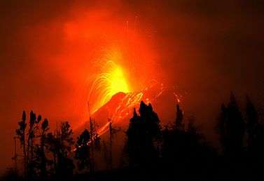
Tungurahua's eruptions are strombolian. They produce andesite and dacite. All historical eruptions originated from the summit crater and have been accompanied by strong explosions, pyroclastic flows and sometimes lava flows. In the last 1,300 years Tungurahua entered every 80 to 100 years into an activity phase of which the major have been the ones of 1773, 1886 and 1916–1918.[9]
Recent volcanic activity
In 2000, after a long period of quiescence, the volcano entered an eruptive phase that continues to this day (as of April 2014). The renewed activity in October 1999 produced major ashfall and led to the temporary evacuation of more than 25,000 inhabitants from Baños and the surrounding area[10] Activity continued at a medium level until May 2006, when activity increased dramatically, culminating in violent eruptions on 14 July 2006 and 16 August 2006. The 16 August 2006 eruption has been the most violent since activity commenced in 1999. This eruption was accompanied by a 10 km high ash plume which spread over an area of 740 by 180 km,[11] depositing ash and tephra to the southwest of the volcano. Several pyroclastic flows were generated that killed at least five people, and destroyed a number of hamlets and roads on the eastern and northwestern slopes of the volcano.[12]
A further eruption and evacuation occurred on 4 December 2010. Ecuador's National Agency of Risk Control issued a "red alert", later downgraded to orange.[13] The Ecuadorean Institute for Geophysics reported a rapid increase in seismic activity, a number of explosions and an ash cloud reaching 2 kilometres (1.2 mi) in height.[14] Another eruption occurred on 18 December 2012 forcing evacuation of those living on the volcano's slopes.[15] The volcano erupted again in July 2013.[16][17] On 1 February 2014, the volcano erupted again.
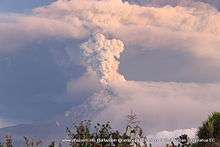

The Volcano erupted Friday 26th of February, 2016, at 12.00 midday, shooting an ash cloud 5,000m into the air. It is still erupting regularly as of Thursday 4th March 2016..
History
Etymology
According to one theory the name Tungurahua is a combination of the Quichua tunguri (throat) and rahua (fire) meaning "Throat of Fire".[4] According to another theory it is based on the Quichua uraua for crater.[18] Tungurahua is also known as "The Black Giant" and, in local indigenous mythology it is allegedly referred to as Mama Tungurahua ("Mother Tungurahua").
First ascent
During their seven-year-long South America expedition (1868 to 1876), the German volcanologists Alphons Stübel and Wilhelm Reiss climbed Cotopaxi (Reiss with Angel Escobar; 28 November 1872) and Tungurahua (Stübel with Eusebio Rodruguez; 9 February 1873).[18]
See also
References
- ↑ Several elevation data between 5,016 and 5,029 m are used, 5,023 m is the one used on IGM maps. Used extremes are: 5,087 m (Stübel 1897) and 5,005 m (Neate 1994).
- ↑ "Tungurahua". Global Volcanism Program. Smithsonian Institution. Retrieved 2009-01-01.
- ↑ IGM (Instituto Geografico Militar, Ecuador) (1989). "Baños Ecuador, CT-ÑIV-D1". Archived from the original on 2008-12-19. Retrieved 2008-01-26.
- 1 2 "In the shadow of the Tungurahua volcano". BBC News. 7 September 2006.
- ↑ "Tungurahua volcano erupts in Ecuador". NBC News. 19 Aug 2012.
- ↑ "Ecuador's Tungurahua Volcano shoots ash and lava". Associated Press. 2014-02-01.
- ↑ http://www.nytimes.com/2015/08/25/science/mount-tambora-volcano-eruption-1815.html?_r=0 A Volcanic Eruption That Reverberates 200 Years Later
- ↑ "Geología". Volcán Tungurahua. IGEPN. Archived from the original on 2006-01-16.
- ↑ "Historia". Volcán Tungurahua. IGEPN. Archived from the original on 2005-12-16.
- ↑ "Ecuadoreans Wait Uneasily On Volcanoes". New York Times. 1999-11-28.
- ↑ "Volcán Tungurahua - Ecuador". IGEPN. Archived from the original on 2005-09-07.
- ↑ Kramer, Jack (2006-08-16). "Volcano Erupts". National Ledger.
- ↑ CNN Wire Staff (5 December 2010). "Volcano known as the 'Throat of Fire' erupts in Ecuador". CNN Wire. Retrieved 5 December 2010.
- ↑ "Tungurahua volcano prompts evacuation in Ecuador". BBC News. 4 December 2010.
- ↑ "Ecuador's Tungurahua volcano threatens local villages". BBC News. 18 December 2012.
- ↑ "Tungurahua volcano in Ecuador spews huge ash plume forcing hundreds from their homes". Daily Telegraph. 15 July 2013. Retrieved 15 July 2013.
- ↑ "Eruption of the Tungurahua volcano in Ecuador". CIMSS Satellite Blog. 14 July 2013.
- 1 2 Schmudlach, Günter (2001). Bergführer Ecuador. Panico Alpinverlag. ISBN 3-926807-82-2.
- Gomez, Nelson (1994). Atlas del Ecuador. Editorial Ediguias. ISBN 9978-89-009-2.
- IG-EPN (Instituto Geofisico Escuela Politecnica Nacional, Ecuador). "Tungurahua". Archived from the original on 2006-08-24. Retrieved 2006-08-18.
- Neate, Jill (1994). Mountaineering in the Andes. Expedition Advisory Centre. ISBN 0-907649-64-5.
- Ruiz, M; et al. (2006). Source constraints of Tungurahua volcano explosion events. Bulletin of Volcanology. Springer.
External links
| Wikimedia Commons has media related to: |
| Wikinews has related news: Volcano eruption in Ecuador kills six and destroys several small villages |
- Instituto Geofisico del Ecuador (Spanish)
- Climbing information for Tungurahua on summitpost.org
- Banos Ecuador Weather | Daily Report