List of crossings of the Upper Passaic River
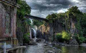
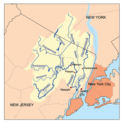
The Upper Passaic River in New Jersey is the section of the Passaic River above the Dundee Dam, including the Great Falls. The entire river flows for 81 miles from its river's source in Mendham to the river mouth at Newark Bay in the northeastern part of the state.[1] The Passaic traverses 45 municipalities, and its watershed provides drinking water for more than 3.5 million people in the region.[2][3] The midpoint of the upper river generally delineates the Passaic-Bergen, Passaic-Essex, Essex-Morris, Morris-Union and sections of the Morris-Somerset county lines.
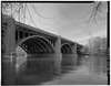
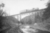
Over 100 crossings have been built along the lower and upper river,[4] and nearly 100 on the Upper Passaic alone, as listed below. In the colonial era the first along the lower reaches was at Bridge Street in Newark.[5] and the first on the upper river was Totowa Bridge, constructed before 1737.[6] The creation of Society for Establishing Useful Manufactures in 1791[7][8] began a period of development of cities and industries along the river. The emergence of the early railroads in the state led to further industrialization and urbanization and many rail bridges.[9] The flood of 1903 caused damage or destruction of most bridges in the vicinity of Paterson.[10][11] The advent of the automobile age and suburbanization in the early and mid-20th century saw the construction of highway bridges in northern New Jersey.[9][12]
Crossings


.tif.png)


Passaic_River.tif.png)


Power lines
In addition to other crossings power transmission lines pass over the river several times. The Public Service Electric and Gas Company (PSE&G) Northern Inner Ring Transmission Line runs from Metuchen Substation to Athenia Substation in Clifton via Roseland Substation and also includes right of way from Roseland Substation to West Orange Substation. The Pennsylvania-New Jersey Interconnection (PJM Interconnection) Bushkill to Roseland Transmission Line extends from Roseland to Hardwick Township in Warren County. Jersey Central Power and Light also has lines across the river.
Abbreviations and definitions
- CR=County Route
- DL&W=Delaware, Lackawanna and Western Railroad
- Erie=Erie Railroad
- EB =Eastbound
- EL=Erie Lackawanna Railway
- ME=Morristown and Erie Railway
- MP = Mile point distance from river mouth and milepost (mile marker) distance from point of origin of train line or beginning of highway
- NRHP=National Register of Historic Places
- NJDOT=New Jersey Department of Transportation
- NJM=New Jersey Midland Railway
- NJRHP=New Jersey Register of Historic Places
- NJT=New Jersey Transit Rail Operations
- NJTA=New Jersey Turnpike Authority
- NYS&W=New York, Susquehanna and Western Railway
- NS=Norfolk Southern Railway
- PVWC=Passaic Valley Water Commission
- SHPO=State Historic Preservation Office
- WB =Westbound
- Dual bridges = two separate parallel structures on same highway [101]
See also
-
 Bridges portal
 -
 New Jersey portal
 - List of dams and reservoirs in New Jersey
- Passaic River Flood Tunnel
- List of crossings of the Hackensack River
- List of bridges, tunnels, and cuts in Hudson County
- List of county routes in Bergen County, New Jersey
- List of county routes in Passaic County, New Jersey
- List of county routes in Morris County, New Jersey
Sources
- "Historic Bridge Survey (1991-1994)". NJDOT. 2001.
- "New Jersey and National Registers of Historic Places". NJ DEP - State Historic Preservation Office.
- "Masonry and Metal The Historic Bridges of Bergen County, New Jersey" (PDF). Richard Grubb and Associates. 2008.
- "Bridges over the Passaic River". Passaic River Basin.
- "Bridgehunter: Passaic River".
- "Bridge Statistics for Paterson, New Jersey (NJ)". www.city-data.com.
- "BridgesNYC".
- Jag9889. "Passaic River Bridges". Flickr.
- "National Bridge Inventory Database".
- Olsen, Kevin K. (2008), A Great Conveniency A Maritime History of the Passaic River, Hackensack River, and Newark Bay, American History Imprints, ISBN 9780975366776
- "County Routes" (PDF). Passaic County.
- "Passaic County Road System". Passaic County. 2001.
- Bauer, Ruth (May 2001). "Street Name Changes Paterson, NJ". Passaic County Historical Society.
- "National Bridge Inventory 2015 (NJ) NBI ASCII Files: Disclaimer Title 23 - United States Code Section409 - Discovery and Admission as Evidence of Certain Reports and Surveys". Federal Highway Administration. August 5, 2015.
- "Interim Bridge Report" (PDF). NJDOT. August 9, 2007. Retrieved 1 December 2016.
References
- 1 2 3 Cowen, Richard (May 6, 2007). "Not-so-old-man river" (PDF). The Record. Retrieved 7 November 2016.
- 1 2 "Streams of the Great Swamp Watershed: Upper Passaic River". Great Swamp Watershed Association. Retrieved 2 November 2016.
- 1 2 "2011 – 2015 Business Plan" (PDF). Passaic River Coalition. 2010. Retrieved 31 October 2016.
The source of the Passaic River begins near Mendham Township where small streams come together to form a brook running along the edge of Mendham High School's athletic field. It continues through open farm land and eventually collects water from eight counties in New Jersey and two in New York. Forty-five municipalities line its banks as it flows into Newark Bay and the whole watershed contains 118 municipalities. The river is about 81 miles long; the 935-square mile watershed is the primary water supply for over three and a half million people and major industries.
- 1 2 3 4 5 "Interim Bridge Report" (PDF). NJDOT. August 9, 2007. Retrieved 1 December 2016.
- ↑ Olsen, Kevin K. (2008), A Great Conveniency A Maritime History of the Passaic River, Hackensack River, and Newark Bay, American History Imprints, ISBN 9780975366776
- 1 2 Graf, E. M. (April 1944). "Totowa Bridge". The Passaic County Historical Society. Retrieved 30 November 2016.
- ↑ "History of Development". PVWC. Retrieved 7 November 2016.
- ↑ Friends of the Great Falls S.U.M.
- 1 2 "New Jersey Historic Bridge Survey" (PDF). NJDOT. September 1994. Retrieved 7 November 2016.
Within the epoch of New Jersey's transportation history from the 17th century to 1945, two periods stand out as extraordinary for their rapid pace of change and growth. The first, running from about 1800 to 1860, saw internal improvements and technological advances such as turnpikes, canals, and railroads. They were all aimed at greater capacity, speed, directness, flexibility, and regularity of service than could be achieved by earlier modes of river navigation and overland travel. Historian George Rogers Taylor has quite correctly called 1800-1860 the "transportation revolution." The second extraordinary period of transportation growth occurred from 1919 to 1936, and was, in terms of historian Bruce Seely, "the golden age of highway building." During this period, New Jersey's road and highway bridges were substantially modernized to handle modern load requirements and increased volume of vehicular traffic. The result was to shift emphasis from railroads to highways.
- ↑ Ensslin, John C. (September 2, 2011). "1903 flood still ranks as North Jersey's worst". The Record. Retrieved 14 November 2016.
- 1 2 Leighton, Marshall Ora (1904). "The Passaic Flood Of 1903" (PDF). Government Printing Office. p. 23. Retrieved 9 November 2016.
The bridges crossing Passaic River in Passaic, Essex, and Bergen counties were almost completely destroyed, and the damage amounted to $654,811. Within the limits of Paterson, below Great Falls, all of the highway bridges except two were either severely damaged or completely carried away. West street bridge, the first below the falls, was a Melan concrete, steel-arch structure, built in 1897, and costing $65,000. It was composed of three spans, each about 90 feet long. The flood practically split two spans longitudinally, the upstream side of each, equal to about one-third of the width of the bridge, being carried away. This structure was built to conform to the established grades of streets on both sides of the river and was completely inundated, forming a barrier for floating débris and practically making a dam in the river. Main street bridge is a 3-span, steel-arch structure, which was completely covered during the flood, but was only slightly injured. Arch street bridge, built in 1902 to take the place of a structure carried away by the March flood, was a concrete-arch bridge of three spans. It was undermined at the north pier and collapsed, being practically destroyed. The original cost of this bridge was $34,000. Its piers presented a serious obstruction to the flow of the stream, especially as the channel is very narrow at this point. In addition to this, the bridge was of low grade and admirably adapted for deterring flood flow. Below Arch street bridge all the other structures crossing the Passaic were of iron and were carried away, with the exception of Sixth avenue and Wesel bridges. Those destroyed were designated as follows: Straight street, Hillman street, Moffat, Wagaraw, Fifth avenue, East Thirty-third street, and Broadway bridges. All these structures were built too low, and were inundated during the early stages of the flood.
- ↑ KSK Architects (January 2011). "New Jersey Historic Roadway Study" (PDF). NJDOT, NJSHPO, FHWA. Retrieved 30 November 2016.
- ↑ Historic American Engineering Record (1968). "Dundee Canal Industrial Historic District, Beginning at George Street in Passaic & extending north along Dundee Canal approximately 1.2 miles to Canal headgates opposite East Clifton Avenue in Clifton, Passaic, Passaic County, NJ". Libarary of Congress. Retrieved 30 November 2016.
- ↑ New Jersey Turnpike Authority (2013), Garden State Parkway, Arcadia Publishing Company, ISBN 9781439643600
- ↑ "Garden State Parkway straight line diagram" (PDF). NJDOT. Retrieved 13 November 2016.
- ↑ NJ-96
- 1 2 "Passaic River Bridge". Retrieved 26 October 2016.
- ↑ "The Capture of John Cadmus". Passaic County Historical Society. November 1956. Retrieved 10 November 2016.
- 1 2 3 4 5 6 "Route 46 Corridor Project" (Press release). NJDOT. September 5, 2008. Retrieved 30 October 2016.
- ↑ "Evaluation of Bridge Scour Monitoring Methods" (PDF). NJODT. March 2002. Retrieved 15 November 2016.
- 1 2 3 4 5 New Jersey Department of Transportation (July 2014). "US 46 Straight Line Diagram" (PDF). New Jersey Department of Transportation. Retrieved 25 November 2016.
- 1 2 3 4 "I-80 Straight Line Diagram" (PDF). New Jersey Department of Transportation. Retrieved 2016-11-26.
- 1 2 3 "National Bridge Inventory Data Bergen County New Jersey". Uglybridges. Retrieved 25 November 2016.
- ↑ "Passaic River Bridge". Retrieved 26 October 2016.
- ↑ "Passaic River Bridge". Retrieved 26 October 2016.
- ↑ "Route 4 straight line diagram" (PDF). New Jersey Department of Transportation. Retrieved 30 November 2016.
- ↑ Eid, Jr., Joseph; Gummere, Barker (2007), Streetcars of New Jersey: Metropolitan Northeast, ISBN 9780980102628
- ↑ Sennstrom, Bernard H; Francis, Edward T. (1994). "Public Service Railway, Bergen Division". H.E. Cox. p. 175. Retrieved 30 November 2016.
- ↑ "Morlot Ave - 33rd St. Bridge Over the Passaic River". Historical Marker Project. Retrieved 12 November 2016.
Reflecting the need for additional river crossings as the area grew in the late 19th century, the contract for the original bridge was awarded in July 1890 to Riverside Bridge and Iron Works of Paterson, N.J. for $8,895. This original bridge was washed away on October 10 during the disastrous Passaic river flood of 1903. The flood destroyed practically all the bridges over the Passaic River in Bergen, Passaic, and Essex counties. In 1904, a contract for the second bridge was awarded to Cyclopean Iron Works of Jersey City, N.J. for $27,890. The second bridge, which remained in use from 1904 to 2008, was a through grider [sic] bridge with three 82' spans supported on stone abutments and concrete piers. In 2008, construction began on the third bridge which was placed in service February 2009.
- ↑ "Rehabilitation of the Morlot Avenue Bridge - Maser Consulting PA". Retrieved 26 October 2016.
- ↑ "Fifth Avenue Bridge". Retrieved 26 October 2016.
- ↑ Nobile, Tom. "Historic bridge in Fair Lawn will be replaced". Retrieved 26 October 2016.
- ↑ DIDUCH, MARY. "Fair Lawn Avenue bridge to be replaced in 2018". Retrieved 26 October 2016.
- 1 2 3 4 5 6 7 Federal Highway Administration (n.d.). "Passaic County New Jersey". National Bridge Inventory. Federal Highway Administration. Retrieved November 25, 2016 – via Uglybridges.
- ↑ http://www.njtpa.org/NJTPA/media/TIP-Details/Bergen-Archive-2015.pdf
- ↑ http://www.northjersey.com/story/news/transportation/2016/11/30/deterioration-prompts-traffic-limits-aging-bridge/94600888/
- ↑ Lutins, Allen; De Condo, Anthony P. (1999). "The Fair Lawn/Paterson Fish Weir". 54. Archaeological Society of New Jersey. Retrieved 30 October 2016.
- ↑ Villenueve, Marina (August 9, 2016). "History surfaces when Passaic River runs low". The Record. Retrieved 30 November 2016.
- ↑ "Passaic River Bridge". Retrieved 26 October 2016.
- ↑ "Passaic County Road System". Passaic County. 2001. Retrieved 14 November 2016.
- 1 2 "Environmental Resource Inventory Borough of Hawthorne:Transportation" (PDF). Borough of Hawthorne. Retrieved 30 November 2016.
- ↑ "NJT - Passaic River Brige (Paterson-Hawthorne)". Retrieved 31 October 2016.
- ↑ "Sixth Avenue Bridge" (PDF). NJTPA. 2015. Retrieved 13 November 2016.
- ↑ "Passaic River Bridge". Retrieved 26 October 2016.
- ↑ "HUNDREDS HOMELESS IN PATERSON FLOOD; Armory Opened and 110 Fam- ilies Sheltered There. Mrs. Garret A. Hobart at Head of Relief Committee -- One Life Lost -- Water Starts to Recede.". Retrieved 11 November 2016.
- ↑ Times, Special To The New York (20 March 1907). "FLOOD THREATENS PATERSON.; Many People Stay Up All Night -- Police on Guard and Mills Flooded.". Retrieved 11 November 2016 – via NYTimes.com.
- ↑ "Straight Street Bridge". Retrieved 26 October 2016.
- ↑ "AWARDS". Retrieved 26 October 2016.
- 1 2 Malone, Jim; Brady, Barry; Staudinger, Ruth (1 January 1983). "An Archaeological Survey of the Arch Street Bridge Project M-8203 and the Straight Street Bridge Project M-8172 in Paterson, NJ". Retrieved 26 October 2016.
- ↑ "Arch Street Bridge". Retrieved 26 October 2016.
- ↑ Nelson, William; Shriner, Charles Antony (1920), History of Paterson and Its Environs (the Silk City), 2, Lewis Historical Publishing Company, p. 169, ISBN 9785877307438
- ↑ "West Broadway Bridge". Retrieved 26 October 2016.
- ↑ Mahmoud, Khaled (2015), Sustainable Bridge Structures: Proceedings of the 8th New York City Bridge Conference, 24-25 August, 2015, New York City, USA, CRC Press, ISBN 9781315657837
- ↑ http://www.nj.gov/dep/parksandforests/parks/great_falls_state_park_draft_master_plan_overview.pdf
- ↑ Graff, E.M. (October 1944). "Passaic Falls Bridges". Passaic County Historical Society. Retrieved 5 November 2016.
- ↑ "Paterson Dedicates Park in Celebrating Great Falls Festival". The New York Times. September 2, 1971. Retrieved 8 November 2016.
- ↑ Dente, Marcia A. (2010), Great Falls of Paterson, Arcadia Publishing, ISBN 9780738573229
- ↑ http://www.loc.gov/pictures/collection/hh/item/nj0875.photos.109320p/
- ↑ MALINCONICO, JOE. "Wayne Avenue bridge in Paterson being rebuilt". Retrieved 26 October 2016.
- ↑ "Spruce Street Bridge (OLD)". Retrieved 26 October 2016.
- ↑ "Lincoln Street Bridge crossing over the Passaic River into Totowa in Paterson, New Jersey". 1 January 1935. doi:10.7282/T39887GV. Retrieved 26 October 2016.
- ↑ "Lincoln Bridge". Retrieved 26 October 2016.
- ↑ redOrbit (12 August 2008). "Deserted Island's Past Nearly Forgotten - Redorbit". Retrieved 26 October 2016.
- ↑ "The Island where The Lido Venice once stood. Paterson, NJ". Retrieved 26 October 2016.
- ↑ "Hillery Street Bridge". Retrieved 26 October 2016.
- ↑ "Hillery Street Bridge". RCC Fabricators. Retrieved 1 November 2016.
- ↑ "EL - Paterson High Bridge". Retrieved 26 October 2016.
- ↑ Unit, NJDOT Web Development. "NJDOT announces Route 80 westbound resurfacing and bridge repair project in Passaic County". Retrieved 31 October 2016.
- ↑ "Passaic River Water Pipe Bridge". Retrieved 26 October 2016.
- ↑ NJ-100
- ↑ http://www.passaiccountynj.org/DocumentCenter/View/2123
- ↑ http://www.passaiccountynj.org/DocumentCenter/View/363
- ↑ https://bridgehunter.com/nj/passaic/bh56904/
- ↑ "NJ 23 Passaic River Bridge". Retrieved 31 October 2016.
- 1 2 3 4 Federal Highway Administration (n.d.). "Essex County New Jersey". National Bridge Inventory. Federal Highway Administration. Retrieved November 25, 2016 – via Uglybridges.
- 1 2 3 "Passaic River Bridge at Hanover, NJ". Retrieved 31 October 2016.
- ↑ "Horseneck Road Bridge Replacement Project Fairfield and Montville". Berger Group. Retrieved 17 November 2016.
- ↑ http://uglybridges.com/1367285
- 1 2 3 4 5 6 7 8 9 10 "Historic Bridge Survey: Morris County (1991-1994)" (PDF). NJDOT. 2001. Retrieved 3 November 2016.
- ↑ "National Bridge Inventory Data Passaic County New Jersey". Uglybridges. Retrieved 25 November 2016.
- ↑ "Eagle Rock Avenue Bridge Re-opens - WBGO Jazz 88.3FM". Retrieved 31 October 2016.
- ↑ "Eagle Rock Avenue Bi-County Bridge to close May 18-Sept. 18". Retrieved 31 October 2016.
- ↑ Unit, NJDOT Web Development. "NJDOT to replace Route 10 bridge over Passaic River connecting East Hanover and Livingston". Retrieved 31 October 2016.
- ↑ "NJTPA Transportation Improvement Program Fiscal Years 2014 - 2017 (Morris)" (PDF). NJTPA. p. 8. Retrieved 29 November 2016.
- ↑ Swanbeck, Steve (2001), East Hanover, Arcadia Publishing, p. 12, ISBN 9780738509655, retrieved 9 November 2016
- ↑ Cunningham, John T (1997), Chatham, Arcadia Publishing, ISBN 9780738545615
- ↑ "Summit Avenue Bridge". Retrieved 31 October 2016.
- ↑ "Passaic River front in Summit garners Council's attention". Retrieved 31 October 2016.
- 1 2 3 "Historic Bridge Survey Union County (1991-1994)" (PDF). NJDOT. 2001. Retrieved 3 November 2016.
- ↑ http://www.njtpa.org/getmedia/0fe201b6-e608-42bd-8cba-528badbb42d8/valley-road.pdf.aspx
- ↑ "Stone House Road Bridge". Retrieved 31 October 2016.
- ↑ "DL&W - Millington High Bridge". Retrieved 31 October 2016.
- ↑ https://bridgehunter.com/nj/morris/njt-millington-high/ NJ Transithttps://bridgehunter.com/nj/morris/dlw-millington-high/
- ↑ "Passaic River Bridge". Retrieved 31 October 2016.
- ↑ "Whitebridge Road Bridge". Retrieved 3 November 2016.
- ↑ "I-287 Straight Line Diagram" (PDF). NJDOT. Retrieved 31 October 2016.
- ↑ "NJDOT to reconstruct the Route 202 bridge over the Passaic River" (Press release). NJDOT. March 7, 2012.
- ↑ [National Park Service "National Register Information System". National Register of Historic Places. National Park http://focus.nps.gov/AssetDetail/NRIS/66000053]
- ↑ "Leddell's pond and dam, Tempe Wick Rd., not dated, Mendham, NJ :: The North Jersey History and Genealogy Center Photograph and Image Collection". Retrieved 3 November 2016.
- ↑ "Ruins: Liddell's Saw Mill / John Logan's Mill / Leddell's Mills - Morris Co. - New Jersey". Retrieved 3 November 2016.
- ↑ Recording and Coding Guide for Structural Inventory and Appraisal of the Nation's Bridges (FHWA PD-96-001) (PDF) (Report). Federal Highway Administration. December 1995. Retrieved 29 November 2016.
When recording and coding for this item and following items, any structure or structures with a closed median should be considered as one structure, not two. Closed medians may have either mountable or non-mountable curbs or barriers.