Leckhampstead, Berkshire
| Leckhampstead | |
 The ecclesiastical parish church in the Church of England, to St James, built c.1858–60. |
|
 Manor Farm House, various dates from the 17th century, outbuildings and cultivated fields. |
|
 Leckhampstead |
|
| Area | 7.13 km2 (2.75 sq mi) |
|---|---|
| Population | 343 (2011 census)[1] |
| – density | 48/km2 (120/sq mi) |
| Civil parish | Leckhampstead |
| Unitary authority | West Berkshire |
| Ceremonial county | Berkshire |
| Region | South East |
| Country | England |
| Sovereign state | United Kingdom |
| Post town | Newbury |
| Postcode district | RG20 |
| Dialling code | 01635 |
| Police | Thames Valley |
| Fire | Royal Berkshire |
| Ambulance | South Central |
| EU Parliament | South East England |
| UK Parliament | Newbury |
Coordinates: 51°30′N 1°22′W / 51.50°N 1.36°W
Leckhampstead is a village and civil parish in West Berkshire, England in the North Wessex Downs.
Leckhampstead Thicket has a high proportion of its buildings that are thatched cottages and has a chapel, dated 1874, that is one of few active 'Primitive Methodist' chapels. A road and boundary stone in Leckhampstead, the Hangman's Stone and Hangman's Stone Lane, are named after a telling of a man who roped and carried a sheep from a farm in Leckhampstead around his neck (to steal it) but which strangled him after he stopped and slept. After a long hiatus the area returned to full village status in 1864. Its hamlet of Hill Green has six listed buildings and the amenities of the village include a public house, church and village hall.
Geography
The village is in the North Wessex Downs at all points a few miles north of the M4 motorway. It has within 400 metres east of its main residential area, which is a linear development, the B road between Newbury (7 miles (11 km) SSE) and Wantage (8 miles (13 km) NNW). Most of the land is agricultural with a few woodlands, particularly along the northern border where elevation exceeds 170m above sea level. There are several winterbournes that flow in the winter in this area. The land being on considerable proportions of chalk in its soil most of the natural drainage is subterranean, which is borne out by the detailed land survey by the Office of National Statistics having been unable to identify any water at the surface.[1] A village of more than 2500 people and with more amenities is concentrated three miles south-east at Chieveley.
Nearest places
 |
Chaddleworth Brightwalton (parts of) |
Brightwalton | Peasemore | |
| Chaddleworth | |
Peasemore | ||
| ||||
| | ||||
| Welford, Berkshire | Boxford | Winterbourne |
Transport
Public transport
Bus 107 connects Newbury which is a major stop on an east-west coach route and railway, the London to Exeter (via Taunton) Line.[2]
Roads
The M4 motorway has a junction within 5 miles (8.0 km) of the parish and two almost straight roads lead towards the south and north in this parish.
History
Sarsen stones, Bronze Age features, are in the bounds of Leckhampstead at Hill Green and a flint arrowhead of this period has been found. A small round barrow is in the south-east.[3][4][5]
Roman finds include a 2nd-century earring and Samian ware.[6][7]
A church dedicated in 1050 (for most centuries of its existence a chapel under the vicar of Chieveley) has been recorded about 0.6 miles (1 km) east of the present church on the site of Chapel Farm.[8][4] Therefore, administratively until 1835, when it gained a civil parish council this area was part of the parish of Chieveley.
Ecclesiastical affairs having been divorced from the state at the local level about this time, in 1884, Leckhampstead ecclesiastical parish was recreated (after its 1308 takeover by Chieveley) twenty years after a new church for Leckhampstead was dedicated to replace its ruined chapel.[4]
The Domesday Book of 1086 records that Lecanestede was held by Abingdon Abbey.[9]
"Of the land in this manor, Reinbold holds Leckhampstead 10 hides and William 4 hides at Weston and Berner 2 hides at Boxford.... There is land for 11 ploughs. There are three plough[team]s of 12 villans and 24 bordars (smallholders) with six plough[team]s and six slaves and two acres of meadow and a church. It is and was [on Conquest] worth 10 pounds.[10][11]
A medieval deer park existed about 1228.[12] The manor passed into noble but secular hands around this time.[4] The manor passed with Donnington Manor to the Earl of Nottingham (Charles of Effingham), and from him to John Mordaunt, 1st Earl of Peterborough and Elizabeth his wife, who sold the site in 1632 to the apparent trustees for the earlier long tenants, the Spicer family – in 1743 a number of members of that family conveyed their estate to John Line. In 1798 it was the property of William Hopson Goodenough however was subdivided greatly by the 20th century. Its 17th century manor farm house had been much altered but has 17th and 18th century parts and is a listed building in the starting category.[4][13]
Charities
Before the establishment of a uniform national welfare system, two charities were identified of specific Leckhampstead origin or benefit:
In 1805 Catherine Mather by will left a sum for the vestry's investment as a distribution (its total fund stood at £425 5s equivalent to £21,874 in 2015) in 1923 and it producing yearly £10 12s. 4d. payable to the local education authority.
In 1872 Hugh Barton Gledstanes left £1,000, on ambiguous trust as the income was directed "for the relief of the poor brethren and for the help of the Lord's servants who carried on the work of the Gospel at Leckhampstead and neighbourhood". The estate was administered in court and its order of 1 June 1883 a few pence under £694 was transferred to the official trustees, producing yearly £17 7s for poor Plymouth Brethren in 1923.
Landmarks and amenities
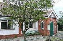
The Church of England parish church of St James, built in 1859 of brick and flint, is towards the southern end of the village. It was designed by architect, Samuel Sanders Teulon.[14] The interior is brick with patterns formed by the use of differently coloured brick courses and complimentary colour stone embellishments.
Leckhampstead has a village hall used for voluntary and social gatherings.
One public house is in the village: The Stag.
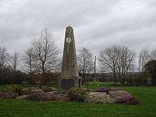
There is a war memorial on the triangular village green. It comprises an obelisk on a plinth with two clock faces, one facing north and one facing south, which incorporate various types of ammunition in them. The surrounding chains are from a battleship that took part in the Battle of Jutland and they are supported on spent shell cases.[15] It was given Grade II listed status in may 2016, legally protecting it from unauthorised modification or removal.[16]
The Hangman's Stone is a boundary stone about a mile south of the middle of the village at grid reference SU431748. It gets its name from a local tale which tells of a sheep rustler who was carrying a stolen sheep over his shoulder with a rope held around his neck. Feeling tired the thief sat on a stone beside the road and fell asleep. The sheep, in struggling to get free, hanged the man by the rope that had remained around his neck.[15] The stone has given its name to the road which passes it, Hangman's Stone Lane, which leads to the village of Boxford.
The hamlet of Hill Green has six listed buildings, all in the initial category of Grade II. All are homes, the earliest dates to the 18th century.[17]
Leckhampstead Thicket
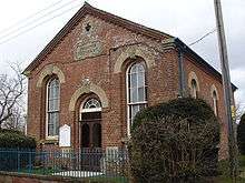
Leckhampstead Thicket is a hamlet between Leckhampstead and Chaddleworth (grid reference SU429769). There is a number of thatched or slated cottages of which two are listed and a Primitive Methodist chapel, dated 1874, rebuilt from one of 1830, which has not been in use as a chapel for a number of years.[4]
Economy
The physical economy within the parish is mainly related to agriculture. For a time such as in the early 20th century brick works employed some sons of the village at the Oare works, part of Chieveley.[4] Today access to the M4 corridor is within a few miles south of the village by a junction close to Chieveley. A high proportion of the 16–74 age range in the 2011 census were self-employed.
Demography
| Output area | Homes owned outright | Owned with a loan | Socially rented | Privately rented | Other | km² roads | km² water | km² domestic gardens | Usual residents | km² |
|---|---|---|---|---|---|---|---|---|---|---|
| Civil parish | 64 | 42 | 24 | 8 | 3 | 0.060 | 0,000 | 0,160 | 343 | 7.13 |
At the same census 238 people in Leckhampstead were aged 16–74 whose economic activity was divided as follows, per their responses:
| Output area | Employed | Part-time employed | Self-employed | Retired | Looking After Home or Family | Student | Sick or disabled | Unemployed (active/inactive) |
|---|---|---|---|---|---|---|---|---|
| Civil parish | 40.8% | 10.9% | 16.8% | 10.9% | 7.6% | 2.1% | 2.5% | 5.4% |
| Nationally | 38.6% | 13.7% | 9.8% | 13.7% | 4.4% | 3.4% | 4.0% | 6.6% |
References
- 1 2 3 4 Key Statistics: Dwellings; Quick Statistics: Population Density; Physical Environment: Land Use Survey 2005
- ↑ Newbury and District bus timetable 107
- ↑ "National Monuments Record".
- 1 2 3 4 5 6 7 William Page and P.H. Ditchfield (eds) (1924). "Parishes: Chieveley". A History of the County of Berkshire: Volume 4. Institute of Historical Research. Retrieved 9 December 2014.
- ↑ Historic England. "Details from listed building database (1013220)". National Heritage List for England. Round barrow 670m east of Rowbury Farm, Scheduled Ancient Monument.
- ↑ "National Monuments Record (Monument No. 233492)".
- ↑ "National Monuments Record (Monument No. 233509)".
- ↑ "National Monuments Record (Leckhampstead Old Church)".
- ↑ "The Domesday Book Online: Berkshire D-M". Retrieved 18 January 2008.
- ↑ Domesday Book: A Complete Translation. London: Penguin Books. 2003. p. 142. ISBN 0-14-143994-7.
- ↑ Domesdaymap entry Retrieved 9 December 2014
- ↑ "National Monuments Record (Leckhampstead Park)".
- ↑ Historic England. "Details from listed building database (1117169)". National Heritage List for England. Leckhampstead manor farm house, manor lane.
- ↑ Archbishops' Council. "St James, Leckhampstead". Church of England. Retrieved 18 January 2008.
- 1 2 Billing, Joanna, ed. (1999). The Hidden Places of The Thames Valley. Travel Publishing Ltd. pp. 6–7. ISBN 1-902007-34-4.
- ↑ Historic England. "Details from listed building database (1433388)". National Heritage List for England. Retrieved 4 August 2016.
- ↑ Historic England. "Details from listed building database (1135859)". National Heritage List for England. Ivydene, Historic England. "Details from listed building database (1117165)". National Heritage List for England. Hill Green House
External links
![]() Media related to Leckhampstead, Berkshire at Wikimedia Commons
Media related to Leckhampstead, Berkshire at Wikimedia Commons