Woolhampton
| Woolhampton | |
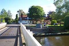 Woolhampton Swing Bridge |
|
 Woolhampton |
|
| Area | 3.87 km2 (1.49 sq mi) |
|---|---|
| Population | 886 (2011 census)[1] |
| – density | 229/km2 (590/sq mi) |
| OS grid reference | SU5767 |
| Civil parish | Woolhampton |
| Unitary authority | West Berkshire |
| Ceremonial county | Berkshire |
| Region | South East |
| Country | England |
| Sovereign state | United Kingdom |
| Post town | READING |
| Postcode district | RG7 |
| Dialling code | 0118 |
| Police | Thames Valley |
| Fire | Royal Berkshire |
| Ambulance | South Central |
| EU Parliament | South East England |
| UK Parliament | Newbury |
Coordinates: 51°23′49″N 1°10′37″W / 51.397°N 1.177°W
Woolhampton is a village and civil parish in West Berkshire, England. The village straddles the London to Bath (A4) road between the towns of Reading (8 miles) and Newbury (6 miles). The village homes are clustered and are on the northern side of the plain of the River Kennet, with the Berkshire Downs rising through the fields and woods of the village northwards.[2]
Geography
Besides the A4, the London to Exeter (via Taunton) railway line and the Kennet and Avon Canal also pass through the village. Woolhampton is served by Midgham railway station in the village. The railway station was originally known as Woolhampton railway station but, according to local legend, was renamed Midgham railway station (after the village of Midgham, one mile west-northwest) in order to avoid possible confusion with the similarly named Wolverhampton railway station.[3]
The A4 road forms the main street of the village. An unclassified road runs to the south, towards the village of Brimpton. This crosses the railway line by the station on a level crossing, followed shortly afterwards by a swing bridge across the river and canal (which share a common channel at this point). Woolhampton Lock lies just to the west. Two other unclassified roads leave the village to the north, climbing into the Berkshire Downs.[2]
Because of its location on the Bath road, Woolhampton was well known for its coaching inns. Only one of these survive on the main road, the Angel after the Falmouth Arms closed in 2014 and converted to residential property. A second public house, the Rowbarge, is, as its name suggests, situated alongside the Kennet and Avon Canal next to the swing bridge.[4]
On the higher land some half mile to the north of the village is the adjacent settlement of Upper Woolhampton, which contains both Woolhampton (St Peter's) Church and the village school. A further half mile to the north, but still within the civil parish, is the Benedictine Douai Abbey community, and its now-closed Douai School. Between Douai Abbey and the village is the historic Woolhampton House, which now houses Elstree School, a preparatory school that moved to Woolhampton from the London suburb of Elstree during the Second World War.[2][4][5]
The civil parish of Woolhampton includes the village of Woolhampton, the adjacent settlement of Upper Woolhampton, and the rural area to the north, east and south of the village. It has a parish council, and also lies in the West Berkshire local government district and the Newbury parliamentary constituency.[2][6]
The Woolhampton Reed Bed, a Site of Special Scientific Interest, lies alongside the River Kennet within the parish and to the south east of the village. The dense reed bed, with smaller areas of tall fen vegetation and carr woodland, is notable for its nesting passerine bird populations and for the diversity of insects it supports.[7]
Upper Woolhampton in Bucklebury has long been in that larger parish ecclesiastically and secularly. it is on the same wide escarpment and has approximately the same amount of housing and population as Woolhampton itself.
Nearest places
 |
Upper Bucklebury, Bucklebury | Upper Woolhampton, Bucklebury | Beenham | |
| Brimpton | |
Aldermaston Wharf, Aldermaston | ||
| ||||
| | ||||
| Midgham | Wasing, Brimpton | Aldermaston |
Demography
| Output area | Homes owned outright | Owned with a loan | Socially rented | Privately rented | Other | km² roads | km² water | km² domestic gardens | Usual residents | km² |
|---|---|---|---|---|---|---|---|---|---|---|
| Civil parish | 137 | 125 | 30 | 43 | 18 | 0.076 | 0.054 | 0.173 | 886 | 3.87 |
See also
Notes and references
- References
- 1 2 Key Statistics: Dwellings; Quick Statistics: Population Density; Physical Environment: Land Use Survey 2005
- 1 2 3 4 Ordnance Survey (2006). OS Explorer Map 158 - Newbury & Hungerford. ISBN 0-319-46352-4.
- ↑ "Basingstoke's Railway History in Maps". Christopher J. Tolley. 2001. Archived from the original on 2007-05-20. Retrieved 2007-09-13.
- 1 2 "Berkshire History : Woolhampton". Nash Ford Publishing. 2004. Retrieved 2007-09-13.
- ↑ "Our History". Elstree School. Retrieved 2007-09-13.
- ↑ "Woolhampton Parish Council's Web Site". Retrieved 2007-09-13.
- ↑ "Woolhampton Reed Bed" (PDF). English Nature. Retrieved 2006-09-22.
- Notes
External links
![]() Media related to Woolhampton at Wikimedia Commons
Media related to Woolhampton at Wikimedia Commons