Boundary marker

A boundary marker, border marker, boundary stone, or border stone is a robust physical marker that identifies the start of a land boundary or the change in a boundary, especially a change in direction of a boundary.[1] There are several other types of named border markers, known as pillars, obelisks, and corners.[1] Border markers can also be markers through which a border line runs in a straight line to determine that border.[1] They can also be the markers from which a border marker has been fixed.[1]
Purpose
According to Josiah Ober, boundary markers are "a way of imposing human, cultural, social meanings upon a once-undifferentiated natural environment." Boundary markers are linked to social hierarchies, since they derive their meaning from the authority of a person or group to declare the limits of a given space of land for political, social or religious reasons. Ober notes that "determining who can use parcels of arable land and for what purpose, has immediate and obvious economic implications."[2]
Many borders were drawn along invisible lines of latitude or longitude, which often created a need to mark these borders on the ground, as accurately as possible, using the technology of the day.[1] Advances in GPS technology have shown that there are many borders inaccurately marked on the ground.[1]
Boundary markers have often been used to mark critical points on political boundaries, i.e. those between countries, states or local administrations, but have also been used to mark out the limits of private landholdings, especially in areas where fences or walls are impractical or unnecessary.
In developed countries the use of markers for land ownership has in many places been replaced by maps and land ownership registration. Boundary markers are not legal markers in Western countries and may have troublesome legal effects.[3] However, boundary markers have legal meaning in Japan, and are generally installed across the country.[4] Markers are still used extensively for marking international borders, which are traditionally classified into two categories: natural boundaries, correlating to topographical features such as rivers or mountain ranges, and artificial boundaries, which have no obvious relation to topography. The latter category includes borders defined by boundary markers such as stones and walls.[5] International boundary markers are placed and can be maintained by mutual agreement of the bordering countries.
Construction
Boundary markers, traditionally, were often made of stone, but later many have been made with concrete or a mixture of materials.[6] They are typically placed at a notable or especially visible point. Many are inscribed with relevant information such as the abbreviation of the boundary holder and often a date.[1]
History
Asia
China
The oldest known boundary stone in China is from Jiangsu Province. Dating from 12 A.D., it bears the inscription "the sea area from Jiaozhou Bay to the east of Guixan county belongs to Langya Shire and the waters from the south of Guixan county to the east of the estuary of Guanhe River belongs to Donghai Shire."[7] More recently, the border between Russia and China was formally demarcated with boundary stones as the result of the Treaty of Kiakhta in 1727.[8] In the nineteenth century, stones were used to outline the limits of the International Settlement in Shanghai.[9]
Thailand
In ancient Thailand, sacred boundary stones called Sema Hin delimited Buddhist temple precincts. In some cases they feature inscriptions recounting the history of the temple;[10] others were carved with wheels of the law,[11] while some specimens consist of unfinished stone.[12] In addition to temples, sema could enclose statues of Buddha or sacred mounds.[11]
Near East and Africa
Palestine
According to B. S. Jackson, stones were put in place in ancient Israel to "mark the boundary of a territory (public or private), and to seek to deter potential violators of that boundary through the use of threats."[13] The Hebrew Bible contains a strict prohibition against the unauthorized displacement or removal of boundary markers.[14]
Egypt
An example of boundary markers in ancient Egypt were the boundary stelae of Akhenaten. They defined the limits of the sacred city of Akhet-Aten, built by Akhenaten as the center of the Aten religious cult which he founded. Egyptologists categorize the stelae based on whether they are inscribed with the "Earlier Proclamation," a general explanation of why the location was selected and how the city would be designed, or the "Later Proclamation," which provides additional details about the perimeters of the city.[15]
Europe

Greece
The earliest reference to a boundary stone in Greek literature is in the Iliad, which describes the goddess Athena using one as a projectile. Boundary stones, known as horos, could be made of either carved or undressed stones, and were typically inscribed with the Greek word horos. One such stone was used to indicate the edge of the Athenian agora.[2] The practice of separating areas of land with boundary stones, though common, was widely considered by classical writers to be a violation of the principle of communal land ownership.[16]
Rome
In ancient Roman religion, the god Terminus was worshiped as the patron god of boundary markers.[17] Ovid, in a hymn directed to the god, wrote: "O Terminus, whether thou art a stone or a stump buried in the field, … thou dost set bounds to people and cities and vast kingdoms".[18] Numa Pompillius made the first Roman law requiring boundary stones around private property and instituting capital punishment for anyone found guilty of moving these stones.[19]
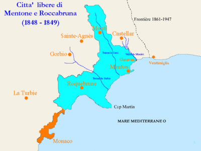
Monaco
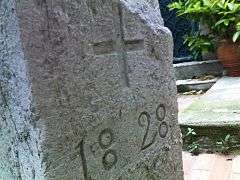
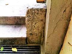
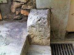
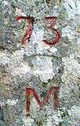
In 1828, the Principality of Monaco and the Kingdom of Piedmont-Sardinia established a physical border with 91 boundary stones, each numbered 1 to 91, running along the border from present-day Fontvieille to Menton-Garavan.[20] Prior to 1848, the Principality of Monaco included the villages of Roquebrune, Monti, Garavan and Menton. Of the original 91 boundary stones only 12 remain: 6 within the Principality of Monaco, 3 in Roquebrune-Cap-Martin, and 3 in Menton. The boundary stones numbered 9, 12, 15, and 31 are located in Monaco. Another stone has been cast in concrete in the Sainte-Cécile area of Monaco thus rendering its number illegible. Stone number 55, originally located in Roquebrune, was given as a gift from the city of Roquebrune to the Principality of Monaco and is now located in Monaco's city hall. Stones numbered 56, 57, and 58 are located in Roquebrune. Stones numbered 62, 71, and 73 are located in Menton. All the boundary stones have three engraved sides: one side with their individual numbers (1 to 91), one side with the letter "M" indicating Monaco's territory, and one side with a cross (+) indicating the Kingdom of Piedmont-Sardinia's territory. The cross represents the coat of arms of the House of Savoy, rulers of Piedmont-Sardinia.


Western Australia
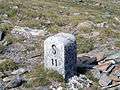
The history of marking the Western Australian border on the ground states that the "Austral Pillar" and the "Deakin Pillar" are points used to determine their position east of Greenwich and then fix a border from, in this case used to determine the line of the 129th meridian east longitude, as the Western Australian border.[1] The Deakin Obelisk and the Kimberley Obelisk in Australia are used in a slightly different way, in that a line is run north and south through a point on the obelisks, formed by a copper plug embedded into the top centre of the concrete obelisks.[1] The "corners" in Australia, such as Cameron Corner, Haddon Corner, Poeppel Corner, and Surveyor Generals Corner, are where multiple borders meet or a border changes direction.[1]
United States
Hawaii
The basic unit of the ancient Hawaiian land division system was the ahupua'a, a self-sustaining agricultural district.[21] The places where a road crossed the border of an ahupua'a were marked with distinctive altars, known as ahu or (stone) piles. These altars served not only as boundary markers but also as sites for the performance of religious rituals related to land taxation.[22] C. J. Lyons, an early surveyor of Hawaii,[23] recorded that „[u]pon this altar at the annual progress of the akua makahiki (year god) was deposited the tax paid by the land whose boundary it marked, and also an image of a hog, puaa, carved out of kukui wood and stained with red ochre. … [F]rom this came the name, ahupuaa“.[24] Naturally occurring landscape features were also used as points of reference for district borders.[25]
Washington, D.C.
The original boundaries of the District of Columbia were marked using boundary stones. These were made of saw-cut sandstone blocks and stood two feet high when set in the ground. Ten boundary stones were placed along each side of the 100 square mile (259 square kilometer) district of Columbia. Although the original surveyors intended each side to be ten miles (16 kilometers) long, their measurements were often inaccurate, resulting in the sometimes significant misplacement of stones and the overall skewing of the District boundaries.[26] Some of these discrepancies are intentional, because the ground at the exact mile point was covered in water; “in such cases,” Andrew Ellicott, the leader of the surveying crew, noted in 1793, “the stones are placed on the nearest firm ground and the true distance in miles and poles is marked on them”.[27]
Information engraved on the stones includes the number (1 through 10) of the stone within the sequence on that side of the District, the date of placement, and the words "Jurisdiction of the United States." In the twentieth century, the Daughters of the American Revolution voluntarily took responsibility for preserving the stones, which had fallen victim to vandalization and urban development.[27] In the late 1990s renewed interest in the boundary stones led to increased preservation efforts by the DAR and other organizations.[28]
Other States
In 1773, a Franciscan friar named Francisco Palou erected the first boundary marker between Alta and Baja California. Commissioned by the Spanish Crown, it consisted of a cross made from alder wood and placed standing upright on a rock.[29] In the British colonies, milestones were shipped from England to mark the Mason–Dixon line.[30] A block cut from sandstone was placed at the intersection of Wyoming, Colorado and Utah in 1879,[31] and stone posts were used along the western border of South Dakota.[32] Boundaries were occasionally resurveyed and boundary stones replaced or restored, depending on their condition.[33]
Examples of historic boundary markers
Dreieckiger Pfahl, Germany
See also
- Bai Sema, which delimit sacred areas
- Dreiherrenstein, historical tripoints of the Holy Roman Empire
- Milestone, mile peg or kilometre sign
- Survey marker
- Triangulation station (Trig Point – Australia/NZ/UK)
- Tripoint
Gallery

 Border stone at Passo San Giacomo between Val Formazza in Italy and Val Bedretto in Switzerland
 Two French-Swiss border boundary markers.
 Boundary stone of the original District of Columbia set in 1792 and now marking the boundary between Washington, D.C., and Maryland in the United States.
 German forest boundary stone set up in 1754; it marks the end of a line of boundary stones between the Hanoverian state forest and woods held in common by local farmers. The border was marked in 1750 by order of George II of Great Britain who was also Elector of Hannover at that time.
 Boundary marker (also banishing pole) in Schardam, the Netherlands, showing the coat of arms of Hoorn.
 Modern boundary marker on the 49th parallel north designating the border between the United States and Canada.
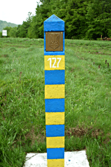 Typical border marker of Ukraine.
References
| Wikimedia Commons has media related to Boundary stones. |
- 1 2 3 4 5 6 7 8 9 10 Porter, John (June 1990). AN HISTORICAL PERSPECTIVE – Longitude 129 degrees east, and why it is not the longest, straight line in the world. National Perspectives – 32nd Australian Surveyors Congress Technical Papers 31 March – 6 April 1990. Canberra: The Institution: Eyepiece – Official Organ of The Institution of Surveyors, Australia, W.A. Division. pp. 18–24.
- 1 2 Ober, Josiah. "Greek Horoi: Artifactual Texts and the Contingency of Meaning." Methods in the Mediterranean: Historical and Archaeological Views of Texts and Archaeology. Ed. David. B. Small. Leiden: Brill, 1995. URL: http://www.stanford.edu/group/dispersed_author/docs/GreekHoroi.pdf
- ↑ "Cadastral Information For GIS Specialists - Case Of The Misplaced Boundary Marker". Fairview-industries.com. Retrieved 2013-07-27.
- ↑ Civil Law 229; more information Archived 3 January 2013 at the Wayback Machine.
- ↑ Cukwurah, A. Oye (1967). The Settlement of Boundary Disputes in International Law. Manchester: Manchester University Press. pp. 16–17.
- ↑ "1921 WA-NT Border Determinations". Kununurra Historical Society Inc. Retrieved 9 January 2012.
- ↑ 潘其. "The boundary stone of Han Dynasty in Suma Bay - China - Chinadaily.com.cn". www.chinadaily.com.cn. Retrieved 2016-03-03.
- ↑ Perdue, Peter C. (2009). China Marches West: The Qing Conquest of Central Asia. Cambridge, MA: Harvard University Press. p. 289.
- ↑ Bickers, Robert & Jonathan J. Howlett (2015). Britain and China, 1840-1970: Empire, Finance and War. London: Routledge. p. 190.
- ↑ Phetsanghan, Phairot, Songkoon Chantachon and Boonsom Yodmalee (2009). "Sema Hin Isan, the Origin of the Temple Boundary Stones in Northeast Thailand". The Social Sciences. 4: 186–190. Retrieved March 3, 2016.
- 1 2 Woodward, Hiram, W. (2003). The Art and Architecture of Thailand: From Prehistoric Times Through the Thirteenth Century. Leiden: Brill. p. 104.
- ↑ Woodward, Hiram W. (2003). The Art and Architecture of Thailand: From Prehistoric Times Through the Thirteenth Century. Leiden: Brill. p. 100.
- ↑ Clements, Ronald E. (Ed.) (1991). The World of Ancient Israel: Sociological, Anthropological and Political Perspectives. Cambridge: Cambridge University Press. p. 190.
- ↑ Cukwurah, A. Oye (1967). The Settlement of Boundary Disputes in International Law. Manchester: Manchester University Press. p. 10.
- ↑ Murnane, William J. (1993). The Boundary Stelae of Akhenaten. London: Kegan Paul Int. pp. 1–2.
- ↑ Needham, Joseph (1956). Science and Civilization in China: Volume 2, History of Scientific Thought. Cambridge: Cambridge University Press. p. 127.
- ↑ Cukwurah, A. Oye (1967). The Settlement of International Boundary Disputes in International Law. Manchester: Manchester University Press. p. 11.
- ↑ Robillard, Walter G.; Donald A. Wilson & Curtin M. Brown (2009). Brown's Boundary Control and Legal Principles. Hoboken, NJ: John Wiley. p. 6.
- ↑ Cukwurah, A. Oye (1967). The Settlement of Boundary Disputes in International Law. Manchester: Manchester University Press. p. 11.
- ↑ http://bornes.frontieres.free.fr/index.htm
- ↑ Oaks, Robert (2003). Hawaii: A History of the Big Island. Charleston: Arcadia Publishing. p. 13.
- ↑ Lucas, Paul Nahoa (1995). A Dictionary of Hawaiian Legal Land Terms. Honolulu: University of Hawaii Press. p. 4.
- ↑ Gonschor, Lorenz & Kamanamaikalani Beamer. (2014). "Toward an Inventory of Ahupua'a in the Hawaiian Kingdom: A survey of Nineteenth and early Twentieth-Century Cartographic and Archival Records of the Island of Hawai'i.". The Hawaiian Journal of History. 48.
- ↑ Valerio, Valeri (1985). Kingship and Sacrifice: Ritual and Society in Ancient Hawaii. Chicago: University of Chicago Press. p. 155.
- ↑ Crocombe, R. G. (1987). Land Tenure in the Pacific. Suva Fiji: University of the South Pacific. p. 26.
- ↑ Woodward, Fred E. (1907). "A Ramble Along the Boundary Stones of the District of Columbia with a Camera". Historical Society of Washington, D.C.: 63–87.
- 1 2 Nye, Edwin Darby (1971). "Revisiting Washington's Forty Boundary Stones". Historical Society of Washington, D.C.: 740–51.
- ↑ "Boundary Stones of Washington, D.C.". www.boundarystones.org. Retrieved 2016-03-03.
- ↑ Hendry, George W. (1926). "Francisco Palou's Boundary Marker". California Historical Society Quarterly: 321–27.
- ↑ Van Zandt, Franklin K. (1976). Boundaries of the United States and the several States: with miscellaneous geographic information concerning areas altitudes and geographic centers. United States Government Printing Office. p. 139.
- ↑ Van Zandt, Franklin K. (1976). Boundaries of the United States. United States Government Printing Office. p. 143.
- ↑ Van Zandt, Franklin K. (1976). Boundaries of the United States. United States Government Printing Office. p. 136.
- ↑ Van Zandt, Franklin K. (1976). Boundaries of the United States. United States Government Printing Office. p. 71.