Lakshadweep
| Lakshadweep ലക്ഷദ്വീപ് | ||
|---|---|---|
| Union Territory | ||
| ||
 | ||
| Coordinates: 10°36′N 72°36′E / 10.6°N 72.6°ECoordinates: 10°36′N 72°36′E / 10.6°N 72.6°E | ||
| Country |
| |
| Formation | 1 November 1956 | |
| Capital | Kavaratti | |
| Government | ||
| • Administrator | Farooq Khan IPS (Retd.) | |
| • MP | Mohammed Faizal P. P. (Nationalist Congress Party) | |
| Area | ||
| • Total | 32 km2 (12 sq mi) | |
| Area rank | 36th | |
| Population (2011 Census) | ||
| • Total | 65,473 | |
| • Density | 2,000/km2 (5,300/sq mi) | |
| Languages[1] | ||
| • Official | Malayalam | |
| • Additional official | English | |
| Ethnicity | ||
| • Ethnic groups |
≈84.33% Malayali ≈15.67% Mahls | |
| Time zone | IST (UTC+5:30) | |
| ISO 3166 code | IN-LD | |
| Vehicle registration | LD | |
| No. of districts | 1 | |
| Largest city | Andrott | |
| HDI |
0.796 | |
| HDI Year | 2005 | |
| HDI Category | high | |
| Website |
www | |
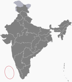
Lakshadweep (/ləkˈʃɑːdwiːp/, ![]() Lakṣadvīp , Lakshadīb), formerly known as the Laccadive, Minicoy, and Aminidivi Islands (/ˌlækədaɪv ˌmɪnᵻkɔɪ/ & /ˌæmᵻnˈdiːvi/),[2] is a group of islands in the Laccadive Sea, 200 to 440 kilometres (120 to 270 mi) off the south western coast of India. The archipelago is a Union Territory and is governed by the Union Government of India. They were also known as Laccadive Islands, although geographically this is only the name of the central subgroup of the group. Lakshadweep comes from "Lakshadweepa", which means "one hundred thousand islands" in Sanskrit.[3][4] The islands form the smallest Union Territory of India: their total surface area is just 32 km2 (12 sq mi). The lagoon area covers about 4,200 km2 (1,600 sq mi), the territorial waters area 20,000 km2 (7,700 sq mi) and the exclusive economic zone area 400,000 km2 (150,000 sq mi). The region forms a single Indian district with ten sub divisions. Kavaratti serves as the capital of the Union Territory and the region comes under the jurisdiction of Kerala High Court. The islands are the northernmost of the Lakshadweep-Maldives-Chagos group of islands, which are the tops of a vast undersea mountain range, the Chagos-Laccadive Ridge.[5]
Lakṣadvīp , Lakshadīb), formerly known as the Laccadive, Minicoy, and Aminidivi Islands (/ˌlækədaɪv ˌmɪnᵻkɔɪ/ & /ˌæmᵻnˈdiːvi/),[2] is a group of islands in the Laccadive Sea, 200 to 440 kilometres (120 to 270 mi) off the south western coast of India. The archipelago is a Union Territory and is governed by the Union Government of India. They were also known as Laccadive Islands, although geographically this is only the name of the central subgroup of the group. Lakshadweep comes from "Lakshadweepa", which means "one hundred thousand islands" in Sanskrit.[3][4] The islands form the smallest Union Territory of India: their total surface area is just 32 km2 (12 sq mi). The lagoon area covers about 4,200 km2 (1,600 sq mi), the territorial waters area 20,000 km2 (7,700 sq mi) and the exclusive economic zone area 400,000 km2 (150,000 sq mi). The region forms a single Indian district with ten sub divisions. Kavaratti serves as the capital of the Union Territory and the region comes under the jurisdiction of Kerala High Court. The islands are the northernmost of the Lakshadweep-Maldives-Chagos group of islands, which are the tops of a vast undersea mountain range, the Chagos-Laccadive Ridge.[5]
As the islands do not have any aboriginal groups, different views have been postulated by the scholars about the history of habitation on these islands. Archaeological evidence support the existence of human settlement in the region around 1500 BC. The islands have long been known to sailors, as indicated by an anonymous reference from the first century AD to the region in Periplus of the Erythraean Sea. The islands were referenced also in the Buddhist Jataka stories of the 6th century BC. The arrival of Muslim missionaries around 7th century led to the advent of Islam in the region. During the medieval period the region was ruled by the Chola dynasty and Kingdom of Cannanore. The Portuguese arrived around 1498 and were upstaged by 1545. The region was then ruled by the Muslim house of Arakkal, followed by Tipu Sultan. On his death in 1799 most of the region passed on to the British and with their departure the Union Territory was formed in 1956.
Ten of the islands are inhabited. At the 2011 Indian census the population of the Union Territory was 64,473. The majority of the indigenous population is Muslim and most of them belong to the Shafi School of the Sunni Sect. The islanders are ethnically similar to the Malayali people of the nearest Indian state of Kerala. Most of the population speaks Malayalam with Mahi (or Mahl) being the most spoken language in Minicoy island. The islands are served by an airport on the Agatti island. The main occupation of the people is fishing and coconut cultivation, with tuna being the main item of export.
History
Several views have been postulated about the history of the habitation of the islands as they do not have any aboriginal groups. A mention of the region in the Periplus of the Erythraean Sea, by an anonymous author, is one of the earliest references.[6] There are references to the control of the islands by the Cheras in the Sangam Patiṟṟuppattu. Local traditions and legends attribute the first settlement on these islands to the period of Cheraman Perumal, the last Chera king of Kerala.[7] The oldest inhabited islands in the group are Amini, Kalpeni Andrott, Kavaratti and Agatti. Archaeological evidence suggests that Buddhism prevailed in the region during the 5th-6th century CE.[6] According to popular tradition, Islam was brought to Lakshadweep by an Arab named Ubaidulla in 661 CE. His grave is located on the island of Andrott.[8] During the 11th century, the islands came under the rule of the Late Cholas[6] and subsequently the Kingdom of Cannanore.[9]
In the 16th century the Portuguese ruled the seas between Ormuz and the Malabar Coast -and down to Ceylon. As early as 1498 they took control of the archipelago (called Laquedivas by them), later on to exploit coir production, until the islanders expelled them in 1545. In the 17th century, the islands came under the rule of Ali Rajahs/Arakkal Bheevi of Kannur, who received them as a gift from the Kolathiris. The islands are also mentioned in great detail in the stories of the Arab traveller Ibn Batuta.[10]
The Aminidivi group of islands (Androth, Amini, Kadmat, Kiltan, Chetlath and Bitra) came under the rule of Tipu Sultan in 1787. They passed to British control after the Third Anglo-Mysore War and were attached to South Canara. The rest of the islands came under the suzerainty of the Arakkal family of Cannanore in return for a payment of annual tribute. The British took over the administration of those islands for non-payment of arrears. These islands were attached to the Malabar district of the Madras Presidency during the British Raj.[11]
Independent India
On 1 November 1956, during the reorganization of Indian states, the Lakshadweep islands were separated from Madras organized into a separate union territory for administrative purposes. The new territory was called 'Laccadive, Minicoy, and Amindivi Islands before adopting the Lakshadweep name on 1 November 1973.[12]
To safeguard India's vital shipping lanes to the Middle East, and the growing relevance of the islands in security considerations, an Indian Navy base, INS Dweeprakshak, was commissioned on Kavaratti island.[13]
A DX-pedition (VU7AG) by amateur radio operators was run on Agatti Island during November 2013.
Geography

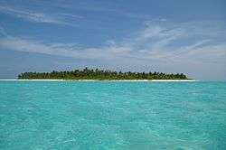
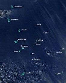

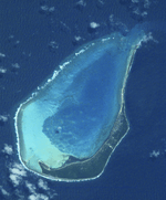
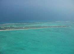
Lakshadweep is an archipelago of twelve atolls, three reefs and five submerged banks, with a total of about thirty-nine islands and islets. The reefs are in fact also atolls, although mostly submerged, with only small unvegetated sand cays above the high-water mark. The submerged banks are sunken atolls. Almost all the atolls have a northeast-southwest orientation with the islands lying on the eastern rim, and a mostly submerged reef on the western rim, enclosing a lagoon. It has 10 inhabited islands, 17 uninhabited islands, attached islets, 4 newly formed islets and 5 submerged reefs.[14]
The main islands are Kavaratti, Agatti, Minicoy, and Amini. The total population of the territory is 60,595 according to the 2001 census. Agatti has an airport with direct flights from Kochi.
India's Coral Islands
The Aminidivi subgroup of islands (consisting of Amini, Keltan, Chetlat, Kadamat, Bitra and Perumal Par) and the Laccadive subgroup of islands (comprising mainly Androth, Kalpeni, Kavaratti, Pitti and Suheli Par), both subgroups having a submarine connection between them through Pitti Bank. Together with Minicoy Island, a lonely atoll located at the southern end of the 200 km broad Nine Degree Channel, they form the Coral Islands of India in the Arabian Sea. All these islands have been built up by corals and have fringing coral reefs very close to their shores.[15]
Two banks further north are not considered part of the group:
The atolls, reefs and banks are listed from north to south in the table:
Flora and fauna
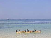
The Lakshadweep Archipelago forms a terrestrial ecoregion together with the Maldives and the Chagos.[16] It has over 600 species of marine fishes, 78 species of corals, 82 species of seaweed, 52 species of crabs, 2 species of lobsters, 48 species of gastropods, 12 species of bivalves, 101 species of birds.[17] It is one of the four coral reef regions in India.[18] The corals are a major attraction for the tourist. Pitti Island, is an important breeding place for sea turtles and for a number of pelagic birds such as the brown noddy (Anous stolidus), lesser crested tern (Sterna bengalensis) and greater crested tern (Sterna bergii).[19] The island has been declared a bird sanctuary.[20]
The region does not have a rich flora and almost all the plants can be found on the mainland of India. There is also an absence of forest in the region. Nearly 400 species of flowering plants have been documented, including three species of sea grasses Cymodocia isoetifolia, Syringodium isoetifolium and Thalassia hemprichii, other angiosperms as Pandanus, Heliotropium foertherianum, Tournefortia argentea and Pemphis acidula as well as fungi, algae, lichens are also found. The common flora of the coral sands include coconut groves and coastal shrubs as Pemphis acidula, Cordia subcordata, Scaevola taccada, Thespesia populnea, Suriana maritima, Dodonaea viscosa, Guettarda speciosa and seaweeds such as sea lettuces, Codium and Hypena.[17][21]
Government and administration
_ISLANDS_c.2000_passenger_plate_-_Flickr_-_woody1778a.jpg)
Lakshadweep forms a single Indian district and is governed by an administrator appointed by the President of India under article 239 of the constitution. The present administrator is Mr. Farooq Khan IPS [22] There are 10 Sub Divisions of the territory. In Minicoy and Agatti the Sub Division is under a Deputy Collector while in the remaining 8 islands developmental activities are coordinated by Sub Divisional Officers. The Collector cum Development Commissioner who is also the District Magistrate oversees matters coming under District Administration, such as revenue, land settlement, law and order. The District Magistrate is assisted by one Additional District Magistrate and Ten Executive Magistrates with respect to enforcement of law and order. Administrator in his capacity as Inspector General of Lakshadweep Police has command and control of the Lakshadweep Police. Administration Secretariat is in Kavaratti.[23] The union territory comes under the jurisdiction of the Kerala High Court at Kochi along with a system of lower courts.[24] The territory elects one member to the Lok Sabha (lower house of the Parliament of India).[25]
Demographics
According to the 2011 census Lakshadweep has a population of 64,429,[26] roughly equal in number to that of the Marshall Islands.[27] This gives it a ranking of 627th among the 640 districts in India.[26] The district has a population density of 2,013 inhabitants per square kilometre (5,210/sq mi).[26] Its population growth rate over the decade 2001-2011 was 6.23%.[26] Lakshadweep has a sex ratio of 946 females for every 1000 males,[26] and a literacy rate of 92.28%.[26]
Most people of Lakshadweep are descendants of migrants from the Malabar Coast of southwest India and the islanders are ethnically similar to coastal Kerala's Malayali people. More than 93% of the population who are indigenous, are Muslims and the majority of them belong to the Shafi School of the Sunni Sect. The southernmost and second largest island of Minicoy has an ethnically Mahls population that are native to the Maldives.[14][28]
Religion

The inhabitants of Lakshadweep were known to practice different religious customs. Then Islam was propounded by the Sheikh Ubaidullah.[30]
There are several festivals that have originated in the island of Lakshadweep to mark the eminence of Islam. Eid-Ul-Fitr, Muharram, Bakra Eid and Milad-Un-Nabi are the prominent occasions when the people of the island gather in various mosques to commemorate the holy sermons of the various prophets.
Religion of Lakshadweep is characterized by certain unusual festivals too that are found in the core ethnic groups of the place. Moulood is one such religious event when the islanders offer prayers to the divine power and eat in groups. The festival of Ratheeb is another uncommon occasion which originated in the Kavaratti region of Lakshadweep. The grave of Sheikh Kasim, one of the respected saints of Islam is praised during Ratheeb by the people of the island to gather his holy blessings.
The Sunni branch of Islam is the predominant faith.
Languages
The principal languages of Lakshadweep are Malayalam, Jeseri (Dweep Bhasha) and Mahl.[32] The people of all the northern islands speak a dialect of Malayalam with Tamil and Arabic similar to Arwi influenced by extensive trade activities of these people. The people of Minicoy, the southernmost atoll, speak Mahl, a variant of Divehi language spoken in the Maldives.
Malayalam with Malayalam script was introduced as the official language of Lakshadweep during the British raj. Previously a type of Arabic script (Arabi Malayalam) was used for the language. The policy was continued by the Indian government. Malayalam serves as a link language on the islands including on the Mahl dominated Minicoy Island.[33] The dances here include:-Lava Dance,Kolkali dance & Parichakli Dance.
Economy
Lakshadweep's gross state domestic product for 2004 is estimated at US$ 60 million at current prices. There is little economic inequality in Lakshadweep and the poverty index is low. Coconut fibre extraction and production of fibre products is Lakshadweep's main industry. There are five coir fibre factories, five production demonstration centres and seven fibre curling units run by the government of India. These units produce coir fibre, coir yarn, curled fibre and corridor mattings.[34]
Fisheries
Lakshadweep comprises the only coral atolls of the country. With a vast lagoon of 4,200 km2 (1,600 sq mi), it has territorial waters of 20,000 km2 (7,700 sq mi), Exclusive Economic Zone (EEZ) of 4,00,000 lakh (400,000 km2 [150,000 sq mi]) and coastal line of about 132 kilometres (82 mi). There is an estimation of about one lakh tonnes (100,000 tonnes [110,000 tons]) of tuna and tuna-like fishes and about an equal quantity of shark in the sea around Lakshadweep. Fishing is the main livelihood of the islanders.[35] Freshly caught tuna is processed by drying it in the sun after cooking and smoking. The resultant product, known as 'mas', are popular products exported from these islands to southeast Asian countries.[36] Eleven workshops in islands and two boat building yards cater to the needs of fishermen. There are 375 boats in operation in Lakshadweep.[37]
Tourism
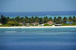
Due to its isolation and scenic appeal, Lakshadweep was already known as a tourist attraction for Indians since 1974.[38] This brings in significant revenue, which is likely to increase. Since such a small region cannot support industries, the government is actively promoting tourism as a means of income in Bangaram and Kadmat islands. Bangaram is projected as a major destination for international tourism.[39] Marine fauna are plentiful. Water sports activities such as scuba diving, wind surfing, snorkelling, surfing, kayaking, canoeing, water skiing, sportfishing, yachting and night-voyages into the sea are quite popular activities among tourists. Tourists flock to these islands throughout the year except during the South-west monsoon months when seas are extremely rough. Government has also proposed to set up two customs clearance check-in offices so that tourists can directly enter these islands instead of getting permission from nearest customs office in Kochi, which is 260 nautical miles (300 mi; 480 km) from these islands. These will be the smallest customs offices in India. Tourism is expected to get big boost after this as these islands lie on one of the busiest cruise way.
Desalination
| Animal | Butterfly fish[40][41] | |
|---|---|---|
| Bird' | Noddy tern[40][41] | |
| Tree | Bread fruit[40][41] | 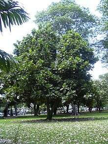 |
| Flower | Not designated |
A low-temperature thermal desalination plant opened on Kavaratti in 2005, at a cost of ₹50 million (€922,000). The experimental plant, which uses the temperature difference between warm surface seawater and much colder seawater at 500m depth to generate potable water as well as energy, was slated to produce 100,000 litres/day of potable water from seawater.[42][43] Production costs in 2005 were ₹220-250/m³ (€4.1-4.6/m³); the cost was supposed to drop to ₹30-60/m³ (€0.55-1.11/m³) with increased capacity.[44]
The technology was developed by the National Institute of Ocean Technology. It can be used to produce drinking water and also for power generation and air conditioning. In addition, the deep seawater contains extra nutrients for fish, an important source of food and income for the local population. The government plans to set up desalination plants with a capacity of 10 million litres/per day on all islands and coastal areas.[42] In 2009, the NIOT announced plans to build plants on Minicoy, Agatti and Andrott.[45]
Transport and tourism

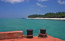
Agatti Aerodrome on Agatti Island is the only airport in Lakshadweep. Air India Regional, a subsidiary of the state-owned carrier, serves Agatti and flies to Kochi on the mainland. Kingfisher Airlines, had flights connecting Kochi and Bangalore to Agatti before the airline ceased operations. The other islands are linked by the Pawan Hans helicopter or boat service.[46] Six ships connect Kochi and Lakshadweep: MV Kavaratti, MV Aminidivi, MV Minicoy, MV Arabian Sea, MV Lakshadweep Sea and MV Bharath Seema. [47]
Tourists need a permit to visit the islands; foreign nationals are not permitted to visit certain islands.[48] According to the current alcohol laws of India, alcoholic beverage consumption is not permitted in the Lakshadweep Archipelago except on Bangaram Island.[49]
See also
References
- ↑ "50th Report of the Commissioner for Linguistic Minorities in India" (PDF). 16 July 2014. p. 109. Retrieved 6 November 2016.
- ↑ "The Laccadive, Minicoy and Aminidivi Islands (Alteration Of Name Act), 1973". The Indian Lawyer. 26 August 1973. Retrieved 9 May 2012.
- ↑ "Lakshadweep". encyclopedia.com. Archived from the original on 27 January 2010. Retrieved 1 August 2012.
- ↑ "About Lakshadweep". lakshadweeptourism.nic.in. Retrieved 1 August 2012.
- ↑ "Origin and compensation of Chagos-Laccadive ridge, Indian ocean, from admittance analysis of gravity and bathymetry data". Earth and Planetary Science Letters. 105: 47–54. 1991-07-31. Bibcode:1991E&PSL.105...47A. doi:10.1016/0012-821X(91)90119-3. Retrieved 2015-02-25.
- 1 2 3 "Marine investigations in the Lakshadweep Islands, India.". thefreelibrary.com. Retrieved 1 August 2012.
- ↑ “Lakshadweep & It's People 1992-1993” Planning Department, Govt. Secretariat, Lakshadweep Administration, Kavaratti. Page: 12.
- ↑ "History". lakshadweep.nic.in. Retrieved 1 August 2012.
- ↑ "Lakshadweep". Encyclopædia Britannica, Inc. Retrieved 2 August 2012.
- ↑ "South Asia : Journal of South Asian Studies : Volume 2 : Sources towards a history of the Laccadive Islands". Tandfonline.com. 1979. Retrieved 25 February 2015.
- ↑ Logan, William (1887). Malabar Manual. New Delhi: Asian Education Services. p. 2. ISBN 81-206-0446-6.
- ↑ "Lakshadweep". World Statesmen. Retrieved 8 October 2016.
- ↑ "Navy commissions full-scale station in Lakshadweep". The Hindu. 1 May 2012. Retrieved 9 May 2012.
- 1 2 "Location,Area and Population". lakshadweep.nic.in. Retrieved 1 August 2012.
- ↑ `INDIA: A Physical Geography`(ISBN 81-230-0656-X),1968,Publications Dn, Ministry of I&B, Govt. of India. page:74.
- ↑ "Maldives-Lakshadweep-Chagos Archipelago tropical moist forests". Terrestrial Ecoregions. World Wildlife Fund.
- 1 2 "Biodiversity and Environment Protection" (PDF). Lakshadweep Development Report. Planning Commission of India. Retrieved 3 August 2012.
- ↑ "Lakshadweep Development Report" (PDF). Department of Environment and Forests (Union Territory of Lakshadweep). Retrieved 3 August 2012.
- ↑ Archived 12 January 2012 at the Wayback Machine.
- ↑ "The Wild Life (Protection) Act, 1972". Department of Environment and Forests (Union Territory of Lakshadweep). Retrieved 5 August 2012.
- ↑ Rao, T.A. & J.L. Ellis, Flora of Lakshadweep Islands off the Malabar coast, peninsular India, with emphasis on phytogeographical distribution of plants. Journal of Economic and Taxonomic Botany 19:235-250. 1995
- ↑ "Lakshadweep Panchayats Regulations, 1994". lakshadweep.nic.in. Retrieved 1 August 2012.
- ↑ "Administrative Setup". lakshadweep.nic.in. Retrieved 1 August 2012.
- ↑ "Judicial Setup". lakshadweep.nic.in. Retrieved 1 August 2012.
- ↑ "Our Parliament". parliamentofindia.nic.in. Retrieved 1 August 2012.
- 1 2 3 4 5 6 "District Census 2011". Census2011.co.in. 2011. Retrieved 30 September 2011.
- ↑ US Directorate of Intelligence. "Country Comparison: Population". Retrieved 1 October 2011.
Marshall Islands 67,182 July 2011 est.
- ↑ "Lakshadweep". borderdarshan.com. Retrieved 1 August 2012.
- ↑ "Population by religion community - 2011". Census of India, 2011. The Registrar General & Census Commissioner, India. Archived from the original on 25 August 2015.
- ↑ "Kiltan Island". Lakshadweep.nic.in. Retrieved 25 February 2015.
- ↑ "Commissioner Linguistic Minorities (originally from Indian Census, 2001)". Archived from the original on 8 October 2007.
- ↑ Archived 5 February 2011 at the Wayback Machine.
- ↑ "The Muslim Tribes of Lakshadweep Islands: An Anthropological Appraisal of ... - Makhan Jha - Google Books". Books.google.com. Retrieved 2015-02-25.
- ↑ "Report of the Working Group on Improvement of Banking Services in the Union Territory of Lakshadweep" (PDF). Rbidocs.rbi.org.in. Retrieved 25 February 2015.
- ↑ "FISHERIES". lakshadweep.nic.in. Retrieved 1 August 2012.
- ↑ "Department of Fisheries-About Us". lakshadweep.nic.in. Retrieved 1 August 2012.
- ↑ "Fisheries". lakshadweep.nic.in. Retrieved 1 August 2012.
- ↑ "Tourism in Lakshadweep". Lakshadweeptourism.nic.in. 1988-10-22. Retrieved 2015-02-25.
- ↑ Archived 10 May 2011 at the Wayback Machine.
- 1 2 3 "Symbols of Lakshadweep". knowindia.gov.in. Retrieved 17 October 2013.
- 1 2 3 "Lakshadweep Key Indicators" (PDF). Retrieved 17 October 2013.
- 1 2 "World's first ever low temperature thermal desalination plant opened at Kavaratti" (Press release). Ministry of Science and Technology (India). 23 May 2005. Retrieved 1 August 2012.
- ↑ "One Million Litre Per Day (1 MLD) Barge Mounted Desalination Plant" (Press release). Ministry of Science and Technology (India). 18 April 2007. Retrieved 1 August 2012.
- ↑ "Desalination: India opens world's first low temperature thermal desalination plant" (Press release). Press Information Bureau, Government of India. 23 May 2005. Archived from the original on 22 July 2012. Retrieved 3 August 2012.
- ↑ "City institute plans to develop manned submersibles". The Hindu. 19 November 2009. Retrieved 1 August 2012.
- ↑ "Kochi to Agatti Flights and their Schedule". Mapsofindia.com. 2014-09-08. Retrieved 2015-02-25.
- ↑ "Means of Transport". Union Territory of Lakshadweep. Retrieved 1 August 2012.
- ↑ "Entry Permits". Union Territory of Lakshadweep. Retrieved 25 February 2015.
- ↑ "Introduction to Lakshadweep Islands". The New York Times. Retrieved 1 August 2012.
External links
| Wikimedia Commons has media related to Lakshadweep. |
 Lakshadweep travel guide from Wikivoyage
- Lakshadweep a Photo Essay
 |
Arabian Sea | | ||
| Arabian Sea | |
Lakshadweep Sea | ||
| ||||
| | ||||
| Indian Ocean |
Countries and territories bordering the Indian Ocean | ||
|---|---|---|
| Africa |
|  |
| Asia |
| |
| Other | ||