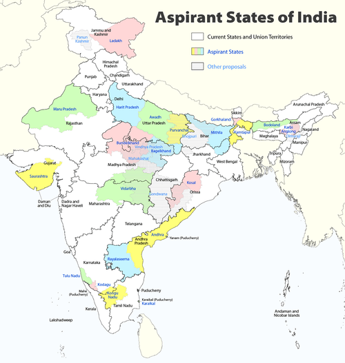
Proposed states and territories of India
The creation of new states and territories in India is a power reserved solely for the President of India. The President can do so by announcing new states, separating territory from an existing state or by merging two or more states or parts thereof.[1] In addition to the existing twenty nine states and seven union territories[2] some new states and territories of India have been proposed to be established over time.
History
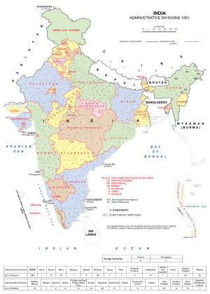
Before independence, India was divided into British-administered provinces and nominally autonomous princely states, which were governed by the British administration. After the partition of India, some of these administrative divisions became part of the Dominion of Pakistan, whilst the remaining states and provinces formed the Dominion of India. The colonial system of administration continued until 1956 when the States Reorganisation Act abolished the provinces and princely states in favour of new states which were based on language and ethnicity.
Several new states and union territories have been created out of existing states since 1956. The Bombay Reorganisation Act split the Bombay State into the present day states of Gujarat and Maharashtra on May 1, 1960 on linguistic basis.[3] The state of Nagaland was created on December 1, 1963.[4] The Punjab Reorganisation Act of 1966 carved out a new Hindi-speaking state of Haryana from the southern districts of Punjab state,[5] transferred the northern districts to Himachal Pradesh and designated a union territory around Chandigarh, the shared capital of Punjab and Haryana.[6]
Statehood was conferred upon Himachal Pradesh on January 25, 1971,[7] and to Manipur, Meghalaya and Tripura on January 21, 1972.[8] The Kingdom of Sikkim joined the Indian Union as a state on April 26, 1975.[9] In 1987, Arunachal Pradesh and Mizoram became states on February 20, followed by Goa on May 30 of the same year. Goa's northern exclaves of Daman and Diu became a separate union territory.[10]
Three new states were created in November 2000: Chhattisgarh (November 1) was created out of eastern Madhya Pradesh;[11] Uttaranchal (9 November), which was later renamed Uttarakhand,[12] was created out of the mountainous districts of northwest Uttar Pradesh;[13] and Jharkhand (November 15) was created out of the southern districts of Bihar.[14] On 2 In June 2014, Telangana was separated from Andhra Pradesh as the 29th state of the union.[15]
Assam
Bodoland
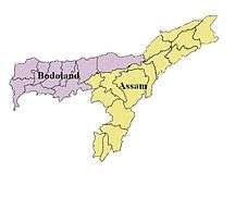
The agitation for the creation of a separate Bodoland state resulted in an agreement between the Indian Government, the Assam state government and the Bodo Liberation Tigers Force. According to the agreement made on February 10, 2003, the Bodoland Territorial Council, an entity subordinate to the government of Assam, was created to govern four districts covering 3082 Bodo-majority villages in Assam.[16][17] Elections to the council were held on May 13, 2003, and Hagrama Mohilary was sworn in as the chief of the 46-member council on June 4.[18]
Karbi Anglong
Karbi Anglong is one of the 35 districts of Assam. Karbi Anglong was previously known as Mikir Hills. It was part of the Excluded Areas and Partially Excluded Areas (the present North East India) in British India. The British Indian government had never included this area under their government's jurisdiction. Thereby, no government development work or activity were done, nor any tax levied from the hills including Karbi Anglong. The first memorandum for a Karbi homeland was presented to Governor Reid on October 28, 1940 by Semsonsing Ingti and Khorsing Terang at Mohongdijua.[19] The Karbi leaders were then,a part of the All Party Hill Leaders' Conference (APHLC) which was formed on July 6, 1960.[20] The movement again gained momentum when the Karbi Anglong District Council passed a resolution demanding a Separate State in 1981. Then again from 1986 through the leadership of Autonomous State Demand Committee (ASDC), demanded Autonomous statehood of Karbi Anglong & Dima Hasao under Article 244(A). In 2002, the Karbi Anglong Autonomous Council passed another resolution to press for the demand of statehood. Several other memoranda were submitted at different times by several organisations. The demand for a separate state turned violent on July 31, 2013 when student demonstrators set government buildings on fire. Following the incident, the elected leaders of Karbi Anglong jointly submitted a memorandum to the Prime Minister of India demanding a separate State.
Bihar
Bhojpur
There have been demands for a Bhojpur state, comprising the Bhojpuri speaking districts of western Bihar, eastern Uttar Pradesh and northern Chhattisgarh and Jharkhand.[21][22][23]
Mithila
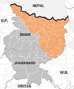
Mithila (Devnagri: मिथिला, mithilā Tirhuta: মিথিলা) is a proposed state which would cover the Maithili speaking regions of Bihar and Jharkhand. There are 24 Maithili-speaking districts in Bihar: Araria, Begusarai, Bhagalpur, (Banka), Darbhanga, East Champaran Katihar, Khagaria, Kishanganj, Madhepura, Madhubani, Muzaffarpur, Purnea, Saharasa, Samastipur, Sheohar, Sitamarhi, Supaul, Vaishali, and West Champaran, Munger, Jamui. There are six Maithili-speaking districts in Jharkhand: Deoghar, Dumka, godda, Jamtara, Pakaur, and Sahebganj. There is no consensus on a proposed capital though Barauni, Darbhanga and Muzaffarpur have been suggested as candidate cities for the proposed capital.
Gujarat
Bhilistan State
The establishment of Bhilistan (Hindi: भिलिस्तान) has been a demand for over 30 years.[24] The 1999 book Untouchable Dalits in Modern India by SM Michael reported the demand for Bhilistan[25] In 2012, The Times of India reported that the Bhilistan movement has been gaining ground in the tribal regions of Bharuch.[26] The Daily News and Analysis reported in 2013 that the formation of Telangana state has reignited hopes for the demand of statehood to this region, comprising of the tribal dominated parts of Gujarat, Rajasthan, Madhya Pradesh and Maharashtra.[24]
Kutch State
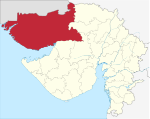
Kutch State or Cutch State (Gujrati: જિલ્લો), covering three districts, Kutch district, Great Rann of Kutch district and Little Rann of Kutch district of Gujrat, is an aspirant, both as an independent state and as a combined Saurashtra. Sourashtra State and Kutch State existed as separate states from 1947 to 1956.[27][28] They were Part-B and Part-C states of India respectively. They were later merged with Bombay state following the States Reorganisation Act.[29] They became part of Gujarat after the bifurcation of Bombay state on May 1, 1960 following the Mahagujarat Movement. Some people demand a return of statehood to Saurashtra and Kutch citing slow development of the regions.[30] Apart from these two separate state-hood demands there is as demand for separate Bhilistan state.[27][24][31]
At the time of the integration of the princely state of Kutch with India in 1947, the accession was done on the condition that Kutch would retain the status of a separate state. It enjoyed this status till 1960, when a separate state of Gujarat was carved out of Maharashtra and Kutch was merged with it. The main reason behind a separate state is cultural and geographical distance from Gandhinagar. In 1960, Kutch was promised an autonomous development board under Article 371(2) of the Constitution, which never came into existence due to lack of political will. Water from river Narmada does not reach the farms of this region.[32]
Saurashtra State
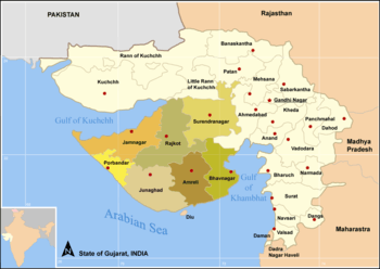
The Saurashtra state (Gujrati and Hindi: સૌરાષ્ટ્ર) movement for separate Saurashtra state was initiated in 1972 by advocate Ratilal Tanna, who was a close aide of former Prime Minister Morarji Desai. As per the Saurashtra Sankalan Samiti, more than 300 organisations across the Saurashtra region support the demand of the separate State. The Samiti also claims that compared to other parts of Gujarat, Saurashtra is underdeveloped. Lack of better water supply to the region, lack of job opportunities and subsequent youth migration have been cited as major reasons for the demand of statehood.[27][24][33] Sourashtra is linguistically different from the rest of the state with its Sourashtra dialect being in use.[34]
Karnataka
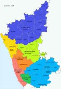
Karnataka is most probably divided into Karu Nadu, Kalyana Karnataka, Tulu Nadu, Mysuru, Konkana and Vijayanagara as well as Sanskrutamani.
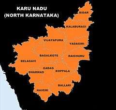
Kalyana Karnataka
Kalyana Karnataka is a Kannada speaking region of Hyderabad State ruled by the Nizams of Hyderabad until 1948. After merging with the Indian union, the region became a part of the Hyderabad State. The Hyderabad-Karanataka region comprises Bidar, Yadgir, Raichur, Koppal Bellary and Gulbarga districts. The Kalyana Karnataka region is the second largest arid region in India. [35][36][37][38]
Kalyana Karnataka was a term coined by noted Kannada activist Dr. Chidananda Murthy.[39][40] The region is also called the Gulbarga division. As recent as October 2014 there have been demands from organisations fighting for the cause of satehood to the region.[41] and Hyderabad-Karnataka Abhivradhi Horata Samithi.
Karu Nadu
Karu Nadu, locally known as North Karnataka, is a geographical region consisting of mostly semi-arid plateau ranging from an elevation of 300 to 730 metres (980 to 2,400 ft).This region constitutes the northern part of the South Indian state of Karnataka. It is drained by the Krishna River and its tributaries the Bhima, Ghataprabha, Malaprabha, and Tungabhadra. Karu Nadu lies within the Deccan thorn scrub forests ecoregion, which extends north into eastern Maharashtra. It includes the districts of Bagalkot, Belgaum, Bellary, Bidar, Bijapur, Dharwad, Gadag, Gulbarga, Haveri, Koppal, Raichur and Yadagiri district. Major cities in the region are Belgaum, Bellary, Bidar, Bijapur, Chikodi, Dharwad, Gokak, Gulbarga, Hospet, Hubli and Ranebennur.
Tulu Nadu
Tulu Nadu is a border region between the states of Karnataka and Kerala in southern India. The demand for a separate state is based on a distinct culture and language (Tulu, which does not have official status), and neglect of the region by the two state governments.[42][43] To counter these demands and accusations, the Karnataka and Kerala state governments have created the Tulu Sahitya Academy to preserve and promote Tuluva culture.[44] The proposed state would comprise three existing districts; Dakshina Kannada and Udupi from Karnataka, and Kasaragod district from Kerala.
Jammu and Kashmir
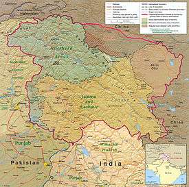
Jammu
Although Jammu is part of the disputed Kashmir region, it is not geographically a part of the Kashmir valley or the Ladakh region. The Jammu Division is inhabited by the native Dogra people who are historically, culturally, linguistically, and geographically connected with the historical Jammu of the Punjab region and the Pahari regions of the former Punjab Hills States that now constitute the state of Himachal Pradesh.[45][46][47] Most of Jammu and Kashmir's Hindu population lives in the Jammu region and are closely related to the Punjabi-speaking peoples of Punjab; many speak Dogri,[45] earlier considered a dialect of Punjabi and now is one of the official languages of India.
Kashmir
The proposed Kashmir state comprises the Kashmir valley region in Jammu & Kashmir. Ethnic Kashmiri leaders have called for the trifurcation of the Jammu and Kashmir state citing it as the only solution to fix the Kashmir conflict in India. Kashmiri writer and opinion leader Ghulam Nabi Khayal has given his support for an independent Union Territory of Ladakh and for the Jammu region to be merged into Punjab or given a separate statehood.[48]
Ladakh
Ladakh, comprising a sizeable chunk of eastern Jammu and Kashmir, has asked for a Union Territory status as part of a desire to protect its culture. People mainly speak Ladakhi. The Ladakh Autonomous Hill Development Council (LAHDC), was originally created in 1993 to serve the Ladakhi people's demand for separation from Jammu and Kashmir by becoming a Union Territory. In early October 2015, the Bharatiya Janata Party's election manifesto for the Ladakh Autonomous Hill Development Council, Leh election included a promise for Union Territory status.[49] The BJP went on to get 18 out of the 24 seats it contested, a clear majority.[50]
Madhya Pradesh
Baghelkhand, Bundelkhand and Vindhya Pradesh
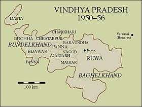
Vindhya Pradesh is a former state of India. It occupied an area of 23,603 sq. miles.[51] It was created in 1948, shortly after the Indian independence, from the territories of the princely states in the eastern portion of the former Central India Agency. It was named for the Vindhya Range, which runs through the center of the province. The capital of the state was Rewa. It lay between Uttar Pradesh to the north and Madhya Pradesh to the south, and the enclave of Datia, which lay a short distance to the west, was surrounded by the state of Madhya Bharat.
Vindhya Pradesh was merged into Madhya Pradesh in 1956, following the States Reorganisation Act.[29] In 2000, Sriniwas Tiwari, ex-speaker of the Madhya Pradesh assembly, called for nine districts to be separated from Madhya Pradesh to create a new state of Vindhya Pradesh, although this was rejected by the Chief Minister of Madhya Pradesh.[52] Separate Bundelkhand and Baghelkhand states instead of a single Vindhya Pradesh is advocated as well to accommodate the districts claimed by these regions from neighboring state of Uttar Pradesh.[53][54]
Gondwana and Mahakoshal
Mahakoshal is a region which lies in the upper or eastern reaches of the Narmada River valley in the Indian state of Madhya Pradesh. Cities and districts of the region include Jabalpur, Katni, Narsinghpur, Mandla, Dindori, Satna, Seoni and Chhindwara. The largest city and a possible capital is Jabalpur. Organisations such as Mahakaushal Mukti Morcha and Bharatiya Janashakti have demanded separate statehood for the region.[55][56]
It is alleged that though the Mahakoshal region is rich in minerals, forests, water and land resources, related industries were set up in nearby states.[56] Also, the region has a distinct cultural identity owing to Jabalpur city, known as the Sanskardhani (Cultural Capital) of the State, one of the oldest towns of Central India. Culturally and socially, the Mahakoshal region differs greatly from the neighbouring Vindhya Pradesh. One of the key reasons for this is said to be that large parts of Mahakoshal were under direct British rule from the nineteenth century onwards, turning it into a relatively progressive, modern and liberal area and infusing democratic values into its body politic. Casteism and feudalism are said to be not as deeply rooted in this region as they are in Vindhya Pradesh.[57]
A parallel demand for a state of Gondwana from the same Mahakoshal region of Madhya Pradesh has arisen owing to the fact that vast areas of Mahakoshal were ruled by Gond kings and even today, Mandla, Chinndwara, Dindori, Seoni and Balaghat have a predominantly Gond tribal population. Tribals constitute 64 per cent of the total population of Dindori district. For Mandla, the corresponding figure is 57 per cent. The Gondwana Gantantra party (GGP) was established in 1991, with the objective to struggle for the creation of a separate Gondwana State comprising regions that were ruled by Gonds. The Gondwana Gantantra party (GGP) has since divided into numerous factions such as Rashtriya Gondwana party and Gondwana Mukti Dal.[57]
Malwa
There have been sporadic demands for a separate Malwa state with the probable capital at Indore. The region includes the Madhya Pradesh districts of Agar, Dewas, Dhar, Indore, Jhabua, Mandsaur, Neemuch, Rajgarh, Ratlam, Shajapur, Ujjain, and parts of Guna district and Sehore, and the Rajasthan districts of Jhalawar and parts of Banswara and Pratapgarh.
The main language of Malwa is Malvi, although Hindi is widely spoken in the cities. This Indo-European language is subclassified as Indo-Aryan. The language is sometimes referred to as Malavi or Ujjaini. Malvi is part of the Rajasthani branch of languages; Nimadi is spoken in the Nimar region of Madhya Pradesh and in Rajasthan. The dialects of Malvi are, in alphabetical order, Bachadi, Bhoyari, Dholewari, Hoshangabadi, Jamral, Katiyai, Malvi Proper, Patvi, Rangari, Rangri and Sondwari. A survey in 2001 found only four dialects: Ujjaini (in the districts of Ujjain, Indore, Dewas and Sehore), Rajawari (Ratlam, Mandsaur and Neemuch), Umadwari (Rajgarh) and Sondhwari (Jhalawar, in Rajasthan). About 55% of the population of Malwa can converse in and about 40% of the population is literate in Hindi, the official language of the Madhya Pradesh state.[58]
Maharashtra
Khandesh
Khandesh is a region of central India, which forms the northwestern portion of Maharashtra state.[59] Khandesh was the region demarcated as a boundary after which Dakkhan a.k.a. Deccan started. The Khandesh state was founded and ruled by the Faruqi dynasty with its capital at Burhanpur (now in Madhya Pradesh). The state covered the area of the today's Jalgaon, Dhule, Nandurbar districts of Maharashtra state and Burhanpur district of Madhya Pradesh state. The terms "Khandesh" and "Deccan" thus connote historical and political affiliations, as well as geographical zones. Khandesh lies on the Northwestern corner of the Deccan plateau, in the valley of the Tapi River, and is bound to the north by the Satpura Range, to the east by the Berar (Vidarbha) region, to the south by the Hills of Ajanta, belonging to the Marathwada region of Maharashtra, and to the west by the northernmost ranges of the Western Ghats, and beyond them the coastal plain of Gujarat.
After India's independence in 1947, Bombay province became Bombay state, which in 1960 was divided into the linguistic states of Maharashtra and Gujarat. During the formation of the State of India, Burhanpur became the part of the state Of Madhya Pradesh, and in 1960, East Khandesh became Jalgaon district, and West Khandesh became Dhule of the Maharashtra State.
Konkan
Konkan is a rugged section of the western coastline of India. It consists of the coastal districts of Maharashtra, Goa and Karnataka. The ancient sapta-Konkan is a slightly larger region described in the Sahyadrikhanda which refers to it as "Parashuramakshetra". The proposed konkan state includes the districts of Ratnagiri and Sindhudurg of Maharashtra, north and south districts of Goa and north kanara district of Karnataka.[60]
Marathwada
Marathwada (IPA:Marāṭhvāḍā) is one of the five regions in the Indian state of Maharashtra. The region coincides with the Aurangabad Division of Maharashtra. Marathwada cam under the rule of the Nizam of Hyderabad, which later became the princely state of Hyderabad, under the suzerainty of British India. Subsequently, through Operation Polo, a “police action” on September 17, 1948, the Indian army annexed Hyderabad to India and on November 1, 1956, Marathwada was transferred from Hyderabad State to Bombay State. On May 1, 1960, Bombay state was divided into Maharashtra and Gujarat states, Marathwada becoming a part of the former.
Vidarbha
Vidarbha is a region that comprises the Amravati and Nagpur divisions of eastern Maharashtra. The State Reorganisation Act of 1956 placed Vidarbha in Bombay State. Shortly after this, the States Reorganisation Commission recommended the creation of Vidarbha state with Nagpur as the capital, but instead it was included in Maharashtra state, which was formed on May 1, 1960. Support for a separate state of Vidarbha had been expressed by Loknayak Bapuji Aney and Brijlal Biyani Vidarbha. The demand for the creation of a separate state are based on allegations of neglect by the Maharashtra state government. Jambuwantrao Dhote led a popular struggle for Vidarbha statehood in the 1970s. Two politicians, N. K. P. Salve and Vasant Sathe, have led attempts to bring about a state of Vidarbha in recent times.
NCR (National Capital Region)
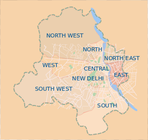
Delhi/ˈdɛli/ , Meerut , Baghpat, Muzaffarnagar, Gurgaon, Sonipat, Faridabad, Ghaziabad, Noida and Greater Noida form the National Capital Region, with a population of about 22 million.[61][62] The political administration of Delhi more closely resembles that of a state than a union territory, with its own legislature, high court and an executive council of ministers headed by a Chief Minister. New Delhi is jointly administered by the Union government and the local government of Delhi. The previous National Democratic Alliance government introduced a bill in Parliament in 2003, to grant full statehood to Delhi, but the legislation was not passed.[63]
North East
Kukiland

The Kuki Hills was an independent hill country during the pre-British colonial period. It was merged by the colonial power into Manipur. The Kuki people, under the leadership of Kuki State Demand Committee[64] demand statehood for the Kuki areas in Manipur, i.e. Sadar Hills, Chandel, Churachandpur districts and some parts of Ukhrul and Tamenglong districts, to be reconstituted as Kukiland.[65]
Odisha
Kosal
The Kosal region is the entire Western Odisha area located in Odisha state, between 19° 37’- 23° N latitude and 82° 28’- 85° 22’ E longitudes comprising the districts of Sundargarh, Jharsuguda, Debagarh, Sambalpur, Bargarh, Sonepur, Boudh, Bolangir, Nuapada, Kalahandi, Nabarangpur, Aathmallik sub-division of Angul district and Kashipur block of Rayagada district. It is surrounded by Jharkhand state on the north, on the east by the dist of Keonjhar, Angul and Kandhamal; on the south by Rayagada, Koraput and on the west by Chhattisgarh state. This geographical area comes under the Western Odisha Development Council.
Tamil Nadu
Kongu Nadu
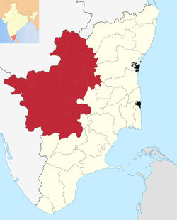
There have been demands for the creation of a separate state of Kongu Nadu (also called Kongadesam, the ancient Chera Kingdom), comprising the regions of western Tamil Nadu, parts of southern Karanataka and central-east Kerala with its capital at Coimbatore, based on demography, culture, linguistics and other factors. There have been claims that the Kongu Nadu region has often been ignored by successive governments in spite of being the largest contributor to the state's economy. A number of political outfits including Kongunadu Makkal Desia Katchi, Kongu Vellala Goundergal Peravai and Tamil Nadu Kongu Ilaignar Peravai are active in the region claiming to fight for the rights of the region.[66][67][68][69]
Uttar Pradesh
At least four states have been proposed to be carved out of Uttar Pradesh.[70]
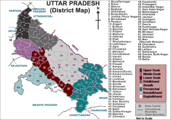
Awadh
The population of proposed Awadh state, consisting of Awadhi speaking districts of central Uttar Pradesh, would be approximately 50 million people with an area of approximately 75,000 km2 and Lucknow as the capital.
Braj Pradesh/Harit Pradesh/Paschimanchal
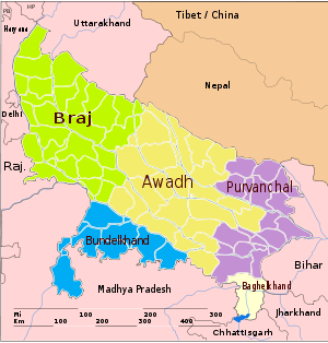
Harit Pradesh is a proposed state, which would comprise 22 districts of Western Uttar Pradesh, currently forming six divisions – Agra, Aligarh, Bareilly, Meerut, Moradabad, and Saharanpur. The most prominent advocate for the creation of the new state is Ajit Singh, the leader of the Rashtriya Lok Dal party. Mayawati also supported the formation of Harit Pradesh in December 2009.
There is another demand within the same region - Braj Pradesh, consisting of Agra division and Aligarh division from Uttar Pradesh and districts of Bharatpur and Gwalior from Rajasthan and Madhya Pradesh. The proposed capital would be in Agra.[71][72] So far, Braj has remained as a historical and cultural region, rather than a political entity. Language of Braj is Braj Bhasha.
Bundelkhand
Bundelkhand comprises parts of Uttar Pradesh and Madhya Pradesh. While the Bahujan Samaj Party government under Chief Minister Mayawati proposed in 2011, the creation of Bundelkhand from seven districts of Uttar Pradesh, organisations such as Bundelkhand Mukti Morcha (BMM) want it to include six districts from Madhya Pradesh as well.[73] Uma Bharati of the Bharatiya Janata Party promised a separate state of Bundelkhand within three years if her party was voted to power, during campaigning for the 2014 Loksabha Elections at Jhansi.[74] Similar promise was made by Congress leader Pradeep Jain Aditya during these elections.[75]
Since the early 1960s there has been a movement for establishing a Bundelkhand state for promoting development of the region. Bundelkhand is geographically the central part of India covering part of Madhya Pradesh and part of Uttar Pradesh. In spite of being rich in minerals, the people of Bundelkhand are very poor and the region is underdeveloped and underrepresented in state and central politics.[53][76] Agrarian crisis and farmer's suicides is also cited as reason for separate statehood.[77]
Purvanchal
Purvanchal (Hindi: पूर्वांचल, Urdu: پُورواںچل) is a geographic region of north-central India, which comprises the eastern end of Uttar Pradesh state. It is bounded by Nepal to the north, Bihar state to the east, Bagelkhand region of Madhya Pradesh state to the south, the Awadh region of Uttar Pradesh to the west. Purvanchal comprises three divisions – Awadhi region in the west, Bhojpuri region in the east and the Baghelkhand region in the south. The most commonly spoken language in Purvanchal is Bhojpuri. Purvanchal area is represented by 23 Members of Parliament to the lower house of Indian Parliament, and 117 legislators in the 403 member Uttar Pradesh state assembly or Vidhan Sabha.[78] Districts-Azamgarh, Ballia, Chandauli, Deoria, Ghazipur, Gorakhpur, Jaunpur, Kushinagar, Maharajganj, Mau, Mirzapur, Sant Kabir Nagar, Sant Ravidas Nagar, Siddharth Nagar, Varanasi.
As a fallout of the movement for Telangana , then state chief minister Mayawati, proposed on December 13, 2009, to carve out a separate state of Purvanchal[79] out of Uttar Pradesh with either Allahabad or Varanasi as its capital. The ongoing movement for Purvanchal is spearheaded by politician Amar Singh.
West Bengal
Gorkhaland
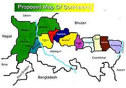
Gorkhaland (Nepali: गोर्खाल्याण्ड) is a proposed state covering areas inhabited by the ethnic Gorkha (Nepali) people, namely Darjeeling hills and Dooars in the northern part of West Bengal.[80] The movement for Gorkhaland has gained momentum in the line of ethno-linguistic-cultural sentiment of the people who desire to identify themselves as Gorkha.[81]
The demand for a separate administrative region has existed since 1907, when the Hillmen's Association of Darjeeling submitted a memorandum to the Morley-Minto reforms committee.[82] After Indian independence, the Akhil Bharatiya Gorkha League (ABGL) was the first political party from the region to demand greater identity for the Gorkha ethnic group and economic freedom for the community. In 1980, the Pranta Parishad of Darjeeling wrote to the then Prime Minister of India, Indira Gandhi, with the need to form a state for the Gorkhas.
The movement for a separate state of Gorkhaland gained serious momentum during the 1980s, when a violent agitation was carried out by Gorkha National Liberation Front (GNLF) led by Subhash Ghising. The agitation ultimately led to the establishment of a semiautonomous body in 1988 called the Darjeeling Gorkha Hill Council (DGHC) to govern certain areas of Darjeeling district. However, in 2008, a new party called the Gorkha Janmukti Morcha (GJM) raised the demand for a separate state of Gorkhaland once again.[83] In 2011, GJM signed an agreement with the state and central governments for the formation of Gorkhaland Territorial Administration, a semiautonomous body that replaced the DGHC in the Darjeeling hills.[84]
Kamtapur
Kamtapur lies in the northern parts of West Bengal.[85] The proposed state consists of the districts of Koch Behar, Jalpaiguri, and southern plains of Darjeeling, including Siliguri city.
Sindh/Sindhi Pradesh
In an interview with All India Radio, Sindhi political leader G.M. Syed advocated the independence of Sindh from Pakistan to form Sindhudesh, or confederation of Sindh with India.[86] In a speech, Prime Minister of India Narendra Modi told the Sindhi diaspora in India that Sindh returning to India is an accomplishable dream.[87]
According to Gul Agha, India is a country that is well suited to the secular Sufi mindset of the Sindhi people.[88] There were an estimated 3.5 million Sindhis in India, when the number of Sindhis in Pakistan was roughly 32 million.[89]
There is a separate movement initiated by Gyan Hemnani[90] for the creation a new Sindhi linguistic state called "Sindhi Pradesh" (Sindhi Linguistic Territory (S.L.T.))[91] by merging Kutch district of Gujarat with the Jaisalmer, Jalore and Barmer districts of Rajasthan. The total population of this proposed sindhi state will be around 6 million.
Smaller proposals
- Karaikal district is one of the four districts of Puducherry, lying 150 km (93 mi) south of Pondicherry. There is a movement advocating the formation of a separate union territory because of a perceived lack of development compared to the rest of Puducherry.[92]
- Konkan, comprising the Konkani-speaking areas of Raigad, Ratnagiri, Thane, Mumbai, Navi Mumbai and Sindhudurg districts in Maharashtra.[93][94]
See also
References
- ↑ "Articles 2 and 3 of the Constitution of India" (PDF). Government of India. Retrieved 23 May 2013.
- ↑ "First Schedule of the Constitution of India" (PDF). Government of India. Retrieved 23 May 2013.
- ↑ J.C. Aggarwal and S.P. Agrawal, editors, Uttarakhand: Past, Present, and Future (New Delhi: Concept Publishing, 1995), p89-90
- ↑ Nagaland History & Geography-Source india.gov.in
- ↑ The Punjab Reorganisation Act 1966
- ↑ "State map of India". Travel India guide. Retrieved 2013-06-17.
- ↑ Statehood Himachal Pradesh
- ↑ "Snapshot of North Eastern States" (PDF). Retrieved 3 September 2016.
- ↑ Bhatt, S. C. (1 January 2005). "Land and People of Indian States and Union Territories: In 36 Volumes. Sikkim". Gyan Publishing House. Retrieved 3 September 2016 – via Google Books.
- ↑ Goa Chronology
- ↑ "Chhattisgarh state - History". Cg.gov.in. 1979-12-19. Retrieved 2013-06-17.
- ↑ Chopra, Jasi Kiran (2 January 2007). "Uttaranchal is Uttarakhand, BJP cries foul". TNN. The Time of India. Retrieved 22 January 2013.
- ↑ "About Us: Uttarakhand Government Portal, India". Uk.gov.in. 2000-11-09. Retrieved 2013-06-17.
- ↑ "Official Website of Government of Jharkhand". Jharkhand.gov.in. Retrieved 2013-06-17.
- ↑ "Notification" (PDF). The Gazette of India. Government of India. 4 March 2014. Retrieved 6 February 2015.
- ↑ "The Hindu : Assam: accord and discord". Hinduonnet.com. Retrieved 2012-03-04.
- ↑ "Memorandum of Settlement on Bodoland Territorial Council (BTC)". Satp.org. 10 February 2003. Retrieved 2012-03-04.
- ↑ "Mahillary sworn in Bodoland council chief". The Hindu. Chennai, India. 4 June 2005.
- ↑ Dharamsing Teron, "Opium Curse - A Forgotten Chapter", unpublished.
- ↑ J. I. Kathar (IAS Retd), "1971 Aningkan Kilik Kehai Un:e....", Thekar (5 February 2013); available from http://thekararnivang.com/2013/02/05/1971-aningkan-kilik-kehai-un-e-karbi-asongja-atum-karbi-atum-aphan-autonomous-state-kapelong-aphurkimo-2/
- ↑ "Bhojpuri-speaking people demand separate state - Latest News & Updates at Daily News & Analysis". 6 November 2006. Retrieved 3 September 2016.
- ↑ http://newsviews.satya-weblog.com/2013/08/seperate-mithila-state-demand-from.html
- ↑ "Demand for creation of ten new states - Indian Express". Retrieved 3 September 2016.
- 1 2 3 4 "Clamour for separate Saurashtra, Bhilistan to get louder - Latest News & Updates at Daily News & Analysis". 1 August 2013. Retrieved 3 September 2016.
- ↑ Michael, S. M. (1 January 1999). "Untouchable: Dalits in Modern India". Lynne Rienner Publishers. Retrieved 3 September 2016 – via Google Books.
- ↑ "'White House' to be centre of Bhilistan movement! - Times of India". Retrieved 3 September 2016.
- 1 2 3 "Now, Gujarat revives Statehood demand". Retrieved 3 September 2016.
- ↑ Lakhani, Abdul Hafiz. "Telangana heat catches Gujarat". Retrieved 3 September 2016.
- 1 2 "States Reorganisation Act, 1956". India Code Updated Acts. Ministry of Law and Justice, Government of India. 31 August 1956. pp. section 9. Retrieved 16 May 2013.
- ↑ "Clamour for separate S'rashtra, Bhilistan to get louder". Retrieved 3 September 2016.
- ↑ "Demand for separate Kutch state picks pace in poll run-up - Indian Express". Retrieved 3 September 2016.
- ↑ "Demand for separate Kutch state picks pace in poll run-up - Indian Express". Retrieved 3 September 2016.
- ↑ "Call to revive movement for separate Saurashtra state". Retrieved 3 September 2016.
- ↑ http://epaper.timesofindia.com/Default/Layout/Includes/MIRRORNEW/ArtWin.asp?From=Archive&Source=Page&Skin=MIRRORNEW&BaseHref=AMIR%2F2009%2F12%2F13&ViewMode=HTML&EntityId=Ar00800&AppName=1
- ↑ "Home". Hyderabad Karnataka area development board. 2009. Retrieved 28 April 2013.
- ↑ Dev, Vanu (19 December 2012). "Karnataka wins 4-decade-old battle; gets special status for Hyderabad-Karnataka region". India Today. Retrieved 28 April 2013.
- ↑ "Hyderabad-Karnataka special status will be Congress poll plank". Times of India. 23 April 2013. Retrieved 28 April 2013.
- ↑ "Bill giving special status for Hyderabad-Karnataka region raises Telangana hopes". Times of India. 20 December 2012. Retrieved 28 April 2013.
- ↑ "Plea to rename M-K region as Kittur-Karnataka". 26 October 2008. Retrieved 3 September 2016 – via The Hindu.
- ↑ "Hyderabad-Karnataka region gets spl status". Retrieved 3 September 2016.
- ↑ "KRRS demands for separate State for north Karnataka". 29 October 2014. Retrieved 3 September 2016 – via The Hindu.
- ↑ "Tulu Nadu movement gaining momentum". The Hindu. Mangalore, India. 13 August 2006. Retrieved 16 May 2013.
- ↑ "Samithi seeks separate Tulu state". Deccan Herald. Mangalore, India. 21 October 2006. Retrieved 16 May 2013.
- ↑ "Tulu academy urged to publish Machendranath's selected dramas". The Hindu. Mangalore, India. 13 April 2003. Retrieved 16 May 2013.
- 1 2 "Jammu and Kashmir - state, India". Retrieved 3 September 2016.
- ↑ Press, Epilogue. "Epilogue, Vol 4, Issue 11". Epilogue -Jammu Kashmir. Retrieved 3 September 2016 – via Google Books.
- ↑ Johnston, Douglas (2 May 2008). Faith- Based Diplomacy Trumping Realpolitik. Oxford University Press. p. 53. ISBN 9780199882922. Retrieved 3 January 2016.
- ↑ "Trifurcation Of J&K Is The Only Realistic Solution To The Kashmir Problem". Retrieved 3 September 2016.
- ↑ http://www.tribuneindia.com/news/jammu-kashmir/saffron-party-manifesto-promises-union-territory-status-for-ladakh/140829.html
- ↑ "Will Kashmiryat unite regional parties?". Retrieved 3 September 2016.
- ↑ Bhattacharyya, P. K. (1977). Historical Geography of Madhya Pradesh from Early Records. Delhi: Motilal Banarsidass. pp. 54–5. ISBN 0 8426 909 13.
- ↑ "No more division of State: Digvijay". The Hindu. 10 September 2000. Retrieved 16 May 2013.
- 1 2 http://daily.bhaskar.com/news/MP-BHO-demand-for-seperate-bundelkhand-reignited-ahead-of-assembly-polls-4226793-NOR.html
- ↑ Mishra, Chakresh (9 December 2011). "Bundelkhand or vindhya pradesh: proposed state". Retrieved 3 September 2016.
- ↑ "महाकौशल राज्य बनने पर ही खत्म होगी लड़ाई, तन्खा से मिले ममुमो के कार्यकर्ता". 8 October 2014. Retrieved 3 September 2016.
- 1 2 "Prahlad Patel demands separate state in Mahakaushal". 24 October 2008. Retrieved 3 September 2016.
- 1 2 http://freepressjournal.in/mahakaushal-no-cakewalk-for-either-contender/
- ↑ "Malvi". Retrieved 3 September 2016.
- ↑ "Welcome to Khandesh!". Khandesh.com. Retrieved 2010-08-01.
- ↑ "Konkani State - Vishal Gomantak - Facebook". Retrieved 3 September 2016.
- ↑ "Urban agglomerations/cities having population 1 million and above" (PDF). Provisional population totals, census of India 2011. Registrar General & Census Commissioner, India. 2011. Retrieved 23 May 2013.
- ↑ "World Urbanization Prospects: The 2009 Revision Population Database". United Nations. 2012. Retrieved 23 May 2013.
- ↑ "Bill on statehood for Delhi cleared". The Hindu. 12 August 2003. Retrieved 23 May 2013.
- ↑ "KSDC announces 'Quit Kuki Land' protest in Manipur from 24 January - RK Suresh - Tehelka - Investigations, Latest News, Politics, Analysis, Blogs, Culture, Photos, Videos, Podcasts". Retrieved 3 September 2016.
- ↑ http://samaw.com/kukiland-state-map/6023
- ↑ "India may have 50 states if new demands met". The Hindu. 4 August 2013.
- ↑ Region's 'neglect' by governments prompted party formation : Best' Ramasamy - Chennaionline News
- ↑ "Beginning with message of conservation". The Hindu. Chennai, India. 10 April 2009.
- ↑ "KMP to work for progressive Western Tamil Nadu". The Hindu. Chennai, India. 29 April 2009.
- ↑ "Dividing Uttar Pradesh will be good for growth, say experts". Retrieved 3 September 2016.
- ↑ "Demand for separate 'Braj Pradesh' gains momentum". The Hindu. 26 December 2009. Retrieved 19 April 2013.
- ↑ 'Braj Pradesh' State Demand Intensifies – Indiaserver.com
- ↑ "Mayawati-kind-of-Bundelkhand not acceptable: Bundela". 15 December 2009. Retrieved 3 September 2016.
- ↑ "Uma Bharti promises separate Bundelkhand to voters in Jhansi". 10 April 2014. Retrieved 3 September 2016.
- ↑ "LS polls: Pradeep Jain Aditya, Uma Bharti promise separate Bundelkhand state". Retrieved 3 September 2016.
- ↑ "Nod for Telangana fuels the demand for Bundelkhand". 10 December 2009. Retrieved 3 September 2016 – via The Hindu.
- ↑ http://www.epw.in/states/farmers-suicides-and-statehood-demand-bundelkhand.html
- ↑ "Congressmen demand separate Purvanchal, Bundelkhand States". The Hindu. Chennai, India. 7 March 2005.
- ↑ "Maya challenges Pranab over statehood". timesnow.tv. 13 December 2009. Retrieved 2012-03-04.
- ↑ Sailen Debnath, The Dooars in Historical Transition, ISBN 9788186860441
- ↑ "Why Gorkhaland". Gorkha Janmukti Morcha. Retrieved 6 October 2012.
- ↑ "The Parliament is the supreme and ultimate authority of India". Darjeeling Times. 23 November 2010. Retrieved 20 March 2012.
- ↑ "Demand for Gorkhaland raised again". The Hindu. 16 November 2007. Retrieved 20 March 2012.
- ↑ "'Gorkhaland Territorial Administration' it is". The Statesman. Kolkata, India. 8 July 2011.
- ↑ "Factions merge for Kamtapur fight". Calcutta: The Telegraph. 14 October 2010. Retrieved 17 May 2013.
- ↑ "Interview Sain G M Syed". Retrieved 3 September 2016.
- ↑ "Sindhis want Sindh in India?Modi gives example of Jews". 24 March 2012. Retrieved 3 September 2016.
- ↑ Should Pakistan be broken up? Gul Agha
- ↑ "SINDHI POPULATION". Retrieved 3 September 2016.
- ↑ "Demand for linguistic sindhi pradesh".
- ↑ Hemnani, Gyan (19 July 2014). "SAVE SINDHIYAT MOVEMENT: Demand for Sindhi Linguistic State". Retrieved 3 September 2016.
- ↑ "Union Territory status sought for Karaikal". Times of India. 9 June 2007. Retrieved 15 May 2013.
- ↑ "Kunbi Sena demands separate Konkan state". Retrieved 3 September 2016.
- ↑ http://news.oneindia.in/2006/09/29/agri-kunbi-sena-demand-separate-konkan-state-1159553012.html OneIndia News. 29 September 2006
External links
| Wikimedia Commons has media related to Proposed states and union territories in India. |
- "India Redrawn". Outlook India. 6 February 2012.
| Proposed states |
| |
|---|---|---|
| Proposed territories | ||