Ladysmith, Wisconsin
| Ladysmith, Wisconsin | |
|---|---|
| City | |
 Location of Ladysmith, Wisconsin | |
| Coordinates: 45°27′50″N 91°6′0″W / 45.46389°N 91.10000°WCoordinates: 45°27′50″N 91°6′0″W / 45.46389°N 91.10000°W | |
| Country | United States |
| State | Wisconsin |
| County | Rusk |
| Area[1] | |
| • Total | 4.59 sq mi (11.89 km2) |
| • Land | 4.21 sq mi (10.90 km2) |
| • Water | 0.38 sq mi (0.98 km2) |
| Elevation[2] | 1,145 ft (349 m) |
| Population (2010)[3] | |
| • Total | 3,414 |
| • Estimate (2012[4]) | 3,285 |
| • Density | 810.9/sq mi (313.1/km2) |
| Time zone | Central (CST) (UTC-6) |
| • Summer (DST) | CDT (UTC-5) |
| ZIP code | 54848 |
| Area code(s) | 715 & 534 |
| FIPS code | 55-40850[5] |
| GNIS feature ID | 1567715[6] |
Ladysmith is a city and the county seat of Rusk County, Wisconsin, United States. The population was 3,414 at the 2010 census.
History
The city was founded in 1885 at the intersection of the Minneapolis, St. Paul and Sault Ste. Marie Railroad (Soo Line) with the Flambeau River. It was originally named "Flambeau Falls" after the Ojibwa name for the area Gakaabikijiwanan ("of cliffed rapids"). Robert Corbett, a logging and lumbering entrepreneur, who was a strong influence on the city in its early years, renamed it "Corbett", then "Warner" in 1891, and then Ladysmith on July 1, 1900, after the bride of Charles R. Smith, head of the Menasha Wooden Ware Co.[7][8]
Flambeau Mine
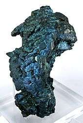
The Flambeau Copper Mine was operated by Kennecott from 1993 to 1997. This was a very rich volcanogenic massive sulfide ore deposit, so rich that the ore was shipped directly to the smelter. Flambeau has since been permanently closed and the site reclaimed.[9]
2002 tornado
On September 2, 2002, a tornado rated at F3 strength destroyed much of Ladysmith's downtown area. Overall damage was estimated at $20 million (USD), but there were no fatalities.[10]
Geography
Ladysmith is located at 45°27′50″N 91°6′0″W / 45.46389°N 91.10000°W. According to the United States Census Bureau, the city has a total area of 4.59 square miles (11.89 km2), of which 4.21 square miles (10.90 km2) is land and 0.38 square miles (0.98 km2) is water.[1]
Demographics
| Historical population | |||
|---|---|---|---|
| Census | Pop. | %± | |
| 1910 | 2,352 | — | |
| 1920 | 3,581 | 52.3% | |
| 1930 | 3,493 | −2.5% | |
| 1940 | 3,671 | 5.1% | |
| 1950 | 3,924 | 6.9% | |
| 1960 | 3,584 | −8.7% | |
| 1970 | 3,674 | 2.5% | |
| 1980 | 3,826 | 4.1% | |
| 1990 | 3,938 | 2.9% | |
| 2000 | 3,932 | −0.2% | |
| 2010 | 3,414 | −13.2% | |
| Est. 2015 | 3,188 | [11] | −6.6% |
2010 census
As of the census[3] of 2010, there were 3,414 people, 1,527 households, and 806 families residing in the city. The population density was 810.9 inhabitants per square mile (313.1/km2). There were 1,667 housing units at an average density of 396.0 per square mile (152.9/km2). The racial makeup of the city was 96.3% White, 0.6% African American, 0.8% Native American, 0.6% Asian, 0.5% from other races, and 1.2% from two or more races. Hispanic or Latino of any race were 1.6% of the population.
There were 1,527 households of which 26.1% had children under the age of 18 living with them, 37.1% were married couples living together, 10.7% had a female householder with no husband present, 5.0% had a male householder with no wife present, and 47.2% were non-families. 41.7% of all households were made up of individuals and 20.2% had someone living alone who was 65 years of age or older. The average household size was 2.14 and the average family size was 2.86.
The median age in the city was 43.8 years. 22.3% of residents were under the age of 18; 7% were between the ages of 18 and 24; 21.9% were from 25 to 44; 25.7% were from 45 to 64; and 23% were 65 years of age or older. The gender makeup of the city was 45.6% male and 54.4% female.
2000 census
As of the census[5] of 2000, there were 3,932 people, 1,570 households, and 916 families residing in the city. The population density was 1,008.9 people per square mile (389.3/km²). There were 1,660 housing units at an average density of 425.9 per square mile (164.3/km²). The racial makeup of the city was 96.31% White, 1.48% African American, 0.56% Native American, 0.48% Asian, 0.13% Pacific Islander, 0.10% from other races, and 0.94% from two or more races. Hispanic or Latino of any race were 0.76% of the population.
There were 1,570 households out of which 28.2% had children under the age of 18 living with them, 43.4% were married couples living together, 11.0% had a female householder with no husband present, and 41.6% were non-families. 35.8% of all households were made up of individuals and 19.2% had someone living alone who was 65 years of age or older. The average household size was 2.25 and the average family size was 2.92.
In the city the population was spread out with 22.8% under the age of 18, 13.4% from 18 to 24, 23.7% from 25 to 44, 18.7% from 45 to 64, and 21.4% who were 65 years of age or older. The median age was 37 years. For every 100 females there were 87.4 males. For every 100 females age 18 and over, there were 83.3 males.
The median income for a household in the city was $28,274, and the median income for a family was $40,526. Males had a median income of $26,725 versus $20,826 for females. The per capita income for the city was $15,499. About 7.2% of families and 12.2% of the population were below the poverty line, including 11.1% of those under age 18 and 11.0% of those age 65 or over.
Transportation
Rusk County Airport (KRCX) serves Ladysmith.
The Rusk County Transit Commission provides transportation within Rusk County.
Education
Ladysmith is served by the Ladysmith School District, which administers Ladysmith High School and Ladysmith Elementary School. Ladysmith is also home to private schools Our Lady of Sorrows, a Catholic grade school, and North Cedar Academy, a high school.
Ladysmith was the home of Mount Senario College, which closed in 2002. In the 2006-2007 school year, part of the former campus was operated as Concordia Preparatory School, a private Christian high school. That institution also faced financial problems and closed. Silver Lake College of Manitowoc, Wisconsin began offering courses at Mount Senario, renamed "Mount Senario Education Center", beginning September, 2009.[13]
Notable people
- Gary Beecham, artist
- Lois Capps, member of the United States House of Representatives from California
- Jorge A. Carow, Wisconsin State Assembly
- Donald J. Hoffman, Air Force 4-star general
- Ron Kovic, author, Vietnam War veteran
- Jim Leonhard, NFL player
- Earl Maves, NFL player
- Martin Reynolds, mayor of Ladysmith, Wisconsin State Assembly
References
- 1 2 "US Gazetteer files 2010". United States Census Bureau. Retrieved 2012-11-18.
- ↑ "US Board on Geographic Names". United States Geological Survey. 2007-10-25. Retrieved 2008-01-31.
- 1 2 "American FactFinder". United States Census Bureau. Retrieved 2012-11-18.
- ↑ "Population Estimates". United States Census Bureau. Retrieved 2013-06-24.
- 1 2 "American FactFinder". United States Census Bureau. Retrieved 2008-01-31.
- ↑ "Ladysmith". Geographic Names Information System. United States Geological Survey. Retrieved 2009-02-04.
- ↑ Rusk County Historical Society, ed. (1983). History of Rusk County, Wisconsin. Dallas, Texas: Taylor Publishing Company. p. 38. Retrieved 2015-08-19.
- ↑ Adams, Peter James (1979-04-08). "Charles R. Smith House" (PDF). NRHP Inventory-Nomination Form. US Dept. of the Interior. National Park Service. Retrieved 2015-08-08.
- ↑ Flambeau Mine at Mindat.org
- ↑ USA Today
- ↑ "Annual Estimates of the Resident Population for Incorporated Places: April 1, 2010 to July 1, 2015". Retrieved July 2, 2016.
- ↑ "Census of Population and Housing". Census.gov. Retrieved June 4, 2015.
- ↑ Silver Lake College: Mount Senario Education Center's website
External links
- City of Ladysmith
- Ladysmith Chamber of Commerce
- Ladysmith, Wisconsin is at coordinates 45°27′50″N 91°6′0″W / 45.46389°N 91.10000°W.
- Sanborn fire insurance maps: 1902 1909 1914
Municipalities and communities of Rusk County, Wisconsin, United States | ||
|---|---|---|
| City | 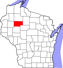 | |
| Villages | ||
| Towns | ||
| Unincorporated communities | ||