Tornado
| Tornado | |
|---|---|
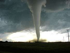 A tornado approaching Elie, Manitoba. | |
| Sign | A large spinning/twirling funnel. |
| Type | Extreme |
| Cloud of origin | Cumulonimbus, Funnel or Wall. |
| Effect | Death, injury, and damage. |
| Part of the nature series |
| Weather |
|---|
| Calendar seasons |
| Tropical seasons |
| Storms |
| Precipitation |
| Topics |
|
|
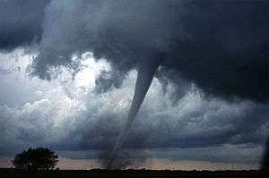
A tornado is a violently rotating column of air that spins while in contact with both the surface of the Earth and a cumulonimbus cloud or, in rare cases, the base of a cumulus cloud. They are often referred to as twisters, whirlwinds or cyclones,[1] although the word cyclone is used in meteorology to name any closed low pressure circulation. Tornadoes come in many shapes and sizes, but they are typically in the form of a visible condensation funnel originating from the base of a huge storm cloud, whose narrow end touches the earth and is often encircled by a basal cloud of debris and dust. Most tornadoes have wind speeds less than 110 miles per hour (180 km/h), are about 250 feet (80 m) across, and travel a few miles (several kilometers) before dissipating. The most extreme tornadoes can attain wind speeds of more than 300 miles per hour (480 km/h), are more than two miles (3 km) in diameter, and stay on the ground for dozens of miles (more than 100 km).[2][3][4]
Various types of tornadoes include the multiple vortex tornado, landspout and waterspout. Waterspouts are characterized by a spiraling funnel-shaped wind current, connecting to a large cumulus or cumulonimbus cloud. They are generally classified as non-supercellular tornadoes that develop over bodies of water, but there is disagreement over whether to classify them as true tornadoes. These spiraling columns of air frequently develop in tropical areas close to the equator, and are less common at high latitudes.[5] Other tornado-like phenomena that exist in nature include the gustnado, dust devil, fire whirls, and steam devil. Downbursts are frequently confused with tornadoes, though their action is dissimilar.
Tornadoes have been observed and documented on every continent except Antarctica. However, the vast majority of tornadoes occur in the Tornado Alley region of the United States, although they can occur nearly anywhere in North America.[6] They also occasionally occur in south-central and eastern Asia, northern and east-central South America, Southern Africa, northwestern and southeast Europe, western and southeastern Australia, and New Zealand.[7] Tornadoes can be detected before or as they occur through the use of Pulse-Doppler radar by recognizing patterns in velocity and reflectivity data, such as hook echoes or debris balls, as well as through the efforts of storm spotters.
There are several scales for rating the strength of tornadoes. The Fujita scale rates tornadoes by damage caused and has been replaced in some countries by the updated Enhanced Fujita Scale. An F0 or EF0 tornado, the weakest category, damages trees, but not substantial structures. An F5 or EF5 tornado, the strongest category, rips buildings off their foundations and can deform large skyscrapers. The similar TORRO scale ranges from a T0 for extremely weak tornadoes to T11 for the most powerful known tornadoes.[8] Doppler radar data, photogrammetry, and ground swirl patterns (cycloidal marks) may also be analyzed to determine intensity and assign a rating.[9][10]

Etymology
The word tornado is an altered form of the Spanish word tronada, which means "thunderstorm". This in turn was taken from the Latin tonare, meaning "to thunder". It most likely reached its present form through a combination of the Spanish tronada and tornar ("to turn"); however, this may be a folk etymology.[11][12] A tornado is also commonly referred to as a "twister", and is also sometimes referred to by the old-fashioned colloquial term cyclone.[13][14] The term "cyclone" is used as a synonym for "tornado" in the often-aired 1939 film The Wizard of Oz. The term "twister" is also used in that film, along with being the title of the 1996 tornado-related film Twister.
Definitions
A tornado is "a violently rotating column of air, in contact with the ground, either pendant from a cumuliform cloud or underneath a cumuliform cloud, and often (but not always) visible as a funnel cloud".[15] For a vortex to be classified as a tornado, it must be in contact with both the ground and the cloud base. Scientists have not yet created a complete definition of the word; for example, there is disagreement as to whether separate touchdowns of the same funnel constitute separate tornadoes.[4] Tornado refers to the vortex of wind, not the condensation cloud.[16][17]
Funnel cloud

A tornado is not necessarily visible; however, the intense low pressure caused by the high wind speeds (as described by Bernoulli's principle) and rapid rotation (due to cyclostrophic balance) usually causes water vapor in the air to condense into cloud droplets due to adiabatic cooling. This results in the formation of a visible funnel cloud or condensation funnel.[18]
There is some disagreement over the definition of funnel cloud and condensation funnel. According to the Glossary of Meteorology, a funnel cloud is any rotating cloud pendant from a cumulus or cumulonimbus, and thus most tornadoes are included under this definition.[19] Among many meteorologists, the funnel cloud term is strictly defined as a rotating cloud which is not associated with strong winds at the surface, and condensation funnel is a broad term for any rotating cloud below a cumuliform cloud.[4]
Tornadoes often begin as funnel clouds with no associated strong winds at the surface, and not all funnel clouds evolve into tornadoes. Most tornadoes produce strong winds at the surface while the visible funnel is still above the ground, so it is difficult to discern the difference between a funnel cloud and a tornado from a distance.[4]
Outbreaks and families
Occasionally, a single storm will produce more than one tornado, either simultaneously or in succession. Multiple tornadoes produced by the same storm cell are referred to as a "tornado family".[20] Several tornadoes are sometimes spawned from the same large-scale storm system. If there is no break in activity, this is considered a tornado outbreak (although the term "tornado outbreak" has various definitions). A period of several successive days with tornado outbreaks in the same general area (spawned by multiple weather systems) is a tornado outbreak sequence, occasionally called an extended tornado outbreak.[15][21][22]
Characteristics
Size and shape

Most tornadoes take on the appearance of a narrow funnel, a few hundred yards (meters) across, with a small cloud of debris near the ground. Tornadoes may be obscured completely by rain or dust. These tornadoes are especially dangerous, as even experienced meteorologists might not see them.[23] Tornadoes can appear in many shapes and sizes.
Small, relatively weak landspouts may be visible only as a small swirl of dust on the ground. Although the condensation funnel may not extend all the way to the ground, if associated surface winds are greater than 40 mph (64 km/h), the circulation is considered a tornado.[16] A tornado with a nearly cylindrical profile and relative low height is sometimes referred to as a "stovepipe" tornado. Large single-vortex tornadoes can look like large wedges stuck into the ground, and so are known as "wedge tornadoes" or "wedges". The "stovepipe" classification is also used for this type of tornado, if it otherwise fits that profile. A wedge can be so wide that it appears to be a block of dark clouds, wider than the distance from the cloud base to the ground. Even experienced storm observers may not be able to tell the difference between a low-hanging cloud and a wedge tornado from a distance. Many, but not all major tornadoes are wedges.[24]
Tornadoes in the dissipating stage can resemble narrow tubes or ropes, and often curl or twist into complex shapes. These tornadoes are said to be "roping out", or becoming a "rope tornado". When they rope out, the length of their funnel increases, which forces the winds within the funnel to weaken due to conservation of angular momentum.[25] Multiple-vortex tornadoes can appear as a family of swirls circling a common center, or they may be completely obscured by condensation, dust, and debris, appearing to be a single funnel.[26]
In the United States, tornadoes are around 500 feet (150 m) across on average and travel on the ground for 5 miles (8.0 km).[23] However, there is a wide range of tornado sizes. Weak tornadoes, or strong yet dissipating tornadoes, can be exceedingly narrow, sometimes only a few feet or couple meters across. One tornado was reported to have a damage path only 7 feet (2 m) long.[23] On the other end of the spectrum, wedge tornadoes can have a damage path a mile (1.6 km) wide or more. A tornado that affected Hallam, Nebraska on May 22, 2004, was up to 2.5 miles (4.0 km) wide at the ground, and a tornado in El Reno, Oklahoma on May 31, 2013 was approximately 2.6 miles (4.2 km) wide, the widest on record.[3][27]
In terms of path length, the Tri-State Tornado, which affected parts of Missouri, Illinois, and Indiana on March 18, 1925, was on the ground continuously for 219 miles (352 km). Many tornadoes which appear to have path lengths of 100 miles (160 km) or longer are composed of a family of tornadoes which have formed in quick succession; however, there is no substantial evidence that this occurred in the case of the Tri-State Tornado.[21] In fact, modern reanalysis of the path suggests that the tornado may have begun 15 miles (24 km) further west than previously thought.[28]
Appearance
Tornadoes can have a wide range of colors, depending on the environment in which they form. Those that form in dry environments can be nearly invisible, marked only by swirling debris at the base of the funnel. Condensation funnels that pick up little or no debris can be gray to white. While traveling over a body of water (as a waterspout), tornadoes can turn very white or even blue. Slow-moving funnels, which ingest a considerable amount of debris and dirt, are usually darker, taking on the color of debris. Tornadoes in the Great Plains can turn red because of the reddish tint of the soil, and tornadoes in mountainous areas can travel over snow-covered ground, turning white.[23]

Lighting conditions are a major factor in the appearance of a tornado. A tornado which is "back-lit" (viewed with the sun behind it) appears very dark. The same tornado, viewed with the sun at the observer's back, may appear gray or brilliant white. Tornadoes which occur near the time of sunset can be many different colors, appearing in hues of yellow, orange, and pink.[13][30]
Dust kicked up by the winds of the parent thunderstorm, heavy rain and hail, and the darkness of night are all factors which can reduce the visibility of tornadoes. Tornadoes occurring in these conditions are especially dangerous, since only weather radar observations, or possibly the sound of an approaching tornado, serve as any warning to those in the storm's path. Most significant tornadoes form under the storm's updraft base, which is rain-free,[31] making them visible.[32] Also, most tornadoes occur in the late afternoon, when the bright sun can penetrate even the thickest clouds.[21] Night-time tornadoes are often illuminated by frequent lightning.
There is mounting evidence, including Doppler On Wheels mobile radar images and eyewitness accounts, that most tornadoes have a clear, calm center with extremely low pressure, akin to the eye of tropical cyclones. Lightning is said to be the source of illumination for those who claim to have seen the interior of a tornado.[33][34][35]
Rotation
Tornadoes normally rotate cyclonically (when viewed from above, this is counterclockwise in the northern hemisphere and clockwise in the southern). While large-scale storms always rotate cyclonically due to the Coriolis effect, thunderstorms and tornadoes are so small that the direct influence of the Coriolis effect is unimportant, as indicated by their large Rossby numbers. Supercells and tornadoes rotate cyclonically in numerical simulations even when the Coriolis effect is neglected.[36][37] Low-level mesocyclones and tornadoes owe their rotation to complex processes within the supercell and ambient environment.[38]
Approximately 1 percent of tornadoes rotate in an anticyclonic direction in the northern hemisphere. Typically, systems as weak as landspouts and gustnadoes can rotate anticyclonically, and usually only those which form on the anticyclonic shear side of the descending rear flank downdraft (RFD) in a cyclonic supercell.[39] On rare occasions, anticyclonic tornadoes form in association with the mesoanticyclone of an anticyclonic supercell, in the same manner as the typical cyclonic tornado, or as a companion tornado either as a satellite tornado or associated with anticyclonic eddies within a supercell.[40]
Sound and seismology

Tornadoes emit widely on the acoustics spectrum and the sounds are caused by multiple mechanisms. Various sounds of tornadoes have been reported, mostly related to familiar sounds for the witness and generally some variation of a whooshing roar. Popularly reported sounds include a freight train, rushing rapids or waterfall, a nearby jet engine, or combinations of these. Many tornadoes are not audible from much distance; the nature and propagation distance of the audible sound depends on atmospheric conditions and topography.
The winds of the tornado vortex and of constituent turbulent eddies, as well as airflow interaction with the surface and debris, contribute to the sounds. Funnel clouds also produce sounds. Funnel clouds and small tornadoes are reported as whistling, whining, humming, or the buzzing of innumerable bees or electricity, or more or less harmonic, whereas many tornadoes are reported as a continuous, deep rumbling, or an irregular sound of "noise".[41]
Since many tornadoes are audible only when very near, sound is not reliable warning of a tornado. Tornadoes are also not the only source of such sounds in severe thunderstorms; any strong, damaging wind, a severe hail volley, or continuous thunder in a thunderstorm may produce a roaring sound.[42]
Tornadoes also produce identifiable inaudible infrasonic signatures.[43]
Unlike audible signatures, tornadic signatures have been isolated; due to the long distance propagation of low-frequency sound, efforts are ongoing to develop tornado prediction and detection devices with additional value in understanding tornado morphology, dynamics, and creation.[44] Tornadoes also produce a detectable seismic signature, and research continues on isolating it and understanding the process.[45]
Electromagnetic, lightning, and other effects
Tornadoes emit on the electromagnetic spectrum, with sferics and E-field effects detected.[44][46][47] There are observed correlations between tornadoes and patterns of lightning. Tornadic storms do not contain more lightning than other storms and some tornadic cells never produce lightning at all. More often than not, overall cloud-to-ground (CG) lightning activity decreases as a tornado touches the surface and returns to the baseline level when the tornado dissipates. In many cases, intense tornadoes and thunderstorms exhibit an increased and anomalous dominance of positive polarity CG discharges.[48] Electromagnetics and lightning have little or nothing to do directly with what drives tornadoes (tornadoes are basically a thermodynamic phenomenon), although there are likely connections with the storm and environment affecting both phenomena.
Luminosity has been reported in the past and is probably due to misidentification of external light sources such as lightning, city lights, and power flashes from broken lines, as internal sources are now uncommonly reported and are not known to ever have been recorded. In addition to winds, tornadoes also exhibit changes in atmospheric variables such as temperature, moisture, and pressure. For example, on June 24, 2003 near Manchester, South Dakota, a probe measured a 100 mbar (hPa) (2.95 inHg) pressure decrease. The pressure dropped gradually as the vortex approached then dropped extremely rapidly to 850 mbar (hPa) (25.10 inHg) in the core of the violent tornado before rising rapidly as the vortex moved away, resulting in a V-shape pressure trace. Temperature tends to decrease and moisture content to increase in the immediate vicinity of a tornado.[49]
Life cycle

Supercell relationship
Tornadoes often develop from a class of thunderstorms known as supercells. Supercells contain mesocyclones, an area of organized rotation a few miles up in the atmosphere, usually 1–6 miles (2–10 km) across. Most intense tornadoes (EF3 to EF5 on the Enhanced Fujita Scale) develop from supercells. In addition to tornadoes, very heavy rain, frequent lightning, strong wind gusts, and hail are common in such storms.
Most tornadoes from supercells follow a recognizable life cycle. That begins when increasing rainfall drags with it an area of quickly descending air known as the rear flank downdraft (RFD). This downdraft accelerates as it approaches the ground, and drags the supercell's rotating mesocyclone towards the ground with it.[16]
Formation
As the mesocyclone lowers below the cloud base, it begins to take in cool, moist air from the downdraft region of the storm. The convergence of warm air in the updraft and cool air causes a rotating wall cloud to form. The RFD also focuses the mesocyclone's base, causing it to draw air from a smaller and smaller area on the ground. As the updraft intensifies, it creates an area of low pressure at the surface. This pulls the focused mesocyclone down, in the form of a visible condensation funnel. As the funnel descends, the RFD also reaches the ground, fanning outward and creating a gust front that can cause severe damage a considerable distance from the tornado. Usually, the funnel cloud begins causing damage on the ground (becoming a tornado) within a few minutes of the RFD reaching the ground.[16][50]
Maturity
Initially, the tornado has a good source of warm, moist air flowing inward to power it, and it grows until it reaches the "mature stage". This can last anywhere from a few minutes to more than an hour, and during that time a tornado often causes the most damage, and in rare cases can be more than one mile (1.6 km) across. The low pressured atmosphere at the base of the tornado is essential to the endurance of the system.[51] Meanwhile, the RFD, now an area of cool surface winds, begins to wrap around the tornado, cutting off the inflow of warm air which previously fed the tornado.[16]
Dissipation
As the RFD completely wraps around and chokes off the tornado's air supply, the vortex begins to weaken, and become thin and rope-like. This is the "dissipating stage", often lasting no more than a few minutes, after which the tornado ends. During this stage the shape of the tornado becomes highly influenced by the winds of the parent storm, and can be blown into fantastic patterns.[21][29][30] Even though the tornado is dissipating, it is still capable of causing damage. The storm is contracting into a rope-like tube and, due to conservation of angular momentum, winds can increase at this point.[25]
As the tornado enters the dissipating stage, its associated mesocyclone often weakens as well, as the rear flank downdraft cuts off the inflow powering it. Sometimes, in intense supercells, tornadoes can develop cyclically. As the first mesocyclone and associated tornado dissipate, the storm's inflow may be concentrated into a new area closer to the center of the storm and possibly feed a new mesocyclone. If a new mesocyclone develops, the cycle may start again, producing one or more new tornadoes. Occasionally, the old (occluded) mesocyclone and the new mesocyclone produce a tornado at the same time.
Although this is a widely accepted theory for how most tornadoes form, live, and die, it does not explain the formation of smaller tornadoes, such as landspouts, long-lived tornadoes, or tornadoes with multiple vortices. These each have different mechanisms which influence their development—however, most tornadoes follow a pattern similar to this one.[52]
Types
Multiple vortex
A multiple-vortex tornado is a type of tornado in which two or more columns of spinning air rotate about their own axis and at the same time around a common center. A multi-vortex structure can occur in almost any circulation, but is very often observed in intense tornadoes. These vortices often create small areas of heavier damage along the main tornado path.[4][16] This is a phenomenon that is distinct from a satellite tornado, which is a smaller tornado which forms very near a large, strong tornado contained within the same mesocyclone. The satellite tornado may appear to "orbit" the larger tornado (hence the name), giving the appearance of one, large multi-vortex tornado. However, a satellite tornado is a distinct circulation, and is much smaller than the main funnel.[4]
Waterspout

A waterspout is defined by the National Weather Service as a tornado over water. However, researchers typically distinguish "fair weather" waterspouts from tornadic waterspouts. Fair weather waterspouts are less severe but far more common, and are similar to dust devils and landspouts. They form at the bases of cumulus congestus clouds over tropical and subtropical waters. They have relatively weak winds, smooth laminar walls, and typically travel very slowly. They occur most commonly in the Florida Keys and in the northern Adriatic Sea.[53][54][55] In contrast, tornadic waterspouts are stronger tornadoes over water. They form over water similarly to mesocyclonic tornadoes, or are stronger tornadoes which cross over water. Since they form from severe thunderstorms and can be far more intense, faster, and longer-lived than fair weather waterspouts, they are more dangerous.[56] In official tornado statistics, waterspouts are generally not counted unless they affect land, though some European weather agencies count waterspouts and tornadoes together.[4][57]
Landspout
A landspout, or dust-tube tornado, is a tornado not associated with a mesocyclone. The name stems from their characterization as a "fair weather waterspout on land". Waterspouts and landspouts share many defining characteristics, including relative weakness, short lifespan, and a small, smooth condensation funnel which often does not reach the surface. Landspouts also create a distinctively laminar cloud of dust when they make contact with the ground, due to their differing mechanics from true mesoform tornadoes. Though usually weaker than classic tornadoes, they can produce strong winds which could cause serious damage.[4][16]
Similar circulations
Gustnado

A gustnado, or gust front tornado, is a small, vertical swirl associated with a gust front or downburst. Because they are not connected with a cloud base, there is some debate as to whether or not gustnadoes are tornadoes. They are formed when fast moving cold, dry outflow air from a thunderstorm is blown through a mass of stationary, warm, moist air near the outflow boundary, resulting in a "rolling" effect (often exemplified through a roll cloud). If low level wind shear is strong enough, the rotation can be turned vertically or diagonally and make contact with the ground. The result is a gustnado.[4][58] They usually cause small areas of heavier rotational wind damage among areas of straight-line wind damage.
Dust devil
A dust devil (also known as a whirlwind) resembles a tornado in that it is a vertical swirling column of air. However, they form under clear skies and are no stronger than the weakest tornadoes. They form when a strong convective updraft is formed near the ground on a hot day. If there is enough low level wind shear, the column of hot, rising air can develop a small cyclonic motion that can be seen near the ground. They are not considered tornadoes because they form during fair weather and are not associated with any clouds. However, they can, on occasion, result in major damage.[23][59]
Fire whirls
Small-scale, tornado-like circulations can occur near any intense surface heat source. Those that occur near intense wildfires are called fire whirls. They are not considered tornadoes, except in the rare case where they connect to a pyrocumulus or other cumuliform cloud above. Fire whirls usually are not as strong as tornadoes associated with thunderstorms. They can, however, produce significant damage.[21]
Steam devils
A steam devil is a rotating updraft between 50 and 200 meters wide that involves steam or smoke. These formations do not involve high wind speeds, only completing a few rotations per minute. Steam devils are very rare. They most often form from smoke issuing from a power plant's smokestack. Hot springs and deserts may also be suitable locations for a tighter, faster-rotating steam devil to form. The phenomenon can occur over water, when cold arctic air passes over relatively warm water.[23]
Intensity and damage
| F0 EF0 |
F1 EF1 |
F2 EF2 |
F3 EF3 |
F4 EF4 |
F5 EF5 |
|---|---|---|---|---|---|
| Weak | Strong | Violent | |||
| Significant | |||||
| Intense | |||||
The Fujita scale and the Enhanced Fujita Scale rate tornadoes by damage caused. The Enhanced Fujita (EF) Scale was an update to the older Fujita scale, by expert elicitation, using engineered wind estimates and better damage descriptions. The EF Scale was designed so that a tornado rated on the Fujita scale would receive the same numerical rating, and was implemented starting in the United States in 2007. An EF0 tornado will probably damage trees but not substantial structures, whereas an EF5 tornado can rip buildings off their foundations leaving them bare and even deform large skyscrapers. The similar TORRO scale ranges from a T0 for extremely weak tornadoes to T11 for the most powerful known tornadoes. Doppler weather radar data, photogrammetry, and ground swirl patterns (cycloidal marks) may also be analyzed to determine intensity and award a rating.[4][61][62]

Tornadoes vary in intensity regardless of shape, size, and location, though strong tornadoes are typically larger than weak tornadoes. The association with track length and duration also varies, although longer track tornadoes tend to be stronger.[63] In the case of violent tornadoes, only a small portion of the path is of violent intensity, most of the higher intensity from subvortices.[21]
In the United States, 80% of tornadoes are EF0 and EF1 (T0 through T3) tornadoes. The rate of occurrence drops off quickly with increasing strength—less than 1% are violent tornadoes (EF4, T8 or stronger).[64] Outside Tornado Alley, and North America in general, violent tornadoes are extremely rare. This is apparently mostly due to the lesser number of tornadoes overall, as research shows that tornado intensity distributions are fairly similar worldwide. A few significant tornadoes occur annually in Europe, Asia, southern Africa, and southeastern South America, respectively.[65]
Climatology

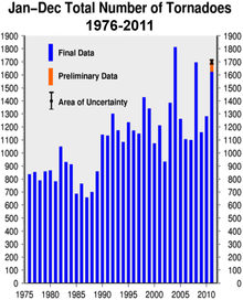
The United States has the most tornadoes of any country, nearly four times more than estimated in all of Europe, excluding waterspouts.[66] This is mostly due to the unique geography of the continent. North America is a large continent that extends from the tropics north into arctic areas, and has no major east-west mountain range to block air flow between these two areas. In the middle latitudes, where most tornadoes of the world occur, the Rocky Mountains block moisture and buckle the atmospheric flow, forcing drier air at mid-levels of the troposphere due to downsloped winds, and causing the formation of a low pressure area downwind to the east of the mountains. Increased westerly flow off the Rockies force the formation of a dry line when the flow aloft is strong,[67] while the Gulf of Mexico fuels abundant low-level moisture in the southerly flow to its east. This unique topography allows for frequent collisions of warm and cold air, the conditions that breed strong, long-lived storms throughout the year. A large portion of these tornadoes form in an area of the central United States known as Tornado Alley.[6] This area extends into Canada, particularly Ontario and the Prairie Provinces, although southeast Quebec, the interior of British Columbia, and western New Brunswick are also tornado-prone.[68] Tornadoes also occur across northeastern Mexico.[4]
The United States averages about 1,200 tornadoes per year, flowed by Canada, averaging 62 reported per year.[69] NOAA's has a higher average 100 per year in Canada.[70] The Netherlands has the highest average number of recorded tornadoes per area of any country (more than 20, or 0.0013 per sq mi (0.00048 per km2), annually), followed by the UK (around 33, or 0.00035 per sq mi (0.00013 per km2), per year), although those are of lower intensity, briefer[71][72] and cause minor damage.[66]

Tornadoes kill an average of 179 people per year in Bangladesh, the most in the world.[73] Reasons for this include the region's high population density, poor construction quality, and lack of tornado safety knowledge.[73][74] Other areas of the world that have frequent tornadoes include South Africa, the La Plata Basin area, portions of Europe, Australia and New Zealand, and far eastern Asia.[7][75]
Tornadoes are most common in spring and least common in winter, but tornadoes can occur any time of year that favorable conditions occur.[21] Spring and fall experience peaks of activity as those are the seasons when stronger winds, wind shear, and atmospheric instability are present.[76] Tornadoes are focused in the right front quadrant of landfalling tropical cyclones, which tend to occur in the late summer and autumn. Tornadoes can also be spawned as a result of eyewall mesovortices, which persist until landfall.[77]
Tornado occurrence is highly dependent on the time of day, because of solar heating.[78] Worldwide, most tornadoes occur in the late afternoon, between 3 pm and 7 pm local time, with a peak near 5 pm.[79][80][81][82][83] Destructive tornadoes can occur at any time of day. The Gainesville Tornado of 1936, one of the deadliest tornadoes in history, occurred at 8:30 am local time.[21]
Associations with climate and climate change
Associations with various climate and environmental trends exist. For example, an increase in the sea surface temperature of a source region (e.g. Gulf of Mexico and Mediterranean Sea) increases atmospheric moisture content. Increased moisture can fuel an increase in severe weather and tornado activity, particularly in the cool season.[84]
Some evidence does suggest that the Southern Oscillation is weakly correlated with changes in tornado activity, which vary by season and region, as well as whether the ENSO phase is that of El Niño or La Niña.[85] Research has found that fewer tornadoes and hailstorms occur in winter and spring in the U.S. central and southern plains during El Niño, and more occur during La Niña, than in years when temperatures in the Pacific are relatively stable. Ocean conditions could be used to forecast extreme spring storm events several months in advance.[86]
Climatic shifts may affect tornadoes via teleconnections in shifting the jet stream and the larger weather patterns. The climate-tornado link is confounded by the forces affecting larger patterns and by the local, nuanced nature of tornadoes. Although it is reasonable to suspect that global warming may affect trends in tornado activity,[87] any such effect is not yet identifiable due to the complexity, local nature of the storms, and database quality issues. Any effect would vary by region.[88]
Detection
Rigorous attempts to warn of tornadoes began in the United States in the mid-20th century. Before the 1950s, the only method of detecting a tornado was by someone seeing it on the ground. Often, news of a tornado would reach a local weather office after the storm. However, with the advent of weather radar, areas near a local office could get advance warning of severe weather. The first public tornado warnings were issued in 1950 and the first tornado watches and convective outlooks in 1952. In 1953 it was confirmed that hook echoes are associated with tornadoes.[89] By recognizing these radar signatures, meteorologists could detect thunderstorms probably producing tornadoes from dozens of miles away.[90]
Radar
Today, most developed countries have a network of weather radars, which remains the main method of detecting signatures probably associated with tornadoes. In the United States and a few other countries, Doppler weather radar stations are used. These devices measure the velocity and radial direction (towards or away from the radar) of the winds in a storm, and so can spot evidence of rotation in storms from more than a hundred miles (160 km) away. When storms are distant from a radar, only areas high within the storm are observed and the important areas below are not sampled.[91] Data resolution also decreases with distance from the radar. Some meteorological situations leading to tornadogenesis are not readily detectable by radar and on occasion tornado development may occur more quickly than radar can complete a scan and send the batch of data. Doppler radar systems can detect mesocyclones within the supercell of a thunderstorm. This allows meteorologists to predict tornado formations throughout thunderstorms.[92] Also, most populated areas on Earth are now visible from the Geostationary Operational Environmental Satellites (GOES), which aid in the nowcasting of tornadic storms.[93]
Storm spotting
In the mid-1970s, the U.S. National Weather Service (NWS) increased its efforts to train storm spotters to spot key features of storms which indicate severe hail, damaging winds, and tornadoes, as well as damage itself and flash flooding. The program was called Skywarn, and the spotters were local sheriff's deputies, state troopers, firefighters, ambulance drivers, amateur radio operators, civil defense (now emergency management) spotters, storm chasers, and ordinary citizens. When severe weather is anticipated, local weather service offices request that these spotters look out for severe weather, and report any tornadoes immediately, so that the office can warn of the hazard.
Usually spotters are trained by the NWS on behalf of their respective organizations, and report to them. The organizations activate public warning systems such as sirens and the Emergency Alert System (EAS), and forward the report to the NWS.[94] There are more than 230,000 trained Skywarn weather spotters across the United States.[95]
In Canada, a similar network of volunteer weather watchers, called Canwarn, helps spot severe weather, with more than 1,000 volunteers.[93] In Europe, several nations are organizing spotter networks under the auspices of Skywarn Europe[96] and the Tornado and Storm Research Organisation (TORRO) has maintained a network of spotters in the United Kingdom since 1974.[97]
Storm spotters are needed because radar systems such as NEXRAD do not detect a tornado; merely signatures which hint at the presence of tornadoes.[98] Radar may give a warning before there is any visual evidence of a tornado or imminent tornado, but ground truth from an observer can either verify the threat or determine that a tornado is not imminent.[99] The spotter's ability to see what radar cannot is especially important as distance from the radar site increases, because the radar beam becomes progressively higher in altitude further away from the radar, chiefly due to curvature of Earth, and the beam also spreads out.[91]
Visual evidence

Storm spotters are trained to discern whether a storm seen from a distance is a supercell. They typically look to its rear, the main region of updraft and inflow. Under the updraft is a rain-free base, and the next step of tornadogenesis is the formation of a rotating wall cloud. The vast majority of intense tornadoes occur with a wall cloud on the backside of a supercell.[64]
Evidence of a supercell comes from the storm's shape and structure, and cloud tower features such as a hard and vigorous updraft tower, a persistent, large overshooting top, a hard anvil (especially when backsheared against strong upper level winds), and a corkscrew look or striations. Under the storm and closer to where most tornadoes are found, evidence of a supercell and likelihood of a tornado includes inflow bands (particularly when curved) such as a "beaver tail", and other clues such as strength of inflow, warmth and moistness of inflow air, how outflow- or inflow-dominant a storm appears, and how far is the front flank precipitation core from the wall cloud. Tornadogenesis is most likely at the interface of the updraft and rear flank downdraft, and requires a balance between the outflow and inflow.[16]
Only wall clouds that rotate spawn tornadoes, and usually precede the tornado by five to thirty minutes. Rotating wall clouds may be a visual manifestation of a low-level mesocyclone. Barring a low-level boundary, tornadogenesis is highly unlikely unless a rear flank downdraft occurs, which is usually visibly evidenced by evaporation of cloud adjacent to a corner of a wall cloud. A tornado often occurs as this happens or shortly after; first, a funnel cloud dips and in nearly all cases by the time it reaches halfway down, a surface swirl has already developed, signifying a tornado is on the ground before condensation connects the surface circulation to the storm. Tornadoes may also occur without wall clouds, under flanking lines, and on the leading edge. Spotters watch all areas of a storm, and the cloud base and surface.[100]
Extremes

The most record-breaking tornado in recorded history was the Tri-State Tornado, which roared through parts of Missouri, Illinois, and Indiana on March 18, 1925. It was likely an F5, though tornadoes were not ranked on any scale in that era. It holds records for longest path length (219 miles, 352 km), longest duration (about 3.5 hours), and fastest forward speed for a significant tornado (73 mph, 117 km/h) anywhere on Earth. In addition, it is the deadliest single tornado in United States history (695 dead).[21] The tornado was also the costliest tornado in history at the time (unadjusted for inflation), but in the years since has been surpassed by several others if population changes over time are not considered. When costs are normalized for wealth and inflation, it ranks third today.[101]
The deadliest tornado in world history was the Daultipur-Salturia Tornado in Bangladesh on April 26, 1989, which killed approximately 1,300 people.[73] Bangladesh has had at least 19 tornadoes in its history kill more than 100 people, almost half of the total in the rest of the world.
The most extensive tornado outbreak on record was the 2011 Super Outbreak, which spawned 362 confirmed tornadoes over the southeastern United States - 218 of them within a single 24-hour period. The previous record was the 1974 Super Outbreak which spawned 148 tornadoes.
While direct measurement of the most violent tornado wind speeds is nearly impossible, since conventional anemometers would be destroyed by the intense winds and flying debris, some tornadoes have been scanned by mobile Doppler radar units, which can provide a good estimate of the tornado's winds. The highest wind speed ever measured in a tornado, which is also the highest wind speed ever recorded on the planet, is 301 ± 20 mph (484 ± 32 km/h) in the F5 Bridge Creek-Moore, Oklahoma, tornado which killed 36 people.[102] Though the reading was taken about 100 feet (30 m) above the ground, this is a testament to the power of the strongest tornadoes.[2]
Storms that produce tornadoes can feature intense updrafts, sometimes exceeding 150 mph (240 km/h). Debris from a tornado can be lofted into the parent storm and carried a very long distance. A tornado which affected Great Bend, Kansas, in November 1915, was an extreme case, where a "rain of debris" occurred 80 miles (130 km) from the town, a sack of flour was found 110 miles (180 km) away, and a cancelled check from the Great Bend bank was found in a field outside of Palmyra, Nebraska, 305 miles (491 km) to the northeast.[103] Waterspouts and tornadoes have been advanced as an explanation for instances of raining fish and other animals.[104]
Safety
Though tornadoes can strike in an instant, there are precautions and preventative measures that people can take to increase the chances of surviving a tornado. Authorities such as the Storm Prediction Center advise having a pre-determined plan should a tornado warning be issued. When a warning is issued, going to a basement or an interior first-floor room of a sturdy building greatly increases chances of survival.[105] In tornado-prone areas, many buildings have storm cellars on the property. These underground refuges have saved thousands of lives.[106]
Some countries have meteorological agencies which distribute tornado forecasts and increase levels of alert of a possible tornado (such as tornado watches and warnings in the United States and Canada). Weather radios provide an alarm when a severe weather advisory is issued for the local area, though these are mainly available only in the United States. Unless the tornado is far away and highly visible, meteorologists advise that drivers park their vehicles far to the side of the road (so as not to block emergency traffic), and find a sturdy shelter. If no sturdy shelter is nearby, getting low in a ditch is the next best option. Highway overpasses are one of the worst places to take shelter during tornadoes, as the constricted space can be subject to increased wind speed and funneling of debris underneath the overpass.[107]
Myths and misconceptions
Folklore often identifies a green sky with tornadoes, and though the phenomenon may be associated with severe weather, there is no evidence linking it specifically with tornadoes.[108] It is often thought that opening windows will lessen the damage caused by the tornado. While there is a large drop in atmospheric pressure inside a strong tornado, it is unlikely that the pressure drop would be enough to cause the house to explode. Opening windows may actually increase the severity of the tornado's damage.[109] A violent tornado can destroy a house whether its windows are open or closed.[109][110]
Another commonly held misconception is that highway overpasses provide adequate shelter from tornadoes. This belief is partly inspired by widely circulated video captured during the 1991 tornado outbreak near Andover, Kansas, where a news crew and several other people take shelter under an overpass on the Kansas Turnpike and safely ride out a tornado as it passes by.[111] However, a highway overpass is a dangerous place during a tornado: the subjects of the video remained safe due to an unlikely combination of events: the storm in question was a weak tornado, did not directly strike the overpass, and the overpass itself was of a unique design.[111] Due to the Venturi effect, tornadic winds are accelerated in the confined space of an overpass.[112] Indeed, in the 1999 Oklahoma tornado outbreak of May 3, 1999, three highway overpasses were directly struck by tornadoes, and at all three locations there was a fatality, along with many life-threatening injuries.[113] By comparison, during the same tornado outbreak, more than 2000 homes were completely destroyed, with another 7000 damaged, and yet only a few dozen people died in their homes.[107]
An old belief is that the southwest corner of a basement provides the most protection during a tornado. The safest place is the side or corner of an underground room opposite the tornado's direction of approach (usually the northeast corner), or the central-most room on the lowest floor. Taking shelter in a basement, under a staircase, or under a sturdy piece of furniture such as a workbench further increases chances of survival.[109][110]
Finally, there are areas which people believe to be protected from tornadoes, whether by being in a city, near a major river, hill, or mountain, or even protected by supernatural forces.[114] Tornadoes have been known to cross major rivers, climb mountains,[115] affect valleys, and have damaged several city centers. As a general rule, no area is safe from tornadoes, though some areas are more susceptible than others.[23][109][110]
Ongoing research
Meteorology is a relatively young science and the study of tornadoes is newer still. Although researched for about 140 years and intensively for around 60 years, there are still aspects of tornadoes which remain a mystery.[116] Scientists have a fairly good understanding of the development of thunderstorms and mesocyclones,[117][118] and the meteorological conditions conducive to their formation. However, the step from supercell, or other respective formative processes, to tornadogenesis and the prediction of tornadic vs. non-tornadic mesocyclones is not yet well known and is the focus of much research.[76]
Also under study are the low-level mesocyclone and the stretching of low-level vorticity which tightens into a tornado,[76] in particular, what are the processes and what is the relationship of the environment and the convective storm. Intense tornadoes have been observed forming simultaneously with a mesocyclone aloft (rather than succeeding mesocyclogenesis) and some intense tornadoes have occurred without a mid-level mesocyclone.[119]
In particular, the role of downdrafts, particularly the rear-flank downdraft, and the role of baroclinic boundaries, are intense areas of study.[120]
Reliably predicting tornado intensity and longevity remains a problem, as do details affecting characteristics of a tornado during its life cycle and tornadolysis. Other rich areas of research are tornadoes associated with mesovortices within linear thunderstorm structures and within tropical cyclones.[121]
Scientists still do not know the exact mechanisms by which most tornadoes form, and occasional tornadoes still strike without a tornado warning being issued.[122] Analysis of observations including both stationary and mobile (surface and aerial) in-situ and remote sensing (passive and active) instruments generates new ideas and refines existing notions. Numerical modeling also provides new insights as observations and new discoveries are integrated into our physical understanding and then tested in computer simulations which validate new notions as well as produce entirely new theoretical findings, many of which are otherwise unattainable. Importantly, development of new observation technologies and installation of finer spatial and temporal resolution observation networks have aided increased understanding and better predictions.[123]
Research programs, including field projects such as the VORTEX projects (Verification of the Origins of Rotation in Tornadoes Experiment), deployment of TOTO (the TOtable Tornado Observatory), Doppler On Wheels (DOW), and dozens of other programs, hope to solve many questions that still plague meteorologists.[44] Universities, government agencies such as the National Severe Storms Laboratory, private-sector meteorologists, and the National Center for Atmospheric Research are some of the organizations very active in research; with various sources of funding, both private and public, a chief entity being the National Science Foundation.[98][124] The pace of research is partly constrained by the number of observations that can be taken; gaps in information about the wind, pressure, and moisture content throughout the local atmosphere; and the computing power available for simulation.[125]
Solar storms similar to tornadoes have been recorded, but it is unknown how closely related they are to their terrestrial counterparts.[126]
Gallery
- A tornado that occurred at Seymour, Texas in April 1979
 F4 Tornado in Roanoke, Illinois on July 13, 2004
.jpg) The mature stage of a tornado that occurred in Union City, Oklahoma on May 24, 1973
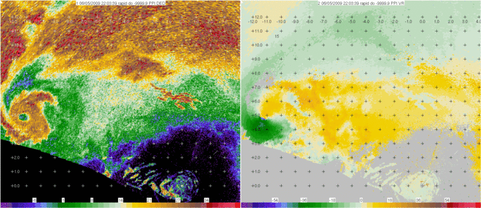
The mature stage of a tornado that occurred in Union City, Oklahoma on May 24, 1973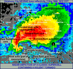 A radar image of a violently tornadic classic supercell near Oklahoma City, Oklahoma on May 3, 1999
- F5 Tornado approaching Elie, Manitoba on June 22, 2007
 A tornado south of Anadarko, Oklahoma on May 3, 1999 during the 1999 Oklahoma tornado outbreak
 A rare F0 Tornado in its final stages over the North Sea near Vrångö, Sweden on July 17, 2011
See also
References
- ↑ "merriam-webster.com". merriam-webster.com. Retrieved 2012-09-03.
- 1 2 Wurman, Joshua (2008-08-29). "Doppler On Wheels". Center for Severe Weather Research. Retrieved 2009-12-13.
- 1 2 "Hallam Nebraska Tornado". National Weather Service. National Oceanic and Atmospheric Administration. 2005-10-02. Retrieved 2009-11-15.
- 1 2 3 4 5 6 7 8 9 10 11 Roger Edwards (2006-04-04). "The Online Tornado FAQ". Storm Prediction Center. National Oceanic and Atmospheric Administration. Retrieved 2006-09-08.
- ↑ National Weather Service (2009-02-03). "15 January 2009: Lake Champlain Sea Smoke, Steam Devils, and Waterspout: Chapters IV and V". National Oceanic and Atmospheric Administration. Retrieved 2009-06-21.
- 1 2 Sid Perkins (2002-05-11). "Tornado Alley, USA". Science News. pp. 296–298. Archived from the original on 2006-08-25. Retrieved 2006-09-20.
- 1 2 "Tornado: Global occurrence". Encyclopædia Britannica Online. 2009. Retrieved 2009-12-13.
- ↑ Meaden, Terrance (2004). "Wind Scales: Beaufort, T — Scale, and Fujita's Scale". Tornado and Storm Research Organisation. Retrieved 2009-09-11.
- ↑ "Enhanced F Scale for Tornado Damage". Storm Prediction Center. National Oceanic and Atmospheric Administration. 2007-02-01. Retrieved 2009-06-21.
- ↑ Edwards, Roger et al. (May 2013). "Tornado Intensity Estimation: Past, Present, and Future." Bulletin of the American Meteorological Society. pp. 641-653. Retrieved 2013-12-18.
- ↑ Douglas Harper (2001). "Online Etymology Dictionary". Retrieved 2009-12-13.
- ↑ Frederick C Mish (1993). Merriam Webster's Collegiate Dictionary (10th ed.). Merriam-Webster, Incorporated. ISBN 0-87779-709-9. Retrieved 2009-12-13.
- 1 2 Tim Marshall (2008-11-09). "The Tornado Project's Terrific, Timeless and Sometimes Trivial Truths about Those Terrifying Twirling Twisters!". The Tornado Project. Retrieved 2008-11-09.
- ↑ "Frequently Asked Questions about Tornadoes". National Severe Storms Laboratory. 2009-07-20.
- 1 2 Glossary of Meteorology (2000). Section:T (2 ed.). American Meteorological Society. Retrieved 2009-11-15.
- 1 2 3 4 5 6 7 8 "Advanced Spotters' Field Guide" (PDF). National Oceanic and Atmospheric Administration. 2003-01-03. Retrieved 2009-12-13.
- ↑ Charles A Doswell III (2001-10-01). "What is a tornado?". Cooperative Institute for Mesoscale Meteorological Studies. Retrieved 2008-05-28.
- ↑ Nilton O. Renno (2008-07-03). "A thermodynamically general theory for convective vortices" (PDF). Tellus A. International Meteorological Institute in Stockholm. 60 (4): 688–99. Bibcode:2008TellA..60..688R. doi:10.1111/j.1600-0870.2008.00331.x. Retrieved 2009-12-12.
- ↑ Glossary of Meteorology (2000-06-30). Funnel cloud (2 ed.). American Meteorological Society. Retrieved 2009-02-25.
- ↑ Michael Branick (2006). "A Comprehensive Glossary of Weather Terms for Storm Spotters". National Oceanic and Atmospheric Administration. Archived from the original on 2003-08-03. Retrieved 2007-02-27.
- 1 2 3 4 5 6 7 8 9 10 Thomas P Grazulis (July 1993). Significant Tornadoes 1680–1991. St. Johnsbury, VT: The Tornado Project of Environmental Films. ISBN 1-879362-03-1.
- ↑ Russell S Schneider; Harold E. Brooks & Joseph T. Schaefer (2004). "Tornado Outbreak Day Sequences: Historic Events and Climatology (1875–2003)" (PDF). Retrieved 2007-03-20.
- 1 2 3 4 5 6 7 Walter A Lyons (1997). "Tornadoes". The Handy Weather Answer Book (2nd ed.). Detroit, Michigan: Visible Ink press. pp. 175–200. ISBN 0-7876-1034-8.
- ↑ Roger Edwards (2008-07-18). "Wedge Tornado". National Weather Service. National Oceanic and Atmospheric Administration. Retrieved 2007-02-28.
- 1 2 Singer, Oscar (May–July 1985). "27.0.0 General Laws Influencing the Creation of Bands of Strong Bands". Bible of Weather Forecasting. Singer Press. 1 (4): 57–58.
- ↑ Roger Edwards (2008-07-18). "Rope Tornado". National Weather Service. National Oceanic and Atmospheric Administration. Retrieved 2007-02-28.
- ↑ "May 31-June 1, 2013 Tornado and Flash Flood Event: The May 31, 2013 El Reno, OK Tornado". National Weather Service Weather Forecast Office – Norman, Oklahoma. Norman, Oklahoma: National Oceanic and Atmospheric Administration. July 28, 2014. Retrieved December 25, 2014.
- ↑ Charles A; III Doswell. "The Tri-State Tornado of 18 March 1925 Reanalysis Project" (Powerpoint Presentation). Retrieved 2007-04-07.
- 1 2 Roger Edwards (2009). "Public Domain Tornado Images". National Weather Service. National Oceanic and Atmospheric Administration. Retrieved 2009-11-17.
- 1 2 Linda Mercer Lloyd (1996). Target: Tornado (Videotape). The Weather Channel.
- ↑ "The Basics of Storm Spotting". National Weather Service. National Oceanic and Atmospheric Administration. 2009-01-15. Archived from the original on 2003-10-11. Retrieved 2009-11-17.
- ↑ Peterson, Franklynn; Kwsselman, Judi R (July 1978). "Tornado factory – giant simulator probes killer twisters". Popular Science. New York NY: Times Mirror Magazines. 213 (1): 76–78. ISSN 0161-7370.
- ↑ R. Monastersky (1999-05-15). "Oklahoma Tornado Sets Wind Record". Science News. pp. 308–309. Retrieved 2006-10-20.
- ↑ Alonzo A Justice (1930). "Seeing the Inside of a Tornado" (PDF). Mon. Wea. Rev. pp. 205–6.
- ↑ Roy S Hall (2003). "Inside a Texas Tornado". Tornadoes. Greenhaven Press. pp. 59–65. ISBN 0-7377-1473-5.
- ↑ Robert Davies-Jones (1984). "Streamwise Vorticity: The Origin of Updraft Rotation in Supercell Storms". J. Atmos. Sci. 41 (20): 2991–3006. Bibcode:1984JAtS...41.2991D. doi:10.1175/1520-0469(1984)041<2991:SVTOOU>2.0.CO;2.
- ↑ Richard Rotunno, Joseph Klemp; Klemp (1985). "On the Rotation and Propagation of Simulated Supercell Thunderstorms". J. Atmos. Sci. 42 (3): 271–92. Bibcode:1985JAtS...42..271R. doi:10.1175/1520-0469(1985)042<0271:OTRAPO>2.0.CO;2.
- ↑ Louis J. Wicker, Robert B. Wilhelmson; Wilhelmson (1995). "Simulation and Analysis of Tornado Development and Decay within a Three-Dimensional Supercell Thunderstorm". J. Atmos. Sci. 52 (15): 2675–703. Bibcode:1995JAtS...52.2675W. doi:10.1175/1520-0469(1995)052<2675:SAAOTD>2.0.CO;2.
- ↑ Greg Forbes (2006-04-26). "anticyclonic tornado in El Reno, OK". The Weather Channel. Retrieved 2006-12-30.
- ↑ John Monteverdi (2003-01-25). "Sunnyvale and Los Altos, CA Tornadoes 1998-05-04". Retrieved 2006-10-20.
- ↑ Abdul Abdullah (April 1966). "The "Musical" Sound Emitted by a Tornado"". Mon. Wea. Rev. 94 (4): 213–20. Bibcode:1966MWRv...94..213A. doi:10.1175/1520-0493(1966)094<0213:TMSEBA>2.3.CO;2.
- ↑ David K. Hoadley (1983-03-31). "Tornado Sound Experiences". Storm Track. 6 (3): 5–9.
- ↑ A. J. Bedard (January 2005). "Low-Frequency Atmospheric Acoustic Energy Associated with Vortices Produced by Thunderstorms". Mon. Wea. Rev. 133 (1): 241–63. Bibcode:2005MWRv..133..241B. doi:10.1175/MWR-2851.1.
- 1 2 3 Howard Bluestein (1999). "A History of Severe-Storm-Intercept Field Programs". Weather Forecast. 14 (4): 558–77. Bibcode:1999WtFor..14..558B. doi:10.1175/1520-0434(1999)014<0558:AHOSSI>2.0.CO;2.
- ↑ Frank Tatom; Kevin R. Knupp & Stanley J. Vitto (1995). "Tornado Detection Based on Seismic Signal". J. Appl. Meteorol. 34 (2): 572–82. Bibcode:1995JApMe..34..572T. doi:10.1175/1520-0450(1995)034<0572:TDBOSS>2.0.CO;2.
- ↑ John R Leeman, E.D. Schmitter; Schmitter (April 2009). "Electric signals generated by tornados". Atmos. Res. 92 (2): 277–9. Bibcode:2009AtmRe..92..277L. doi:10.1016/j.atmosres.2008.10.029.
- ↑ Timothy M. Samaras (October 2004). "A Historical Perspective of In-Situ Observations within Tornado Cores". Preprints of the 22nd Conf. Severe Local Storms. Hyannis, MA: American Meteorological Society.
- ↑ Antony H Perez; Louis J. Wicker & Richard E. Orville (1997). "Characteristics of Cloud-to-Ground Lightning Associated with Violent Tornadoes". Weather Forecast. 12 (3): 428–37. Bibcode:1997WtFor..12..428P. doi:10.1175/1520-0434(1997)012<0428:COCTGL>2.0.CO;2.
- ↑ Julian J. Lee; Timothy P. Samaras; Carl R. Young (2004-10-07). "Pressure Measurements at the ground in an F-4 tornado". Preprints of the 22nd Conf. Severe Local Storms. Hyannis, Massachusetts: American Meteorological Society.
- ↑ Howard, Brian Clark; 11, National Geographic PUBLISHED May. "How Tornadoes Form and Why They're so Unpredictable". National Geographic News. Retrieved 2015-05-11.
- ↑ "The Online Tornado FAQ". www.spa.noaa.gov. Roger Edwards, Storm Prediction Center. March 2016. Retrieved 27 October 2016.
- ↑ Markowski, Straka, and Rasmussen (2003). "Tornadogenesis Resulting from the Transport of Circulation by a Downdraft: Idealized Numerical Simulations". J. Atmos. Sci. 60 (6): 795–823. Bibcode:2003JAtS...60..795M. doi:10.1175/1520-0469(2003)060<0795:TRFTTO>2.0.CO;2. Retrieved 2009-12-13.
- ↑ Dave Zittel (2000-05-04). "Tornado Chase 2000". USA Today. Retrieved 2007-05-19.
- ↑ Joseph Golden (2007-11-01). "Waterspouts are tornadoes over water". USA Today. Retrieved 2007-05-19.
- ↑ Thomas P. Grazulis; Dan Flores (2003). The Tornado: Nature's Ultimate Windstorm. Norman OK: University of Oklahoma Press. p. 256. ISBN 0-8061-3538-7.
- ↑ "About Waterspouts". National Oceanic and Atmospheric Administration. 2007-01-04. Retrieved 2009-12-13.
- ↑ No author given (2012-01-02). "European Severe Weather Database definitions".
- ↑ "Gustnado". Glossary of Meteorology. American Meteorological Society. June 2000. Retrieved 2006-09-20.
- ↑ Charles H Jones; Charlie A. Liles (1999). "Severe Weather Climatology for New Mexico". Retrieved 2006-09-29.
- ↑ The Fujita Scale of Tornado Intensity
- ↑ "Goshen County Tornado Given Official Rating of EF2". National Weather Service. National Oceanic and Atmospheric Administration. Retrieved 2009-11-21.
- ↑ David C Lewellen; M I Zimmerman (2008-10-28). Using Simulated Tornado Surface Marks to Decipher Near-Ground Winds (PDF). 24th Conf. Severe Local Storms. American Meteorological Society. Retrieved 2009-12-09.
- ↑ Harold E Brooks (2004). "On the Relationship of Tornado Path Length and Width to Intensity". Weather Forecast. 19 (2): 310–9. Bibcode:2004WtFor..19..310B. doi:10.1175/1520-0434(2004)019<0310:OTROTP>2.0.CO;2.
- 1 2 Edwards, Moller, Purpura; et al. (1998-03-31). "Basic Spotters' Field Guide" (PDF). National Weather Service. National Oceanic and Atmospheric Administration. Retrieved 2006-11-01.
- ↑ Dotzek, Nikolai, Jürgen Grieser, Harold E. Brooks; Grieser; Brooks (2003-03-01). "Statistical modeling of tornado intensity distributions" (PDF). Atmos. Res. 67: 163–87. Bibcode:2003AtmRe..67..163D. doi:10.1016/S0169-8095(03)00050-4. Retrieved 2007-04-06.
- 1 2 Nikolai Dotzek (2003-03-20). "An updated estimate of tornado occurrence in Europe" (PDF). Atmos. Res. 67-68: 153. Bibcode:2003AtmRe..67..153D. doi:10.1016/S0169-8095(03)00049-8. Retrieved 2009-12-13.
- ↑ Huaqing Cai (2001-09-24). "Dryline cross section". University of California Los Angeles. Retrieved 2009-12-13.
- ↑ "Tornadoes". Prairie Storm Prediction Centre. Environment Canada. 2007-10-07. Retrieved 2009-12-13.
- ↑ Vettese, Dayna. "Tornadoes in Canada: Everything you need to know". The Weather Network. Retrieved 26 November 2016.
- ↑ "U.S. Tornado Climatology". NOAA. Retrieved 26 November 2016.
- ↑ J Holden, A Wright; Wright (2003-03-13). "UK tornado climatology and the development of simple prediction tools" (PDF). Q. J. R. Meteorol. Soc. 130 (598): 1009–21. Bibcode:2004QJRMS.130.1009H. doi:10.1256/qj.03.45. Archived from the original (PDF) on 2007-08-24. Retrieved 2009-12-13.
- ↑ Staff (2002-03-28). "Natural Disasters: Tornadoes". BBC Science and Nature. BBC. Archived from the original on 2002-10-14. Retrieved 2009-12-13.
- 1 2 3 Bimal Kanti Paul; Rejuan Hossain Bhuiyan (2005-01-18). "The April 2004 Tornado in North-Central Bangladesh: A Case for Introducing Tornado Forecasting and Warning Systems" (PDF). Retrieved 2009-12-13.
- ↑ Jonathan Finch (2008-04-02). "Bangladesh and East India Tornadoes Background Information". Retrieved 2009-12-13.
- ↑ Michael Graf (2008-06-28). "Synoptical and mesoscale weather situations associated with tornadoes in Europe" (PDF). Retrieved 2009-12-13.
- 1 2 3 "Structure and Dynamics of Supercell Thunderstorms". National Weather Service. National Oceanic and Atmospheric Administration. 2008-08-28. Retrieved 2009-12-13.
- ↑ "Frequently Asked Questions: Are TC tornadoes weaker than midlatitude tornadoes?". Atlantic Oceanographic and Meteorological Laboratory, Hurricane Research Division. National Oceanic and Atmospheric Administration. 2006-10-04. Retrieved 2009-12-13.
- ↑ Kelly, Schaefer, McNulty; et al. (1978). "An Augmented Tornado Climatology" (PDF). Mon. Wea. Rev. 106 (8): 1172–1183. Bibcode:1978MWRv..106.1172K. doi:10.1175/1520-0493(1978)106<1172:AATC>2.0.CO;2. Retrieved 2009-12-13.
- ↑ "Tornado: Diurnal patterns". Encyclopædia Britannica Online. 2007. p. G.6. Retrieved 2009-12-13.
- ↑ A.M. Holzer (2000). "Tornado Climatology of Austria". Atmos. Res. 56 (56): 203–11. Bibcode:2001AtmRe..56..203H. doi:10.1016/S0169-8095(00)00073-9. Archived from the original on 2007-02-19. Retrieved 2007-02-27.
- ↑ Nikolai Dotzek (2000-05-16). "Tornadoes in Germany" (PDF). Atmos. Res. Retrieved 2007-02-27.
- ↑ "South African Tornadoes". South African Weather Service. 2003. Archived from the original on 2007-05-26. Retrieved 2009-12-13.
- ↑ Jonathan D. Finch; Ashraf M. Dewan (2007-05-23). "Bangladesh Tornado Climatology". Retrieved 2009-12-13.
- ↑ Roger Edwards; Steven J. Weiss (1996-02-23). "Comparisons between Gulf of Mexico Sea Surface Temperature Anomalies and Southern U.S. Severe Thunderstorm Frequency in the Cool Season". 18th Conf. Severe Local Storms. American Meteorological Society.
- ↑ Ashton Robinson Cook; Joseph T. Schaefer (2008-01-22). "The Relation of El Nino Southern Oscillation (ENSO) to Winter Tornado Outbreaks". 19th Conf. Probability and Statistics. American Meteorological Society. Retrieved 2009-12-13.
- ↑ "El Niño brings fewer tornados". Nature. 26 March 2015.
- ↑ Robert J Trapp; NS Diffenbaugh; HE Brooks; ME Baldwin; ED Robinson & JS Pal (2007-12-12). "Changes in severe thunderstorm environment frequency during the 21st century caused by anthropogenically enhanced global radiative forcing". Proc. Natl. Acad. Sci. U.S.A. 104 (50): 19719–23. Bibcode:2007PNAS..10419719T. doi:10.1073/pnas.0705494104.
- ↑ Susan Solomon; et al. (2007). Climate Change 2007 - The Physical Science Basis. Contribution of Working Group I to the Fourth Assessment Report of the Intergovernmental Panel on Climate Change. Cambridge, UK and New York, USA: Cambridge University Press for the Intergovernmental Panel on Climate Change. ISBN 978-0-521-88009-1. Retrieved 2009-12-13.
- ↑ "The First Tornadic Hook Echo Weather Radar Observations". Colorado State University. 2008. Retrieved 2008-01-30.
- ↑ Paul M. Markowski (April 2002). "Hook Echoes and Rear-Flank Downdrafts: A Review". Mon. Wea. Rev. 130 (4): 852–76. Bibcode:2002MWRv..130..852M. doi:10.1175/1520-0493(2002)130<0852:HEARFD>2.0.CO;2.
- 1 2 Airbus (2007-03-14). "Flight Briefing Notes: Adverse Weather Operations Optimum Use of Weather Radar" (PDF). SKYbrary. p. 2. Retrieved 2009-11-19.
- ↑ "Research tools: Radar". www.nssl.noaa.gov. NOAA National Severe Storms Laboratory. Retrieved October 14, 2016.
- 1 2 "Tornado Detection at Environment Canada". Environment Canada. 2004-06-02. Retrieved 2009-12-13.
- ↑ Charles A. Doswell, III, Alan R. Moller, Harold E. Brooks; Moller; Brooks (1999). "Storm Spotting and Public Awareness since the First Tornado Forecasts of 1948". Weather Forecast. 14 (4): 544–57. Bibcode:1999WtFor..14..544D. doi:10.1175/1520-0434(1999)014<0544:SSAPAS>2.0.CO;2.
- ↑ National Weather Service (2009-02-06). "What is SKYWARN?". National Oceanic and Atmospheric Administration. Retrieved 2009-12-13.
- ↑ European Union (2009-05-31). "Skywarn Europe". Retrieved 2009-12-13.
- ↑ Terence Meaden (1985). "A Brief History". Tornado and Storm Research Organisation. Retrieved 2009-12-13.
- 1 2 National Severe Storms Laboratory (2006-11-15). "Detecting Tornadoes: What Does a Tornado Look Like?". National Oceanic and Atmospheric Administration. Retrieved 2009-12-13.
- ↑ Roger and Elke Edwards (2003). "Proposals For Changes in Severe Local Storm Warnings, Warning Criteria and Verification". Retrieved 2009-12-13.
- ↑ "Questions and Answers about Tornadoes". A Severe Weather Primer. National Severe Storms Laboratory. 2006-11-15. Retrieved 2007-07-05.
- ↑ Harold E Brooks; Charles A. Doswell III (2000-10-01). "Normalized Damage from Major Tornadoes in the United States: 1890–1999". Weather Forecast. Retrieved 2007-02-28.
- ↑ Anatomy of May 3's F5 tornado, The Oklahoman Newspaper, May 1, 2009
- ↑ Thomas P Grazulis (2005-09-20). "Tornado Oddities". Retrieved 2009-12-13.
- ↑ Emily Yahr (2006-02-21). "Q: You've probably heard the expression, "it's raining cats and dogs." Has it ever rained animals?". USA Today. Retrieved 2009-12-13.
- ↑ Roger Edwards (2008-07-16). "Tornado Safety". National Weather Service. National Oceanic and Atmospheric Administration. Retrieved 2009-11-17.
- ↑ "Storm Shelters" (PDF). National Weather Service. National Oceanic and Atmospheric Administration. 2002-08-26. Archived from the original (PDF) on 2006-02-23. Retrieved 2009-12-13.
- 1 2 "Highway Overpasses as Tornado Shelters". National Weather Service. National Oceanic and Atmospheric Administration. 2000-03-01. Archived from the original on 2000-06-16. Retrieved 2007-02-28.
- ↑ Knight, Meredith (2011-04-18). "Fact or Fiction?: If the Sky Is Green, Run for Cover—A Tornado Is Coming". Scientific American. Retrieved 2012-09-03.
- 1 2 3 4 Tim Marshall (2005-03-15). "Myths and Misconceptions about Tornadoes". The Tornado Project. Retrieved 2007-02-28.
- 1 2 3 Thomas P Grazulis (2001). "Tornado Myths". The Tornado: Nature's Ultimate Windstorm. University of Oklahoma Press. ISBN 0-8061-3258-2.
- 1 2 National Weather Service Forecast Office, Dodge City, Kansas. "Overpasses and Tornado Safety: Not a Good Mix". Tornado Overpass Information. NOAA. Retrieved 24 March 2012.
- ↑ Climate Services and Monitoring Division (2006-08-17). "Tornado Myths, Facts, and Safety". National Climatic Data Center. Retrieved 2012-03-27.
- ↑ Chris Cappella (2005-05-17). "Overpasses are tornado death traps". USA Today. Retrieved 2007-02-28.
- ↑ Kenneth F Dewey (2002-07-11). "Tornado Myths & Tornado Reality". High Plains Regional Climate Center and University of Nebraska–Lincoln. Archived from the original on June 11, 2008. Retrieved 2009-11-17.
- ↑ John Monteverdi; Roger Edwards; Greg Stumpf; Daniel Gudgel (2006-09-13). "Tornado, Rockwell Pass, Sequoia National Park, 2004-07-07". Retrieved 2009-11-19.
- ↑ National Severe Storms Laboratory (2006-10-30). "VORTEX: Unraveling the Secrets". National Oceanic and Atmospheric Administration. Retrieved 2007-02-28.
- ↑ Michael H Mogil (2007). Extreme Weather. New York: Black Dog & Leventhal Publisher. pp. 210–211. ISBN 978-1-57912-743-5.
- ↑ Kevin McGrath (1998-11-05). "Mesocyclone Climatology Project". University of Oklahoma. Retrieved 2009-11-19.
- ↑ Seymour, Simon (2001). Tornadoes. New York City: HarperCollins. p. 32. ISBN 978-0-06-443791-2.
- ↑ Thomas P. Grazulis (2001). The tornado: nature's ultimate windstorm. University of Oklahoma Press. pp. 63–65. ISBN 978-0-8061-3258-7. Retrieved 2009-11-20.
- ↑ Rasmussen, Erik (2000-12-31). "Severe Storms Research: Tornado Forecasting". Cooperative Institute for Mesoscale Meteorological Studies. Archived from the original on April 7, 2007. Retrieved 2007-03-27.
- ↑ United States Environmental Protection Agency (2009-09-30). "Tornadoes". Retrieved 2009-11-20.
- ↑ Grazulis, Thomas P. (2001). The tornado: nature's ultimate windstorm. University of Oklahoma Press. pp. 65–69. ISBN 978-0-8061-3258-7. Retrieved 2009-11-20.
- ↑ National Center for Atmospheric Research (2008). "Tornadoes". University Corporation for Atmospheric Research. Retrieved 2009-11-20.
- ↑ "Scientists Chase Tornadoes to Solve Mysteries". 2010-04-09. Retrieved 2014-04-26.
- ↑ "Huge tornadoes discovered on the Sun". Physorg.com. Retrieved 2012-09-03.
Further reading
- Howard B. Bluestein (1999). Tornado Alley: Monster Storms of the Great Plains. New York: Oxford University Press. ISBN 0-19-510552-4.
- Marlene Bradford (2001). Scanning the Skies: A History of Tornado Forecasting. Norman, OK: University of Oklahoma Press. ISBN 0-8061-3302-3.
- Thomas P. Grazulis (January 1997). Significant Tornadoes Update, 1992–1995. St. Johnsbury, VT: Environmental Films. ISBN 1-879362-04-X.
- Pybus, Nani, “‘Cyclone’ Jones: Dr. Herbert L. Jones and the Origins of Tornado Research in Oklahoma,” Chronicles of Oklahoma 94 (Spring 2016), 4–31. Heavily illustrated.
External links
- NOAA Storm Events Database 1950–Present
- European Severe Weather Database
- Tornado Detection and Warnings
- Electronic Journal of Severe Storms Meteorology
- NOAA Tornado Preparedness Guide
- Tornado History Project - Maps and statistics from 1950-Present
- Physics Today What we know and don't know about Tornadoes September 2014
- U.S. Billion-dollar Weather and Climate Disasters
| Overview | |||||||||||||||||||||
|---|---|---|---|---|---|---|---|---|---|---|---|---|---|---|---|---|---|---|---|---|---|
| Disasters |
| ||||||||||||||||||||
| Countermeasures | |||||||||||||||||||||
| Media | |||||||||||||||||||||
| Organizations | |||||||||||||||||||||
| |||||||||||||||||||||