La Reine, Quebec
| La Reine | |
|---|---|
| Municipality | |
 | |
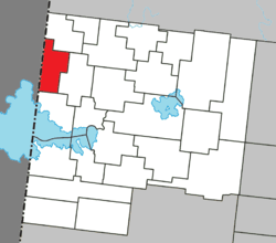 Location within Abitibi-Ouest RCM. | |
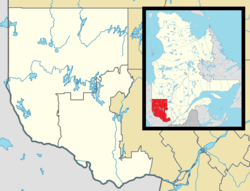 La Reine Location in western Quebec. | |
| Coordinates: 48°52′N 79°30′W / 48.867°N 79.500°WCoordinates: 48°52′N 79°30′W / 48.867°N 79.500°W[1] | |
| Country |
|
| Province |
|
| Region | Abitibi-Témiscamingue |
| RCM | Abitibi-Ouest |
| Settled | 1913 |
| Constituted | September 19, 1981 |
| Government[2] | |
| • Mayor | Jean-Guy Boulet |
| • Federal riding | Abitibi—Témiscamingue |
| • Prov. riding | Abitibi-Ouest |
| Area[2][3] | |
| • Total | 97.60 km2 (37.68 sq mi) |
| • Land | 97.35 km2 (37.59 sq mi) |
| Population (2011)[3] | |
| • Total | 340 |
| • Density | 3.5/km2 (9/sq mi) |
| • Pop 2006-2011 |
|
| • Dwellings | 163 |
| Time zone | EST (UTC−5) |
| • Summer (DST) | EDT (UTC−4) |
| Postal code(s) | J0Z 2L0 |
| Area code(s) | 819 |
| Highways | No major routes |
| Website |
www |
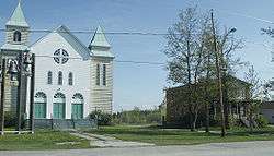
La Reine is a municipality in northwestern Quebec, Canada, on the La Reine River in the Abitibi-Ouest Regional County Municipality. It had a population of 340 in the Canada 2011 Census.
The place is named after La Reine Regiment (French for "the Queen"), that was founded in 1634 and fought under General Montcalm at the Battle of Carillon and Battle of Quebec.[1]
History
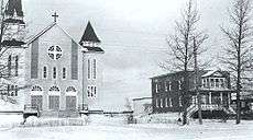
The first pioneers were from Berthier County and arrived in 1913, around the time when the National Transcontinental Railway was completed. The train station was first designed as Okiko, derived from the Algonquin name for the La Reine River Okikadosag Sibi. The following year the Mission of Saint-Philippe-de-La Reine was founded. In 1917, the place was incorporated as the United Township Municipality of La Reine-et-Desmeloizes-Partie-Ouest. In 1922, the village itself separated from the united township and formed the Village Municipality of La Reine.[1]
In 1949, the united township municipality changed its name and status to the Municipality of La Reine. In 1981, this municipality and the village municipality were rejoined.[1]
Demographics
Population
| Canada census – La Reine, Quebec community profile | |||
|---|---|---|---|
| 2011 | 2006 | 2001 | |
| Population: | 340 (-6.1% from 2006) | 362 (-6.2% from 2001) | 386 (-11.7% from 1996) |
| Land area: | 97.35 km2 (37.59 sq mi) | 97.35 km2 (37.59 sq mi) | 97.35 km2 (37.59 sq mi) |
| Population density: | 3.5/km2 (9.1/sq mi) | 3.7/km2 (9.6/sq mi) | 4.0/km2 (10/sq mi) |
| Median age: | 47.3 (M: 46.5, F: 48.5) | 43.0 (M: 42.0, F: 43.7) | 40.5 (M: 39.8, F: 42.0) |
| Total private dwellings: | 163 | 167 | 178 |
| Median household income: | $56,654 | $40,012 | $40,792 |
| References: 2011[3] 2006[4] 2001[5] | |||
| Historical Census Data - La Reine, Quebec[6] | ||||||||||||||||||||||||||
|---|---|---|---|---|---|---|---|---|---|---|---|---|---|---|---|---|---|---|---|---|---|---|---|---|---|---|
|
|
| ||||||||||||||||||||||||
Language
| Canada Census Mother Tongue - La Reine, Quebec[6] | ||||||||||||||||||
|---|---|---|---|---|---|---|---|---|---|---|---|---|---|---|---|---|---|---|
| Census | Total | French |
English |
French & English |
Other | |||||||||||||
| Year | Responses | Count | Trend | Pop % | Count | Trend | Pop % | Count | Trend | Pop % | Count | Trend | Pop % | |||||
| 2011 |
335 |
335 | |
100.00% | 0 | |
0.00% | 0 | |
0.00% | 0 | |
0.00% | |||||
| 2006 |
365 |
345 | |
94.52% | 10 | |
2.74% | 0 | |
0.00% | 10 | |
2.74% | |||||
| 2001 |
380 |
370 | |
97.37% | 0 | |
0.00% | 0 | |
0.00% | 10 | |
2.63% | |||||
| 1996 |
440 |
440 | n/a | 100.00% | 0 | n/a | 0.00% | 0 | n/a | 0.00% | 0 | n/a | 0.00% | |||||
Municipal council
- Mayor: Jacques Perreault
- Councillors: Réjean Bernard, Jean-Guy Boulet, Jean d'Avila Drainville, Jacques Michaud, Jean-François Royer, Yvonne Soulard
See also
References
- 1 2 3 4 "La Reine (Municipalité)" (in French). Commission de toponymie du Québec. Retrieved 2011-01-07.
- 1 2 "La Reine". Répertoire des municipalités (in French). Ministère des Affaires municipales, des Régions et de l'Occupation du territoire. Retrieved 2011-01-07.
- 1 2 3 "La Reine census profile". 2011 Census data. Statistics Canada. Retrieved 2011-01-07.
- ↑ "2006 Community Profiles". Canada 2006 Census. Statistics Canada. March 30, 2011. Retrieved 2014-03-21.
- ↑ "2001 Community Profiles". Canada 2001 Census. Statistics Canada. February 17, 2012. Retrieved 2014-03-21.
- 1 2 Statistics Canada: 1996, 2001, 2006, 2011 census
 |
Saint-Lambert | | ||
| Unorganized North Cochrane, Ontario | |
Dupuy | ||
| ||||
| | ||||
| Clerval |
| Towns | |
|---|---|
| Municipalities | |
| Townships | |
| Parishes | |
| Unorganized territories | |
| |