La Pomarède
| La Pomarède | ||
|---|---|---|
 | ||
| ||
 La Pomarède | ||
|
Location within Occitanie region  La Pomarède | ||
| Coordinates: 43°24′20″N 1°57′03″E / 43.4056°N 1.9508°ECoordinates: 43°24′20″N 1°57′03″E / 43.4056°N 1.9508°E | ||
| Country | France | |
| Region | Occitanie | |
| Department | Aude | |
| Arrondissement | Carcassonne | |
| Canton | Castelnaudary-Nord | |
| Intercommunality | Nord-Ouest Audois | |
| Government | ||
| • Mayor (2008–2014) | Jean-Jacques Régnier | |
| Area1 | 13.08 km2 (5.05 sq mi) | |
| Population (2008)2 | 164 | |
| • Density | 13/km2 (32/sq mi) | |
| Time zone | CET (UTC+1) | |
| • Summer (DST) | CEST (UTC+2) | |
| INSEE/Postal code | 11292 / 11400 | |
| Elevation |
188–375 m (617–1,230 ft) (avg. 243 m or 797 ft) | |
|
1 French Land Register data, which excludes lakes, ponds, glaciers > 1 km² (0.386 sq mi or 247 acres) and river estuaries. 2 Population without double counting: residents of multiple communes (e.g., students and military personnel) only counted once. | ||

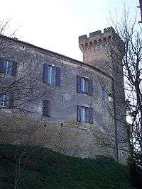
La Pomarède is a commune in the Aude department in southern France.
La Pomarède is centred on a partially preserved Cathar chateau (castle) which is now the property of the commune. The chateau contains the Maire (town hall), a post office and small library, a primary school, and a privately owned hotel and restaurant. There is also a parish church (Roman Catholic) and cemetery in the commune. Self-catering accommodation is available in gites a few minutes' walk from the chateau.
The major nearby towns are Castelnaudary (a garrison town, also in the Department of Aude) and Revel (in the neighbouring Department of Haute Garonne), both about twenty minutes' drive away.
Population
| Historical population | ||
|---|---|---|
| Year | Pop. | ±% |
| 1962 | 169 | — |
| 1968 | 175 | +3.6% |
| 1975 | 174 | −0.6% |
| 1982 | 165 | −5.2% |
| 1990 | 163 | −1.2% |
| 1999 | 158 | −3.1% |
| 2008 | 164 | +3.8% |
See also
References
| Wikimedia Commons has media related to La Pomarède. |