La Coulée, Manitoba
| La Coulée | |
|---|---|
| Unincorporated community | |
 | |
 La Coulée Location within Manitoba | |
| Coordinates: 49°39′30″N 96°35′00″W / 49.65833°N 96.58333°WCoordinates: 49°39′30″N 96°35′00″W / 49.65833°N 96.58333°W | |
| Country | Canada |
| Province | Manitoba |
| Rural municipality | Ste. Anne |
| Time zone | CST (UTC-6) |
La Coulée is a rural residential area in the Rural Municipality of Ste. Anne, south-eastern Manitoba, Canada, named for the creek running along its southern border.
Location
La Coulée is about 3 kilometres (1.9 mi) kilometers east of Sainte-Anne-des-Chênes, more commonly known as Ste. Anne. It is within 50 kilometres (31 mi) southeast of Winnipeg, and less than half an hour north from Steinbach. It is within the Rural Municipality of Ste. Anne and therefore its emergency services are provided by the rural municipality. The closest hospital is in Sainte-Anne as well as the nearest post-office.
Economy
Businesses in La Coulée include two hairdressers, a junkyard, a water dealer, a mechanic, and a golf course.
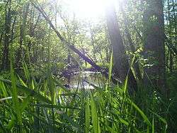
La Coulée, the creek along the community
| Cities | 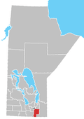 | |
|---|---|---|
| Towns | ||
| Villages | ||
| Rural municipalities | ||
| First Nations | ||
| Indian reserves | ||
| Unincorporated communities | ||
This article is issued from Wikipedia - version of the 11/25/2016. The text is available under the Creative Commons Attribution/Share Alike but additional terms may apply for the media files.