Korean War Veterans Parkway
| |
|---|---|
|
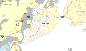
Map of Staten Island with Korean War Veterans Parkway highlighted in red | |
| Route information | |
| Maintained by NYSDOT | |
| Length: |
4.50 mi[1] (7.24 km) 0.7 mi (1.13 km) via Drumgoole Road (NY 909C) |
| Existed: | 1972[2] – present |
| History: | Named Richmond Parkway from 1972–1997[2] |
| Restrictions: | No commercial vehicles south of Arthur Kill Road |
| Major junctions | |
| South end: |
|
| North end: | Richmond Avenue in Latourette Park |
| Location | |
| Counties: | Richmond |
| Highway system | |

The Korean War Veterans Parkway is a parkway that traverses the South Shore of Staten Island, New York, in the United States. It officially begins at the Outerbridge Crossing toll plaza and runs from southwest to northeast to a merge with Drumgoole Boulevard in the island's Greenridge section. The parkway is designated New York State Route 909C (NY 909C), an unsigned reference route, which continues northeast along Drumgoole Boulevard for a short distance to its end at an intersection with Richmond Avenue. The westernmost 0.38 miles (0.61 km) of the parkway overlaps with NY 440.
The parkway opened in 1972 as the Richmond Parkway. It was officially renamed the Korean War Veterans Parkway in 1997; however, the highway is still widely known by the Richmond Parkway name. As originally planned, the parkway would have continued northeast to Sunnyside and connected to Wolfe's Pond Park on Staten Island's South Shore by way of a spur known as Wolfe's Pond Parkway. The section of the Richmond Parkway east of Richmond Avenue was cancelled sometime after the 1960s as a result of community opposition; likewise, Wolfe's Pond Parkway was cancelled in the 1970s.
Route description

The Korean War Veterans Parkway begins concurrent with NY 440 at the Outerbridge Crossing toll plaza east of the New Jersey state line on Staten Island. NY 440 and the parkway remain overlapped to Pleasant Plains,[1] where NY 440 splits from the parkway and heads north on the West Shore Expressway. Past NY 440, the four-lane parkway gains frontage roads as Drumgoole Boulevard begins to run along both sides of the highway. Not far to the east, the parkway runs along the southern edge of Bloomingdale Park and connects to Maguire Avenue by way of ramps leading to and from Drumgoole Boulevard. The parkway continues slightly northeastward through Pleasant Plains to Huguenot, serving Huguenot Avenue with southbound exit and northbound entrance ramps.[3]
From Huguenot Avenue, the highway takes a more pronounced northeasterly track through the neighborhoods of Woodrow and Annadale, meeting Arden Avenue by way of an interchange in the latter community. The parkway continues as a four-lane limited-access highway to Greenridge, where the road merges with the northern half of Drumgoole Boulevard to create a four-lane, two-way surface street with a Jersey barrier in the median. The Korean War Veterans Parkway ends at the merge;[3] however, NY 909C, the unsigned reference route designation for the parkway, continues to follow Drumgoole Boulevard to its end a short distance later at an intersection with Richmond Avenue.[1] Stubs intended to continue both directions of the parkway past Greenridge are present at the merge with Drumgoole Boulevard. The unused highways roughly parallel Drumgoole Boulevard, crossing over Richmond Avenue before abruptly becoming a small two-lane road just east of the overpasses. The road continues as a non-public asphalt roadway used for construction vehicles.[3]
History
The parkway that exists today represents less than half of the highway that was originally planned. From Richmond Avenue, the parkway would have continued northeast to Staten Island's Sunnyside neighborhood, where it would connect to the Staten Island Expressway. The 4.5-mile (7.2 km) section west of Richmond Avenue was constructed along Drumgoole Road from 1966 to 1972 and opened to traffic in late 1972.[2] As a result, the parkway's one-way service roads were named Drumgoole Road East and Drumgoole Road West. Drumgoole Road itself was named for Father John Drumgoole, the Irish-born founder of the Mission of the Immaculate Virgin, a Roman Catholic orphanage and monastery better known today as Mount Loretto.
In the late 1960s, intense community opposition erupted over the portion east of Richmond Avenue—much of it from environmentalists—because the parkway's planned route would have bisected the Staten Island Greenbelt and would have required the condemnation and razing of miles of private property. The 4.8-mile (7.7 km) section of the parkway between Richmond Avenue and the proposed Staten Island Expressway interchange ended up never being built, and the route was subsequently demapped. From time to time, proposals have been made to revive the aborted section of the parkway in response to steadily increasing traffic congestion on Staten Island. However, none of these proposals have received significant support from the island's elected officials or residents.[2]
Robert Moses had an interchange at the junction with the Staten Island Expressway (I-278) in Todt Hill built for the intention of using it for the terminus of the Richmond. However, this never came to be finished and the interchange was demolished in 2012 as part of a project to widen the Staten Island Expressway.[4]
Wolfe's Pond Parkway, a spur route connecting Richmond Parkway to Wolfe's Pond Park on Staten Island's South Shore, was proposed by Robert Moses in 1941. The highway never advanced past the planning stage, and it was ultimately cancelled in the 1970s.[5]
In 1997, the Richmond Parkway was officially renamed the Korean War Veterans Memorial Parkway; however, when signs announcing the change were erected, the word "Memorial" was inadvertently omitted.[2] The vast majority of Staten Islanders continue to refer to the parkway by its original name.
Exit list
The entire route is in the New York City borough of Staten Island (Richmond County). All exits are unnumbered.
| Location | mi[1][6] | km | Destinations | Notes | |
|---|---|---|---|---|---|
| Pleasant Plains | 0.00 | 0.00 | Tolled bridge | ||
| 0.20 | 0.32 | Park & Ride | Southbound exit only; other movements via NY 440 | ||
| 0.38 | 0.61 | Exit 2 on NY 440 | |||
| Huguenot | 0.60– 1.10 | 0.97– 1.77 | Maguire Avenue / Foster Road / Huguenot Avenue | Northbound exit and southbound entrance | |
| Maguire Avenue / Bloomingdale Road / Arthur Kill Road | Southbound exit and northbound entrance | ||||
| 2.10 | 3.38 | Foster Road / Hugenot Avenue | Southbound exit and northbound entrance | ||
| Annadale | 2.70– 3.20 | 4.35– 5.15 | Arden Avenue / Annadale Road | Northbound exit and southbound entrance | |
| Arden Avenue / Albee Avenue | Southbound exit and northbound entrance | ||||
| Greenridge | 3.60 | 5.79 | Richmond Avenue south | Northbound exit only | |
| 3.80 | 6.12 | Park & Ride | Parkway transitions to Drumgoole Road | ||
| 4.00 | 6.44 | Arthur Kill Road – Richmondtown | At-grade intersection | ||
| Latourette Park | 4.20 | 6.76 | At-grade intersection | ||
1.000 mi = 1.609 km; 1.000 km = 0.621 mi
| |||||
See also
-
.svg.png) New York Roads portal
New York Roads portal
References
- 1 2 3 4 "2007 Traffic Data Report for New York State" (PDF). New York State Department of Transportation. July 25, 2008. Retrieved July 17, 2009.
- 1 2 3 4 5 Anderson, Steve. "Korean War Veterans Parkway". NYCRoads. Retrieved March 18, 2010.
- 1 2 3 Google (December 9, 2007). "overview map of the Korean War Veterans Parkway" (Map). Google Maps. Google. Retrieved December 9, 2007.
- ↑ Dominowski, Michael (April 29, 2012). "Unused Staten Island overpasses being dismantled, and so is an era". Staten Island Advance. Staten Island, NY. Retrieved January 29, 2013.
- ↑ Anderson, Steve. "Wolfe's Pond Parkway". NYCRoads. Retrieved September 23, 2012.
- ↑ Google (January 6, 2016). "Korean War Veterans Parkway" (Map). Google Maps. Google. Retrieved January 6, 2016.
External links
- Korean War Veterans Parkway at Alps' Roads • New York State Highway Termini