Eastern Parkway
|
Eastern Parkway | |
|
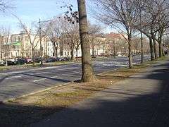
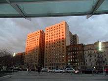
Near New York Avenue in Crown Heights | |
| Location | Brooklyn, New York City |
|---|---|
| Built | 1870 |
| Architect | Frederick Law Olmsted; Calvert Vaux |
| NRHP Reference # | 83001689 [1] |
| Added to NRHP | September 26, 1983 |
Eastern Parkway is a major boulevard that runs through a portion of the New York City borough of Brooklyn. The road begins at Grand Army Plaza and extends east, running parallel to Atlantic Avenue, along the crest of the moraine that separates northern from southern Long Island, to Ralph Avenue. There, it turns to the northeast, still following the moraine, until it terminates at Evergreen Cemetery [2] where the moraine takes a steep climb towards a peak at Ridgewood Reservoir.
History
Eastern Parkway is credited as the world's first parkway.[3][4] According to the New York City Department of Parks and Recreation's description of Eastern Parkway:
The world's first parkway was conceived by Frederick Law Olmsted and Calvert Vaux in 1866. The term parkway was coined by these designers as a landscaped road built expressly for 'pleasure-riding and driving' or scenic access to Prospect Park (also designed by Olmsted and Vaux). To these ends, commerce was restricted. The parkway was constructed from Grand Army Plaza to Ralph Avenue (the boundary of the City of Brooklyn) between 1870 and 1874. Olmsted and Vaux intended Eastern Parkway to be the Brooklyn nucleus of an interconnected park and parkway system for the New York area. The plan was never completed but their idea of bringing the countryside into the city influenced the construction of major parks and parkways in cities throughout the United States.[5]
The success of the special statutory commercial restrictions on this and other urban parkways inspired later, more general zoning schemes in New York and elsewhere. The parkway was planned as an important urban design element to create an amenity for a good neighborhood.
Like some later roads on Long Island, Eastern Parkway was designed to use land that was idle because it was high, rocky, and unsuited to farming. The presence of the road, however, made the area residentially desirable for people whose income derived from elsewhere. Thus it became inhabited in the next few decades, while land on slopes to the south and north continued to be used for farms into the 20th century, when the IRT Eastern Parkway Line subway line (2 3 4 5 trains) was built under the parkway. Many trees along the parkway bear plaques commemorating soldiers fallen in World War I.
Route description
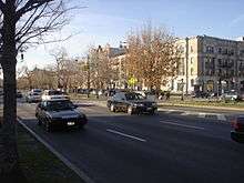
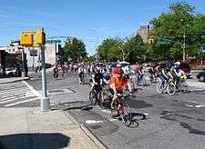
In the short westernmost portion, between Grand Army Plaza and Prospect Park (where it intersects with Prospect Park West, Flatbush Avenue, and Vanderbilt Avenue) and Washington Avenue, the thoroughfare consists of a broad, bidirectional avenue of six lanes, separated by a median from a narrow parallel side street on the north side. It passes Brooklyn Museum in this area. The section between Washington and Ralph Avenues has also a southern side street, separated by another median. Both medians have trees, benches, subway station entrance, and paths for pedestrians, and the southern one also has a bike path, part of the Brooklyn-Queens Greenway which runs south from the western end through Prospect Park to Ocean Parkway and east from the eastern end through Forest Park. The parkway passes Bedford, Rogers, and Nostrand Avenues in this fashion before passing Chabad world headquarters and the Jewish Children's Museum in Crown Heights. It continues east, crossing Utica and Ralph Avenues.
East of Ralph Avenue, the parkway is reduced to six lanes, heading in a northeasterly direction toward Bushwick Avenue. Here, Eastern Parkway officially becomes the Eastern Parkway Extension[6] (though signage saying this only appears northeast of Broadway) and curves northeast to intersect with Howard Avenue, Atlantic Avenue, Fulton Street, and Broadway. At Bushwick Avenue, the Extension becomes Vanderveer Street, a dead-end street.
Originally, Eastern Parkway east of Ralph Avenue continued down present-day Pitkin Avenue toward where Aqueduct Racetrack is today; the addresses along Pitkin Avenue follow directly from that of Eastern Parkway. Eastern Park, the home of the Brooklyn Dodgers before Ebbets Field, was located along Pitkin Avenue when that was part of Eastern Parkway.
Other attractions and notable buildings along Eastern Parkway include the Brooklyn Public Library central branch, the Brooklyn Botanical Gardens, 770 Eastern Parkway, Zion Triangle and the Jewish Children's Museum. The parkway is the route of the West Indian Day Parade, a festive annual celebration taking place around Labor Day.
References
- ↑ National Park Service (2007-01-23). "National Register Information System". National Register of Historic Places. National Park Service.
- ↑ Google Maps
- ↑ Find a Grave
- ↑ Landmarks Preservation Commission
- ↑ New York City Department of Parks and Recreation
- ↑ Eastern Parkway