Grand Central Parkway
| |
|---|---|
|
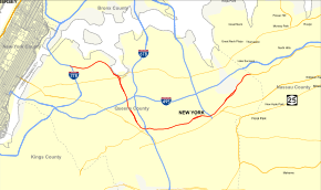
Map of New York City with Grand Central Parkway highlighted in red | |
| Route information | |
| Maintained by NYSDOT | |
| Length: | 14.61 mi[1] (23.51 km) |
| Existed: | 1936 – present |
| Restrictions: | No commercial vehicles east of I-278 |
| Major junctions | |
| West end: |
|
| East end: |
|
| Location | |
| Counties: | Queens |
| Highway system | |

The Grand Central Parkway (GCP) is a 14.61-mile (23.51 km) long parkway that stretches from the Triborough Bridge in New York City to Nassau County on Long Island. At the Queens–Nassau border, it becomes the Northern State Parkway, which runs across the northern part of Long Island through Nassau County and into Suffolk County, where it ends in Hauppauge. The westernmost stretch (from the Triborough Bridge to exit 4) also carries a short stretch of Interstate 278 (I-278). The parkway runs through Queens and passes the Cross Island Parkway, Long Island Expressway, LaGuardia Airport and Citi Field, home of the New York Mets. The parkway is designated New York State Route 907M (NY 907M), an unsigned reference route. Despite its name, the Grand Central Parkway was not named after Grand Central Terminal.
The Grand Central Parkway has a few unique distinctions. First, it is apparently the only parkway in New York City to carry an elliptical black-on-white design for its trailblazer. Parkways throughout The Bronx, Manhattan, and Staten Island use the state-standard design, while the Belt system parkways use a modified version of the Long Island regional parkway shield with the Montauk Point Lighthouse logo. Second, it is one of the few parkways in the state to allow truck traffic to any extent. The section shared with I-278 allows for small trucks—larger ones still cannot pass under the intentionally designed low underpasses. Oversize trucks must travel on Astoria Boulevard, the local service road, to reach the bridge.
Route description

The Grand Central Parkway begins at exit 44 off eastbound I-278 (the Brooklyn–Queens Expressway) in the Astoria section of Queens. The parkway proceeds east past St. Michaels Cemetery, entering exit 5, which serves 82nd Street and Astoria Boulevard in East Elmhurst, also connecting to the Marine Air Terminal and Terminal A of Fiorello LaGuardia Airport. After crossing over 82nd Street and Ditmars Boulevard, the parkway enters the airport area, passing south of runway 4-22. A short distance to the northeast, exit 6 arrives at an interchange with 94th Street and the access to Terminal B of the airport. Immediately after exit 7 forks northward on a ramp to the airport's terminals B, C and D. After exit 7, the Grand Central bends southeast and away from LaGuardia Airport, paralleling the Long Island Sound into the eastbound only exit 8, which serves 111th Street.[2]
Entering the Corona section of Queens, the Grand Central enters exit 9, which serves NY 25A (Northern Boulevard) just west of Citi Field. The Grand Central then proceeds south, crossing under the Long Island Rail Road's Port Washington Branch and soon into Flushing Meadows-Corona Park. Through the park, the parkway passes west of Arthur Ashe Stadium, the Queens Zoo and the Unisphere before entering exit 10, a cloverleaf interchange with the Long Island Expressway (I-495). Soon crossing into Forest Hills, the parkway continues through Flushing Meadows-Corona Park, passing Meadow Lake, entering exit 11, connecting to 69th Road and Jewel Avenue in [in Forest Hills]. After that interchange, the parkway bends southeast through Forest Hills, passing Willow Lake and exit 12, which connects to NY 25 (Queens Boulevard) via 78th Avenue.[2]
The Grand Central continues its bend, now proceeding eastward over Corona Yard, entering the Kew Gardens Interchange (exits 13, 14 and 15), connecting I-678 (the Van Wyck Expressway), Union Turnpike and the Jackie Robinson Parkway in Kew Gardens. After the Kew Gardens Interchange, the Grand Central Parkway continues east into the Briarwood section of Queens, where exit 16 connects to Parsons Boulevard via a service road. After crossing through the developed neighborhood of Briarwood, the parkway enters Jamaica Hills, passing south of Queens Hospital near 164th Street. Proceeding westbound, an exit (exit 17) is present, connecting to 168th Street, while eastbound, exit 18 connects the Grand Central to Utopia Parkway.[2]
At the interchange with Utopia Parkway, the Grand Central passes south of St. John's University, soon winding northeast into exit 19, which serves 188th Street in Jamaica Estates. After exit 19, the parkway winds eastward into Cunningham Park, where it enters exit 20, which serves Francis Lewis Boulevard and exit 21, which connects to the Clearview Expressway (I-295) and its southern terminus. The parkway leaves Cunningham Park, entering the Bellerose section of Queens, entering exit 22, which connects to Union Turnpike via Stronghurst Avenue. The route then enters Alley Pond Park, where it interchanges with the Cross Island Parkway and Winchester Boulevard. After the interchange, the Grand Central passes west of Creedmoor Hospital, winding northeast into exit 24, which serves Little Neck Parkway before winding northeast to the Nassau County line in Little Neck. At this crossing, the parkway changes names to the Northern State Parkway, which continues east towards Hauppauge.[2]
History
The Grand Central Parkway was first planned in 1922, as a connection between Queens Boulevard and Nassau County, helping city dwellers reach Jones Beach more easily. The original section is a parallel route to the pre-existing Union Turnpike, which was a congested street. Construction for the Parkway began in 1931, and the parkway was widened in 1961 in preparation for the 1964 New York World's Fair in Flushing Meadows–Corona Park.
Exit list
The entire route is in the New York City borough of Queens.
| Location | mi[1] | km | Exit | Destinations | Notes |
|---|---|---|---|---|---|
| Astoria | 0.00 | 0.00 | – | West end of concurrency with I-278 | |
| 45 | 31st Street / Astoria Boulevard (I-278 Truck) | No exit number eastbound; former exit 3 | |||
| Astoria–East Elmhurst | 0.80– 1.34 | 1.29– 2.16 | 4 | East end of concurrency with I-278; exit 42 on I-278; no exit number eastbound | |
| East Elmhurst | 1.34 | 2.16 | 5 | Serves Delta Shuttle to Chicago and Washington | |
| 2.26 | 3.64 | 6 | Westbound exit is part of exit 7 | ||
| 2.51 | 4.04 | 7 | All other airlines, including Delta Shuttle to Boston | ||
| 3.55 | 5.71 | 8 | 111th Street | Eastbound exit only | |
| Corona | 3.79 | 6.10 | 9W | Westbound exit and eastbound entrance | |
| 9E | Exits 13B–C on I-678 | ||||
| Flushing Meadows– Corona Park | 4.39 | 7.07 | 9P | Flushing Meadows–Corona Park, BJK Tennis Center | No eastbound exit |
| 5.10 | 8.21 | 10 | Signed as 10W (west) and 10E (east); exits 22A–B on I-495 | ||
| 5.94 | 9.56 | 11 | 69th Road / Jewel Avenue | Signed as 11W (west) and 11E (east) westbound | |
| 6.50 | 10.46 | 12 | Eastbound exit only | ||
| Kew Gardens Hills | 7.19 | 11.57 | 13W | East end of J.R. Parkway; exit 8 on J.R. Parkway | |
| 13S | Eastbound exit and westbound entrance; exit 10 on I-678 | ||||
| 7.53 | 12.12 | 14 | Union Turnpike / Main Street | Eastbound exit and westbound entrance | |
| 15 | Westbound exit and eastbound entrance | ||||
| Briarwood | 8.11 | 13.05 | 16 | Parsons Boulevard / 164th Street | Eastbound exit only |
| Jamaica Hills–Hillcrest | 8.64 | 13.90 | 17 | 168th Street | Westbound exit only; alternate route to I-678 |
| 9.13 | 14.69 | 18 | Utopia Parkway | Westbound exit is part of exit 17 | |
| Jamaica Estates– Holliswood | 9.83 | 15.82 | 19 | 188th Street | |
| Cunningham Park | 10.57– 10.86 | 17.01– 17.48 | 20 | Francis Lewis Boulevard | Signed as 20B (south) and 20A (north) |
| 11.10 | 17.86 | 21 | NYC's only stack interchange; exit 1 on I-295 | ||
| Bellerose | 11.93 | 19.20 | 22 | Union Turnpike | Westbound exit is part of exit 23 |
| Glen Oaks | 12.56 | 20.21 | 23 | Signed as 23S (south) and 23N (north); exit 29 on Cross Island Parkway | |
| Glen Oaks–Little Neck | 13.67 | 22.00 | 24 | Little Neck Parkway | |
| 14.61 | 23.51 | – | Continuation into Nassau County | ||
1.000 mi = 1.609 km; 1.000 km = 0.621 mi
| |||||
See also
.svg.png) New York Roads portal
New York Roads portal
References
- 1 2 "2007 Traffic Data Report for New York State" (PDF). New York State Department of Transportation. July 25, 2008. Retrieved July 17, 2009.
- 1 2 3 4 Microsoft; Nokia (June 21, 2012). "overview map of the Grand Central Parkway" (Map). Bing Maps. Microsoft. Retrieved June 21, 2012.
External links
- Grand Central Parkway at Alps' Roads • New York State Highway Termini
- Grand Central Parkway @ NYCROADS.com
- Grand Central Parkway (Greater New York Roads)
- Grand Central Parkway (Jeff's Parkway Site, Photo Gallery)