Harlem River Drive
| |
|---|---|
| 369th Harlem Hellfighters Drive | |
|
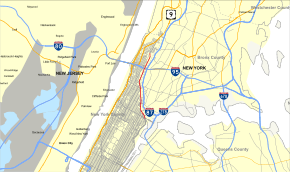
Map of New York City with Harlem River Drive highlighted in red | |
| Route information | |
| Maintained by NYSDOT | |
| Length: | 4.20 mi[1] (6.76 km) |
| Existed: | 1964 – present |
| Restrictions: | No commercial vehicles |
| Major junctions | |
| South end: |
|
|
Willis Avenue Bridge in East Harlem Third Avenue Bridge in East Harlem | |
| North end: | 10th Avenue / Dyckman Street in Inwood–Fort George |
| Location | |
| Counties: | New York |
| Highway system | |

The Harlem River Drive, officially designated the 369th Harlem Hellfighters Drive, is a 4.20-mile (6.76 km) long north–south parkway in the New York City borough of Manhattan. It runs along the west bank of the Harlem River from the Triborough Bridge in East Harlem to 10th Avenue in Inwood, where the parkway ends and the road continues north as Dyckman Street. The portion of the Harlem River Drive from the Triborough Bridge to the Alexander Hamilton Bridge is a limited-access highway. South of the Triborough Bridge, the parkway continues toward lower Manhattan as FDR Drive. All of the Harlem River Drive is designated New York State Route 907P (NY 907P), an unsigned reference route. The parkway opened to traffic in 1964. The parkway's ceremonial designation is in honor of the 369th Infantry Regiment, also known as the Harlem Hellfighters.
Route description
The Harlem River Drive begins at exit 17 of the FDR Drive in East Harlem section of Manhattan. The parkway crosses under 125th Street alongside the Harlem River. Bending to the northwest, the Harlem River Drive crosses under Willis Avenue, passing west of the Willis Avenue Bridge. Proceeding southbound, exit 19 is present, connecting to 125th Street and the Willis Avenue Bridge. The Harlem River Drive proceeding northwest, crosses under the Third Avenue Bridge, reaching exit 21 northbound, a junction for 135th Street. Southbound, exit 20 connects to Park Avenue. Continuing northward, the Harlem River Drive continues north under the Madison Avenue Bridge. Southbound, the Harlem River Drive meets exit 22, a junction to 142nd Street and Fifth Avenue.[2]
Crossing under 145th Street, the Harlem River Drive passes east of the 145th Street subway station on the IRT Lenox Avenue Line (3 train). It then passes directly east of the Lenox Yard and the Harlem – 148th Street station. The Harlem River Drive crosses under the Macombs Dam Bridge, 155th Street, and Seventh Avenue before crossing northbound exit 23, a left exit to Frederick Douglass Boulevard. Then, the parkway goes east of the Polo Grounds site and merges with the southbound exit 23, an exit to Frederick Douglass Boulevard and to a junction with the Harlem River Driveway, which goes south to 155th Street. Shortly after, Harlem River Drive enters exit 24, a four-lane viaduct that rises from the parkway to connect to the George Washington Bridge via I-95 and US 1 along the Trans-Manhattan Expressway, as well to Amsterdam Avenue in Washington Heights.[2]
The Harlem River Drive continues northeast as a four-lane parkway. Crossing under the Alexander Hamilton Bridge, the Harlem River Drive crosses through High Bridge Park before turning away from the Harlem River in Inwood. The four-lane arterial continues north through Manhattan, entering a junction with Dyckman Street and Tenth Avenue, which is the northern end of the Harlem River Drive.[2]
History
_crop.jpg)
The Drive originated as the Harlem River Speedway, built from 1894 to 1898 and opened in July of that year, for the exclusive use of horse-drawn carriages and those on horseback - bicyclists were specifically excluded, as were sulkies and drays. The Speedway ran from West 155th Street to Dyckman Street, and soon became a tourist destination, where visitors watched carriage races and boat races on the river. Rich New Yorkers used the Speedway to train their horses and size up those of their friends and competitors.[3][4] In 1919, motorists were allowed on the Speedway, which was paved in 1922.[3]
Master builder Robert Moses envisioned the Harlem River Drive as a six-lane road linking the George Washington Bridge and the East River Drive (now the FDR Drive) north of East 125th Street. Traffic from the Triborough Bridge and the several Harlem River bridges joining the Major Deegan Expressway in the Bronx feed into the drive. Sections of the old speedway in the path of the highway were incorporated into the new highway. The cost of the Harlem River Drive is estimated at over $11.7 million and nearly $7 million in acquired lands.[5] Construction was completed in 1964.
In 2003, the New York State Department of Transportation ceremoniously designated the parkway as the "369th Harlem Hellfighters Drive" in honor of the all-black regiment that fought to defend France during World War I.
Founded in 2010, the Manhattan Waterfront Greenway runs between the river and the drive, from 155th to Dyckman Streets, in a portion of Highbridge Park which had been abandoned and fenced off approximately half a century.[6]
Exit list
The entire route is in the New York City borough of Manhattan.
| Location | mi[1][7] | km | Exit | Destinations | Notes |
|---|---|---|---|---|---|
| East Harlem | 0.00 | 0.00 | – | Continuation beyond RFK Bridge | |
| 17 | Northbound entrance under construction | ||||
| 18 | Northbound exit only | ||||
| 0.10– 0.60 | 0.16– 0.97 | 19 | 2nd Avenue / East 125th Street | Northbound exit closed until 2017[8] | |
| 0.60 | 0.97 | – | Third Avenue Bridge | Southbound entrance only | |
| 0.68– 0.90 | 1.09– 1.45 | 20 | Park Avenue / East 132nd Street | Southbound exit and entrance | |
| 0.71 | 1.14 | 21 | East 135th Street / Madison Avenue Bridge | Northbound exit only | |
| 0.90– 1.40 | 1.45– 2.25 | 22 | 5th Avenue / West 142nd Street | No northbound exit | |
| Washington Heights | 2.10– 2.80 | 3.38– 4.51 | 23 | Frederick Douglass Boulevard / West 155th Street | Southbound access via Harlem River Driveway |
| Highbridge Park | 3.23 | 5.20 | 24 | Northbound exit and southbound entrance; exit 1B on I-95 / US 1 | |
| Inwood–Fort George | 4.20 | 6.76 | – | Dyckman Street / 10th Avenue | At-grade intersection |
1.000 mi = 1.609 km; 1.000 km = 0.621 mi
| |||||
See also
.svg.png) New York Roads portal
New York Roads portal
References
Notes
- 1 2 "2007 Traffic Data Report for New York State" (PDF). New York State Department of Transportation. July 25, 2008. Retrieved May 29, 2009.
- 1 2 3 Microsoft; Nokia (October 7, 2012). "overview map of the Harlem River Drive" (Map). Bing Maps. Microsoft. Retrieved October 7, 2012.
- 1 2 Robinson, Lauren. "How Harlem River Speedway Became Harlem River Drive" Museum of the City of New York (February 28, 2012)
- ↑ "Harlem River Drive: An Historic Overview". nycroads.com. Eastern Roads. Retrieved 7 October 2011.
- ↑ "Harlem River Drive". NYC Roads. Retrieved 1 December 2013.
- ↑ "Manhattan Waterfront Greenway". New York City Department of City Planning. 2010. Retrieved April 2, 2010.
- ↑ Google (January 5, 2015). "Harlem River Drive" (Map). Google Maps. Google. Retrieved January 5, 2015.
- ↑ Solis, Gustavo. "125th Street Faces 3 Years of Detours Amid Harlem River Drive Repairs" DNAinfo (November 10, 2014)
External links
| Wikimedia Commons has media related to Harlem River Drive. |
- Harlem River Drive at Alps' Roads • New York State Highway Termini
- NYCRoads.com – Harlem River Drive
- How Harlem River Speedway Became Harlem River Drive from the Museum of the City of New York Collections blog