Keyapaha, South Dakota
| Keyapaha, South Dakota | |
|---|---|
| Unincorporated community | |
 Keyapaha, South Dakota | |
| Coordinates: 43°06′34″N 100°08′16″W / 43.10944°N 100.13778°WCoordinates: 43°06′34″N 100°08′16″W / 43.10944°N 100.13778°W | |
| Country | United States |
| State | South Dakota |
| County | Tripp |
| Elevation | 2,300 ft (700 m) |
| Time zone | Central (CST) (UTC-6) |
| • Summer (DST) | CDT (UTC-5) |
| Area code(s) | 605 |
| GNIS feature ID | 1261116[1] |
Keyapaha is an unincorporated community in Tripp County, South Dakota, United States. Keyapaha is southwest of Colome and south of New Witten.
The community took its name from the Keya Paha River.[2] The name "Keya Paha" is taken from the Sioux language; literally translated, it means "turtle hill".[3]
References
- ↑ "US Board on Geographic Names". United States Geological Survey. 2007-10-25. Retrieved 2008-01-31.
- ↑ Federal Writers' Project (1940). South Dakota place-names, v.1-3. University of South Dakota. p. 45.
- ↑ Gannett, Henry (1905). The Origin of Certain Place Names in the United States. Govt. Print. Off. p. 174.
Municipalities and communities of Tripp County, South Dakota, United States | ||
|---|---|---|
| Cities | 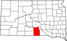 | |
| Town | ||
| CDP | ||
| Unincorporated communities | ||
| Indian reservation | ||
| Footnotes | ‡This populated place also has portions in an adjacent county or counties | |
This article is issued from Wikipedia - version of the 10/15/2016. The text is available under the Creative Commons Attribution/Share Alike but additional terms may apply for the media files.