Hamill, South Dakota
| Hamill, South Dakota | |
|---|---|
| CDP | |
 Location in Tripp County and the state of South Dakota | |
| Coordinates: 43°35′44″N 99°40′57″W / 43.59556°N 99.68250°WCoordinates: 43°35′44″N 99°40′57″W / 43.59556°N 99.68250°W | |
| Country | United States |
| State | South Dakota |
| County | Tripp |
| Area | |
| • Total | 1.2 sq mi (3.3 km2) |
| • Land | 1.2 sq mi (3.2 km2) |
| • Water | 0 sq mi (0.1 km2) |
| Elevation | 1,762 ft (537 m) |
| Population (2010) | |
| • Total | 11 |
| • Density | 9.2/sq mi (3.3/km2) |
| Time zone | Central (CST) (UTC-6) |
| • Summer (DST) | CDT (UTC-5) |
| ZIP code | 57534 |
| Area code(s) | 605 |
| FIPS code | 46-26660[1] |
| GNIS feature ID | 1255403[2] |
Hamill is a census-designated place (CDP) in Tripp County, South Dakota, United States. The population was 11 at the 2010 census.
Geography
According to the United States Census Bureau, the CDP has a total area of 1.2 square miles (3.1 km2), of which 1.2 square miles (3.1 km2) is land and 0.04 square miles (0.10 km2) (2.40%) is water.
Demographics
As of the census[1] of 2000, there were 11 people, 5 households, and 3 families residing in the CDP. The population density was 9.0 people per square mile (3.5/km²). There were 7 housing units at an average density of 5.7/sq mi (2.2/km²). The racial makeup of the CDP was 100.00% White.
There were 5 households out of which 20.0% had children under the age of 18 living with them, 40.0% were married couples living together, and 40.0% were non-families. 40.0% of all households were made up of individuals and 20.0% had someone living alone who was 65 years of age or older. The average household size was 2.20 and the average family size was 3.00.
In the CDP the population was spread out with 18.2% under the age of 18, 27.3% from 25 to 44, 9.1% from 45 to 64, and 45.5% who were 65 years of age or older. The median age was 62 years. For every 100 females there were 83.3 males. For every 100 females age 18 and over, there were 80.0 males.
The median income for a household in the CDP was $42,500, and the median income for a family was $42,500. Males had a median income of $15,000 versus $16,250 for females. The per capita income for the CDP was $11,833. None of the population or families were below the poverty line.
History
Originally named Roseland, Hamill was renamed for Gail Hamill the pioneer merchant, postmaster and banker in town.[3] In 1909 the Milwaukee Road surveyed a route from Oacoma, South Dakota through Roseland and beyond but the line was never built.[4]
References
- 1 2 "American FactFinder". United States Census Bureau. Retrieved 2008-01-31.
- ↑ "US Board on Geographic Names". United States Geological Survey. 2007-10-25. Retrieved 2008-01-31.
- ↑ Federal Writers' Project (1940). South Dakota place-names, v.1-3. University of South Dakota. p. 40.
- ↑ Linnaus, Dr. Vernon F and Bartels, Michael M.. Rails to the Rosebud. South Platte Press, 2008, p. 41.
Municipalities and communities of Tripp County, South Dakota, United States | ||
|---|---|---|
| Cities | 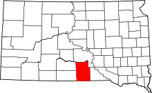 | |
| Town | ||
| CDP | ||
| Unincorporated communities | ||
| Indian reservation | ||
| Footnotes | ‡This populated place also has portions in an adjacent county or counties | |