Winner, South Dakota
| Winner, South Dakota | |
|---|---|
| City | |
|
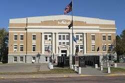
Tripp County courthouse in Winner | |
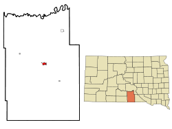 Location in Tripp County and the state of South Dakota | |
| Coordinates: 43°22′26″N 99°51′28″W / 43.37389°N 99.85778°WCoordinates: 43°22′26″N 99°51′28″W / 43.37389°N 99.85778°W | |
| Country | United States |
| State | South Dakota |
| County | Tripp |
| Incorporated | 1911[1] |
| Area[2] | |
| • Total | 2.20 sq mi (5.70 km2) |
| • Land | 2.20 sq mi (5.70 km2) |
| • Water | 0 sq mi (0 km2) |
| Elevation | 1,969 ft (600 m) |
| Population (2010)[3] | |
| • Total | 2,897 |
| • Estimate (2015)[4] | 2,825 |
| • Density | 1,316.8/sq mi (508.4/km2) |
| Time zone | Central (CST) (UTC-6) |
| • Summer (DST) | CDT (UTC-5) |
| ZIP code | 57580 |
| Area code(s) | 605 |
| FIPS code | 46-72180[5] |
| GNIS feature ID | 1266939[6] |
| Website | winnersd.org |
Winner is a city in Tripp County, South Dakota, United States. The population was 2,897 at the 2010 census. It is the county seat of Tripp County.[7] Winner also serves as the administrative center of neighboring Todd County, which does not have its own county seat.[8] The nearest airport is Winner Regional Airport.
Winner was laid out in 1909, and named for the fact the town had emerged the "winner" as the county's most successful trading point.[9]
Geography
According to the United States Census Bureau, the city has a total area of 2.20 square miles (5.70 km2), all land.[2]
Climate
Winner, located in the south central part of the state, features a climate type (Köppen Dfa) often described as a hot summer humid continental climate. Winters average below the −3 °C (26.6 °F) persistent snow line isotherm, and Summers average above 22 °C (72 °F) Köppen hot summer isotherm. The climate features nearly even four seasons, typical of its classification. The all-time high temperature is 112 °F (44 °C), set in 2003 and 1965, and the all-time low temperature is −29 °F (−34 °C), set in 1989.
| Climate data for Winner, South Dakota | |||||||||||||
|---|---|---|---|---|---|---|---|---|---|---|---|---|---|
| Month | Jan | Feb | Mar | Apr | May | Jun | Jul | Aug | Sep | Oct | Nov | Dec | Year |
| Record high °F (°C) | 73 (23) |
78 (26) |
88 (31) |
99 (37) |
100 (38) |
109 (43) |
112 (44) |
112 (44) |
105 (41) |
96 (36) |
86 (30) |
74 (23) |
112 (44) |
| Average high °F (°C) | 34 (1) |
38 (3) |
48 (9) |
60 (16) |
71 (22) |
81 (27) |
88 (31) |
87 (31) |
78 (26) |
64 (18) |
47 (8) |
34 (1) |
60.8 (16.1) |
| Average low °F (°C) | 12 (−11) |
15 (−9) |
23 (−5) |
34 (1) |
47 (8) |
57 (14) |
63 (17) |
60 (16) |
50 (10) |
37 (3) |
25 (−4) |
14 (−10) |
36.4 (2.5) |
| Record low °F (°C) | −27 (−33) |
−27 (−33) |
−18 (−28) |
7 (−14) |
20 (−7) |
34 (1) |
40 (4) |
39 (4) |
24 (−4) |
6 (−14) |
−12 (−24) |
−29 (−34) |
−29 (−34) |
| Average precipitation inches (mm) | 0.52 (13.2) |
0.65 (16.5) |
1.54 (39.1) |
2.72 (69.1) |
3.76 (95.5) |
3.91 (99.3) |
2.94 (74.7) |
2.23 (56.6) |
2.24 (56.9) |
1.87 (47.5) |
0.97 (24.6) |
0.61 (15.5) |
23.96 (608.5) |
| Source: [10] | |||||||||||||
| Winner, South Dakota | ||||||||||||||||||||||||||||||||||||||||||||||||||||||||||||
|---|---|---|---|---|---|---|---|---|---|---|---|---|---|---|---|---|---|---|---|---|---|---|---|---|---|---|---|---|---|---|---|---|---|---|---|---|---|---|---|---|---|---|---|---|---|---|---|---|---|---|---|---|---|---|---|---|---|---|---|---|
| Climate chart (explanation) | ||||||||||||||||||||||||||||||||||||||||||||||||||||||||||||
| ||||||||||||||||||||||||||||||||||||||||||||||||||||||||||||
| ||||||||||||||||||||||||||||||||||||||||||||||||||||||||||||
Demographics
| Historical population | |||
|---|---|---|---|
| Census | Pop. | %± | |
| 1920 | 2,000 | — | |
| 1930 | 2,220 | 11.0% | |
| 1940 | 2,426 | 9.3% | |
| 1950 | 3,252 | 34.0% | |
| 1960 | 3,705 | 13.9% | |
| 1970 | 3,789 | 2.3% | |
| 1980 | 3,472 | −8.4% | |
| 1990 | 3,354 | −3.4% | |
| 2000 | 3,137 | −6.5% | |
| 2010 | 2,897 | −7.7% | |
| Est. 2015 | 2,825 | [11] | −2.5% |
| U.S. Decennial Census[12] 2015 Estimate[4] | |||
2010 census
As of the census[3] of 2010, there were 2,897 people, 1,328 households, and 717 families residing in the city. The population density was 1,316.8 inhabitants per square mile (508.4/km2). There were 1,547 housing units at an average density of 703.2 per square mile (271.5/km2). The racial makeup of the city was 82.1% White, 0.2% African American, 14.0% Native American, 0.3% Asian, 0.3% from other races, and 3.2% from two or more races. Hispanic or Latino of any race were 1.4% of the population.
There were 1,328 households of which 24.2% had children under the age of 18 living with them, 39.5% were married couples living together, 10.9% had a female householder with no husband present, 3.5% had a male householder with no wife present, and 46.0% were non-families. 42.5% of all households were made up of individuals and 22.9% had someone living alone who was 65 years of age or older. The average household size was 2.08 and the average family size was 2.85.
The median age in the city was 45.6 years. 21.4% of residents were under the age of 18; 7.5% were between the ages of 18 and 24; 20.2% were from 25 to 44; 26.2% were from 45 to 64; and 24.6% were 65 years of age or older. The gender makeup of the city was 47.4% male and 52.6% female.
2000 census
As of the census[5] of 2000, there were 3,137 people, 1,359 households, and 803 families residing in the city. The population density was 2,030.6 people per square mile (786.5/km²). There were 1,526 housing units at an average density of 987.8 per square mile (382.6/km²). The racial makeup of the city was 89.35% White, 0.06% African American, 9.15% Native American, 0.06% Asian, 0.10% from other races, and 1.28% from two or more races. Hispanic or Latino of any race were 0.70% of the population.
There were 1,359 households out of which 26.3% had children under the age of 18 living with them, 47.8% were married couples living together, 7.4% had a female householder with no husband present, and 40.9% were non-families. 36.9% of all households were made up of individuals and 21.1% had someone living alone who was 65 years of age or older. The average household size was 2.24 and the average family size was 2.93.
In the city the population was spread out with 24.9% under the age of 18, 6.1% from 18 to 24, 24.4% from 25 to 44, 19.5% from 45 to 64, and 25.2% who were 65 years of age or older. The median age was 42 years. For every 100 females there were 91.5 males. For every 100 females age 18 and over, there were 84.9 males.
As of 2000 the median income for a household in the city was $26,277, and the median income for a family was $38,472. Males had a median income of $26,858 versus $20,613 for females. The per capita income for the city was $15,717. About 10.7% of families and 16.0% of the population were below the poverty line, including 16.0% of those under age 18 and 18.8% of those age 65 or over.
Notable people
- Frank Leahy, the Notre Dame coach who took the Fighting Irish to several national championships
- Delores Taylor, the co-creator and star (as Jean) of the Billy Jack films, was born and raised in Winner and the Billy Jack films were due in part to the poor treatment Native Americans received by some of the residents of Winner.
- Bob Barker, former host of "The Price Is Right.
References
- ↑ "SD Towns" (PDF). South Dakota State Historical Society. Retrieved 2010-02-17.
- 1 2 "US Gazetteer files 2010". United States Census Bureau. Retrieved 2012-06-21.
- 1 2 "American FactFinder". United States Census Bureau. Retrieved 2012-06-21.
- 1 2 "Population Estimates". United States Census Bureau. Retrieved June 7, 2016.
- 1 2 "American FactFinder". United States Census Bureau. Retrieved 2008-01-31.
- ↑ "US Board on Geographic Names". United States Geological Survey. 2007-10-25. Retrieved 2008-01-31.
- ↑ "Find a County". National Association of Counties. Retrieved 2011-06-07.
- ↑ , accessed February 5, 2006.
- ↑ Federal Writers' Project (1940). South Dakota place-names, v.1-3. University of South Dakota. p. 69.
- ↑ "Winner, SD Monthyl Averages". The Weather Channel. Retrieved December 4, 2011.
- ↑ "Annual Estimates of the Resident Population for Incorporated Places: April 1, 2010 to July 1, 2015". Retrieved July 2, 2016.
- ↑ United States Census Bureau. "Census of Population and Housing". Retrieved October 20, 2014.
External links
Municipalities and communities of Todd County, South Dakota, United States | ||
|---|---|---|
| City | 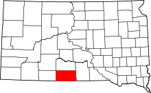 | |
| Town | ||
| CDPs |
| |
| Unincorporated communities | ||
| Indian reservation | ||
| Footnotes | ‡This populated place also has portions in an adjacent county or counties | |
Municipalities and communities of Tripp County, South Dakota, United States | ||
|---|---|---|
| Cities |  | |
| Town | ||
| CDP | ||
| Unincorporated communities | ||
| Indian reservation | ||
| Footnotes | ‡This populated place also has portions in an adjacent county or counties | |