Ideal, South Dakota
| Ideal | |
|---|---|
| Unincorporated community | |
 Ideal  Ideal Location within the state of South Dakota | |
| Coordinates: 43°32′36″N 99°55′17″W / 43.54333°N 99.92139°WCoordinates: 43°32′36″N 99°55′17″W / 43.54333°N 99.92139°W | |
| Country | United States |
| State | South Dakota |
| County | Tripp |
| Elevation | 1,886 ft (575 m) |
| Time zone | Central (CST) (UTC-6) |
| • Summer (DST) | CDT (UTC-5) |
| ZIP codes | 57541 |
| GNIS feature ID | 1266832[1] |
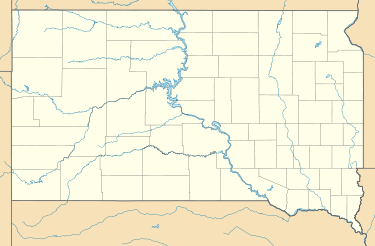
Ideal is an unincorporated community in northern Tripp County, South Dakota, United States, named for its superb farmland. It lies north of the city of Winner, the county seat.[2] Its elevation is 1,886 feet (575 m).[1]
Ideal's town site was considered to be "ideal" for farming, hence the name.[3]
References
- 1 2 "Ideal, South Dakota". Geographic Names Information System. United States Geological Survey. Retrieved 2008-03-04.
- ↑ Rand McNally. The Road Atlas '05. Chicago: Rand McNally, 2005, p. 93.
- ↑ Federal Writers' Project (1940). South Dakota place-names, v.1-3. University of South Dakota. p. 43.
Municipalities and communities of Tripp County, South Dakota, United States | ||
|---|---|---|
| Cities | 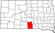 | |
| Town | ||
| CDP | ||
| Unincorporated communities | ||
| Indian reservation | ||
| Footnotes | ‡This populated place also has portions in an adjacent county or counties | |
This article is issued from Wikipedia - version of the 7/31/2016. The text is available under the Creative Commons Attribution/Share Alike but additional terms may apply for the media files.