Karijini National Park
| Karijini National Park Western Australia | |
|---|---|
|
IUCN category II (national park) | |
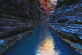 Hancock Gorge | |
 Karijini National Park | |
| Nearest town or city | Tom Price |
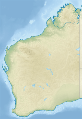
| Coordinates | 22°29′46″S 118°23′50″E / 22.49611°S 118.39722°ECoordinates: 22°29′46″S 118°23′50″E / 22.49611°S 118.39722°E |
| Established | 1969 |
| Area | 6,274.22 km2 (2,422.5 sq mi)[1] |
| Visitation | 166,000 (in 2009)[2] |
| Managing authorities | Department of Parks and Wildlife (Western Australia) |
| Website | Karijini National Park |
| See also |
List of protected areas of Western Australia |
Karijini National Park is a national park centred in the Hamersley Ranges of the Pilbara region in the northwestern section of the Australian state of Western Australia. The park is located just north of the Tropic of Capricorn, approximately 1,055 kilometres (656 mi) from the state's capital city, Perth. Formerly known as Hamersley Range National Park, the park was officially renamed in 1991.[3]
At 627,422 hectares (1,550,390 acres), Karijini is the second largest national park in Western Australia with Karlamilyi National Park being the largest park.
The park is physically split into a northern and a southern half by a corridor containing the Hamersley & Robe River railway and the Marandoo iron ore mine.[4]
The park is served by the Solomon Airport, located 15 kilometres (9.3 mi) westwards.
History
A party led by explorer F.T. Gregory explored the area in 1861. He named the Hamersley Range, on which the park is centred, after his friend Edward Hamersley.
Climate
The park is located in the Pilbara region, and is mostly tropical semi-arid climate. In summer, thunderstorms and cyclones are common, bringing 250–350 mm of rain annually.[5] Temperatures on summer days frequently exceed 40 degrees Celsius, while winter nights can bring frost.
Geology
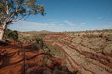
Several gorges that flow north out of the park—including Dales, Kalamina, Wittenoom and Yampire Gorges—provide spectacular displays of the rock layers:[6][7]
- Banded iron formation (BIF) - Brockman iron formation [8][9]
- Dolomite - Wittenoom dolomite [10][11]
- Shale - Mount McRae Shale [12][13]
Features

The park is most notable for its many gorges containing slot canyons, waterfalls and water holes with visitors sometimes swimming in the cold pools of water.[14]
Hamersley Gorge is located in the northwestern region of the park, while Range Gorge is in the north, Munjina Gorge is in the east, and Hancock, Joffre, Knox, Red and Weano Gorges converge in the park's center.[15]
While the park is fully open to the public, visitors are warned to exercise due caution when walking in and around the vicinity of Yampire and Wittenoom Gorges near the northern boundary of the park due to the presence of blue asbestos—a known cancer-causing agent when inhaled—which occurs in a number of the rock formations.[1]
Fauna
The park's wildlife includes red kangaroos, euros, wallaroos, echidnas, geckos, goannas, bats, legless lizards and a large variety of birds and snakes, including pythons.[16]
See also
References
- 1 2 "Australia's North West › Pilbara › Karijini National Park › Welcome (tab)". Explore Parks WA. Department of Parks and Wildlife. 2013. Archived from the original on 2016-11-04. Retrieved 2016-11-04.
- ↑ ABC: Karijini National Park visitor numbers drop, 13 October 2010
- ↑ Department of Conservation and Land Management; National Parks and Nature Conservation Authority (1999). "Karijini National Park Management Plan No. 40" (PDF). Government of Western Australia. p. 1. Archived (PDF) from the original on 12 March 2011. Retrieved 25 June 2014.
- ↑ Australia Road and 4WD Atlas, publisher: HEMA maps, published: 2007, page: 86-87
- ↑ M. Bright, 1001 Natural Wonders You Must See Before You Die, Quintet Publishing, London 2005
- ↑ Thorne, Alan (2003) Geology of the Gorges DEC
- ↑ MacLeod, W. N. (1966) The geology and iron deposits of the Hamersley Range area. Bulletin (Geological Survey of Western Australia), No. 117,http://henrietta.liswa.wa.gov.au/record=b2251313~S2 -
- ↑ http://www.riotintoironore.com/ENG/operations/497_geology.asp
- ↑ http://www.portergeo.com.au/tours/iron2002/iron2002depm1.asp
- ↑ http://dbforms.ga.gov.au/pls/www/geodx.strat_units.sch_full?wher=stratno=20327
- ↑ http://www.fish.wa.gov.au/docs/pub/AquaGroundWater/pilbara.php?9999
- ↑ http://www.physorg.com/news110122626.html
- ↑ http://www.springerlink.com/content/12va3dery2y50auu/
- ↑ "Karijini National Park". westernaustralia.com. Archived from the original on 8 September 2006. Retrieved 19 December 2006.
- ↑ "Karijini National Park Visitor guide" (PDF). Explore Parks WA (note: PDF file link appears in "Downloads & Resources" tab of webpage: parks.dpaw.wa.gov.au/park/karijini). Department of Parks and Wildlife. 2016. Archived (PDF) from the original on 2016-11-04. Retrieved 2016-11-04.
- ↑ "Karijini National Park - Beyond The 26th". ABC. Archived from the original on 24 November 2007. Retrieved 19 December 2006.
Further reading
- Padgett, Allan (1991) Karijini National Park - description of some of the more remote gorges. Landscope, Vol. 7, no. 1 (Spring 1991), pp. 16–21
External links
![]() Media related to Karijini National Park at Wikimedia Commons
Media related to Karijini National Park at Wikimedia Commons