Kafr Qaddum
| Kafr Qaddum | |
|---|---|
| Other transcription(s) | |
| • Arabic | كفر قدوم |
| • Also spelled |
Kafar Qaddum, Kefr Kaddum[1] (official) Kafr Kadum (unofficial) |
|
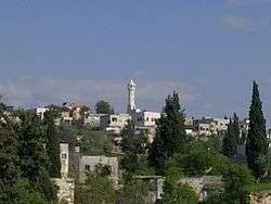
General view of Kafr Qaddum | |
 Kafr Qaddum Location of Kafr Qaddum within the Palestinian territories | |
| Coordinates: 32°13′18″N 35°08′34″E / 32.22167°N 35.14278°ECoordinates: 32°13′18″N 35°08′34″E / 32.22167°N 35.14278°E | |
| Palestine grid | 163/180 |
| Governorate | Qalqilya |
| Government | |
| • Type | Village council |
| Area | |
| • Jurisdiction | 18,943 dunams (18.9 km2 or 7.3 sq mi) |
| Population (2006) | |
| • Jurisdiction | 4,500 |
| Name meaning | "The village of Kaddum"[2] |
Kafr Qaddum (Arabic: كفر قدّوم) is a Palestinian town in the northern West Bank, located 13 kilometers west of Nablus and 17 kilometers east of Qalqilya in the Qalqilya Governorate. Surrounding towns include Jit to the east and Hajjah to the south. According to the Palestinian Central Bureau of Statistics (PCBS), the town had a population of approximately 3,500 inhabitants in mid-year 2006.[3]
Kafr Qaddum's total land area consists of nearly 19,000 dunams (about 8,000 under Palestinian civil administration and 11,000 under complete Israeli control).[4] Its built-up area consists of 529 dunams. Olive groves make up 80% of the remaining land, 15% is used for vegetation purposes, and 5% are planted crops.[5]
Prior to the Second Intifada, about 50% of the Kafr Qaddum's economy depended on work in Israel as the primary source of income, 20% depended on agriculture and animal raising, while 30% depended on jobs in private and public sectors. After 2002, over 75% of the population became jobless as business became the only other alternative for income generation. Emigration has registered a record level during the past two years, ranging between 10-15% of the total population.[5]
Since 2003, the road between Kafr Qaddum and Nablus is blocked thus elongating the travel distance by 14 km. Since July 2011, weekly demonstrations have been held in a demand to re-open the road.
History
Ottoman era
Kafr Qaddum appeared in 1596 Ottoman tax registers as being in the Nahiya of Jabal Qubal of the Liwa of Nablus. It had a population of 19 households and 2 bachelors, all Muslim. The villagers paid taxes on wheat, barley, summercrops, olives, and goats or beehives, and a press for olives or grapes.[6]
In 1858, it was by noted Biblical scholar Edward Robinson on his travels in the region,[1] and in the 1882 "Survey of Western Palestine", the village (called Kefr Kaddum) was described as "A good-sized village on low ground, with wells and olives; it has a watch-tower on the side of the chalk hill rising over it on the east, and is supplied by wells; the houses are of stone."[7]
British Mandate period
In a census conducted in 1922 by the British Mandate authorities, Kufr Qaddum had a population of 874 inhabitants, all Muslims,[8] increasing in the 1931 census, when Kafr Qaddum had 234 occupied houses and a population of 963, again all Muslim.[9]
In 1945, the population was 1,240, all Arabs, with 18,931 dunams of land, according to an official land and population survey.[10] Of this, 2,945 dunams were for plantations or irrigated land, 7,184 for cereals,[11] while 69 dunams were built-up land.[12]
1948-1967
In the wake of the 1948 Arab–Israeli War, and after the 1949 Armistice Agreements, Kafr Qaddum came under Jordanian rule.
1967-present

After the Six-Day War in 1967, Kafr Qaddum has been under Israeli occupation.
Land issues
In the Mitzpe Yishai neighborhood of the illegal Israeli settlement Kedumim, there are issues that the Israelis have improperly taken control of private Palestinian land. The Israeli Civil Administration calls it "theft", though it occurred in an "orderly manner", but without any official authorization.[13]
Main entrance
In 2003, the Israeli military closed the main entrance of the village that connects it to Nablus with a permanent roadblock, in addition, a dirt mound was put one kilometer before the roadblock, isolating one family house which made it unreachable by vehicles. In 2010, after waiting for five years for an Israeli court decision, it was ruled that the roadblock is illegal, but the court also stated that the road is "too dangerous to travel" so the Israeli forces used it as an excuse to keep it blocked.
The roadblock makes it difficult for people to reach their farmlands because they are prohibited from driving, so they must walk on foot and carry their equipment and harvest. It also delays the fifteen minute journey to Nablus to forty minutes.[14][15]
Events
- In 2012, an Israeli soldier was under investigation for the theft of a large sum of money and gold from during a raid against a resident of Kafr Qaddum.[16]
- On 2 January 2014, 85-year-old Saeed Jaser Alim became the "first Palestinian casualty of conflict with Israel in 2014; he died following a clash with Israeli soldiers at Kafr Qaddum near Nablus". Villagers say Israeli soldiers fired teargas canisters at them, one of which entered his home, and he subsequently died.[17]
References
- 1 2 Robinson and Smith, 1856, p. 134
- ↑ from "front", or "eastern" according to: Palmer, 1881, 183
- ↑ Projected Mid -Year Population for Qalqiliya Governorate by Locality 2004- 2006 Palestinian Central Bureau of Statistics
- ↑ New Israeli military road on lands of Kafr Qaddum village Applied Research Institute - Jerusalem 2007-05-11
- 1 2 Closing of agricultural roads in Kafr Qaddum village Land Research Center 2007-02-07
- ↑ Hütteroth and Abdulfattah, 1977, p. 133.
- ↑ Conder and Kitchener, 1882, SWP II, p. 163
- ↑ Barron, 1923, Table IX, Sub-district of Nablus, p. 24
- ↑ Mills, 1932, p. 63
- ↑ Government of Palestine, Department of Statistics. Village Statistics, April, 1945. Quoted in Hadawi, 1970, p. 60
- ↑ Government of Palestine, Department of Statistics. Village Statistics, April, 1945. Quoted in Hadawi, 1970, p. 106
- ↑ Government of Palestine, Department of Statistics. Village Statistics, April, 1945. Quoted in Hadawi, 1970, p. 156
- ↑ Ha'aretz 17 March 2008 Court case reveals how settlers illegally grab West Bank lands By Meron Rapoport Zeev Mushinsky, the "land coordinator" at the Kedumim local council, testified as to how it works: Council employees, Mushinsky in this case, would map the "abandoned lands" around the settlements, even if they were outside the council's jurisdiction, with the aim of taking them over. The council would "allocate" the lands to settlers, who would sign an official form stating that they have no ownership claim on them, and that the council is entitled to evict them whenever it sees fit, in return for compensating them solely for their investment in cultivating the land. Kedumim's former security chief, Michael Bar-Neder, testified that the land "allocation" was followed by an effort to expand the settlement. Bar-Neder said that once the settlers seized the lands, an application would be made to the military commander to declare them state-owned, since under the law covering the West Bank, anyone who does not cultivate his land for three years forfeits ownership of it.
- ↑ "Israeli forces rebuild roadblock in Kafr Qaddum". International Solidarity Movement. Retrieved 2016-06-03.
- ↑ "Kufr Qaddum: Protests against road closure continue despite several activists detained". www.palestinemonitor.org. Retrieved 2016-06-03.
- ↑ IDF soldiers suspected of stealing Palestinian's gold in West Bank raid, Apr. 11, 2012, Haaretz
- ↑ Palestinian, 85, dies 'after inhaling Israeli teargas', 2 January 2014, The Guardian
Bibliography
| Wikimedia Commons has media related to Kafr Qaddum. |
- Barron, J. B., ed. (1923). Palestine: Report and General Abstracts of the Census of 1922. Government of Palestine.
- Conder, Claude Reignier; Kitchener, H. H. (1882). The Survey of Western Palestine: Memoirs of the Topography, Orography, Hydrography, and Archaeology. 2. London: Committee of the Palestine Exploration Fund.
- Hadawi, Sami (1970). Village Statistics of 1945: A Classification of Land and Area ownership in Palestine. Palestine Liberation Organization Research Center.
- Hütteroth, Wolf-Dieter; Abdulfattah, Kamal (1977). Historical Geography of Palestine, Transjordan and Southern Syria in the Late 16th Century. Erlanger Geographische Arbeiten, Sonderband 5. Erlangen, Germany: Vorstand der Fränkischen Geographischen Gesellschaft. ISBN 3-920405-41-2.
- Mills, E., ed. (1932). Census of Palestine 1931. Population of Villages, Towns and Administrative Areas. Jerusalem: Government of Palestine.
- Palmer, E. H. (1881). The Survey of Western Palestine: Arabic and English Name Lists Collected During the Survey by Lieutenants Conder and Kitchener, R. E. Transliterated and Explained by E.H. Palmer. Committee of the Palestine Exploration Fund.
- Robinson, Edward; Smith, Eli (1856). Later Biblical Researches in Palestine and adjacent regions: A Journal of Travels in the year 1852. London: John Murray.
External links
- Kufr Qaddoum
- Kuffer Qaddum
- Welcome To Kafr Qaddum
- Survey of Western Palestine, Map 11: IAA, Wikimedia commons
- KAfr Qaddum Village (Fact Sheet), ARIJ
- Kafr Qaddum Village Profile, ARIJ
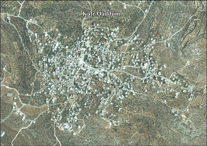
- Kafr Qaddum, aerial photo, ARIJ
- Development Priorities and Needs in Kafr Qaddum, ARIJ
- Violations during the olive picking season are continuing 21, October, 2009, ARIJ
- Several injured in Friday West Bank demonstrations, Mar.16, 2012 Haaretz
- IDF using dogs to police anti-fence protests in West Bank Officer from Oketz canine unit let his dog loose on protesters in Kfar Kadum, near Nablus, Mar.19, 2012, Haaretz
| Cities |  | |
|---|---|---|
| Municipalities |
| |
| Villages |
| |