Azzun
| Azzun | |
|---|---|
| Other transcription(s) | |
| • Arabic | عزّون |
| • Also spelled |
'Azzoun (official) Azon (unofficial) |
|
Azzun | |
 Map of path of the separation barrier around the Qalqilya and Hableh-Ras Atiya enclaves and the proposed path around Azzun | |
 Azzun Location of Azzun within the Palestinian territories | |
| Coordinates: 32°10′35.34″N 35°03′34.43″E / 32.1764833°N 35.0595639°ECoordinates: 32°10′35.34″N 35°03′34.43″E / 32.1764833°N 35.0595639°E | |
| Palestine grid | 155/175 |
| Governorate | Qalqilya |
| Government | |
| • Type | Municipality |
| • Head of Municipality | Ahmed Abdullah Umran Shanarah |
| Area | |
| • Jurisdiction | 9,130 dunams (9.1 km2 or 3.5 sq mi) |
| Population (2006) | |
| • Jurisdiction | 8,300 |
| Name meaning | Azzun, personal name[1] |

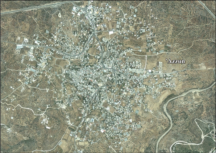
Azzun or (also spelled Azzoun (عزّون which comes from the root word "عز" (transliteration: ′Izz which means honor or esteem) is a Palestinian town in Qalqilya Governorate in the northern West Bank, located 9 kilometers east of Qalqilya and 24 kilometers south of Tulkarm. According to the Palestinian Central Bureau of Statistics census, Azzun, together with the adjacent villages of Islah and Izbat al-Tabib, had a population of over 8,900 in 2007.[2] The vast majority of the inhabitants are Muslim, with a very small Christian minority.[3][4]
History
Ottoman era
Just north of the village six -seven dry stone towers were examined in 1873. The best-preserved had six courses standing, and part of the roof. The locals stated that they were ancient vineyard towers.[5]
Azzun was a site of battle - part of Napoleon Bonaparte's campaign in Ottoman Syria. An Arab poet, Ibrahim Touqan was quoted as saying, "by means of Azzun, how soaked [in] the blood [of] Franks [in the] mother valley."[6]
When the French army marched into Palestine under the command of Napoleon in February 1799, it faced powerful and unexpected resistance from the inhabitants of Jabal Nablus under the command of their local leaders. They attacked the French army while it was marching towards Acre, especially near the valley of Azzun, taking part in the battle of Tal-Tabur. The participation of the inhabitants and local leaders of Nablus in the struggle against Napoleon reflects a territorial sense in resistance to a foreign army. Ihsan al-Nimr wrote in this regard that “the truth is that [Bonaparte’s] morale was weakened around Jabal Nablus, in the valley of Azzun, Qaqun, and al-Marj … he headed for Acre with disappointment and without determination” (al-Nimr 1961, p. 223-224). They fought for their homeland and interests. Sheikh Yussuf Jarrar wrote a poem asking the inhabitants, especially the prominent families of Jabal Nablus, to march towards Acre in order to fight the French. (Al-Nimr 1961, p. 210-211). In Doumani’s words, the poet exposes “the cohesiveness of this reign’s social formation and the shared sense of identity among its inhabitants versus the factionalism of multiple territorially based centers of power … The most striking aspect of this poem is what it does not say. Not once in its twenty-one verses does it mention Ottoman rule, much less the need to protect the empire or the glory and honor of serving the sultan”[7][8] Pierre Jacotin called the village Hazoun on his map in 1799 from the same campaign.[9]
In 1852 the American scholar Edward Robinson visited the village, which he described as having 290 males, all Muslim except for one family of Christians.[10] In 1882, the Palestine Exploration Fund's Survey of Western Palestine described Azzun as a "small village lying low on the hill-side, with several wells and olives on every side."[11]
British Mandate era
In the 1922 census of Palestine conducted by the British Mandate authorities, Azzun had a population of 700; 691 Muslims and 9 Christians,[12] increasing in the 1931 census to 994; 980 Muslim and 14 Christians, in a total of 218 houses.[13]
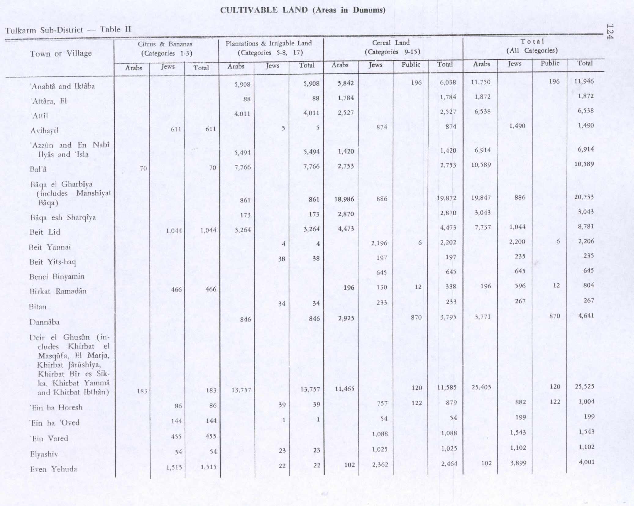
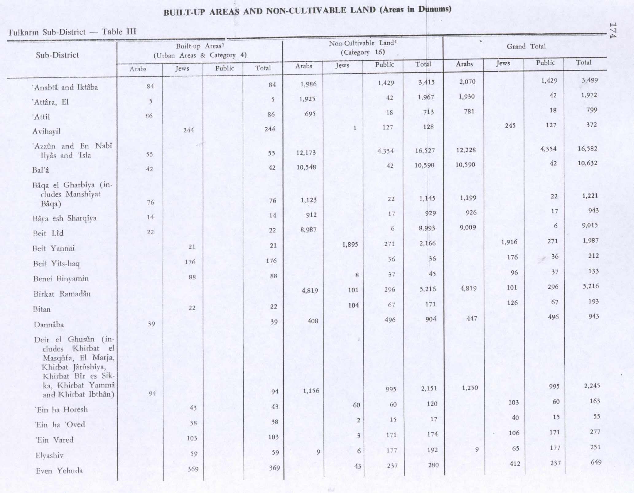
In 1945 the population of Azzun, together with Nabi Ilyas and Islah, was 1,190; 1,170 Muslims and 20 Christians,[14] who owned 23,496 dunams of land according to an official land and population survey.[15] Of this, 5,494 dunams were for plantations and irrigable land, 1,420 were used for cereals,[16] while 55 dunams were built-up (urban) land.[17]
1948-1967
After the 1948 Arab-Israeli War, Azzun was under Jordanian rule.
1967 and aftermath
After the Six-Day War, Azzun has been under Israeli occupation. In 1996 a municipal council was established to administer Azzun's civil affairs. The council has eleven members appointed by the Palestinian government. In 2012, the villages of Islah and Izbat al-Tabib were merged into the municipality of Azzun upon a decree of the Palestinian Ministry of Local Government.[18]
In 2008, the town's unemployment rate was 19%.[19] In 2012, it had increased sharply to 39%.[18]
Today, the town consists of 9,130 dunams of which 1,209 dunams is built-up area. There are four mosques located in the town. Most of the population works in agriculture and herding (40%) or trade and handicrafts (41%), while the 19% work in public sectors.[19]
The major families of Azzun are the ‘Adwan, Badwan, Radwan, Salim, Hussein, Sweidan, Zamari (or Zummary), Abu Hanniya, Odah, Hawashah, Tabib, Suleiman, Radi, Mas’ud and Abu Dayyah.
References
- ↑ Palmer, 1881, p. 183
- ↑ "Population, Housing and Establishment Census 2007 : Census Final Results in The West Bank Summary (Population and Housing)." (PDF). Palestinian Central Bureau of Statistics. 2008. Retrieved 2010-06-16.
- ↑ 2007 Census - Qalqilya Governorate Palestinian Central Bureau of Statistics, p.51
- ↑ Independent Candidate Afaf Shatara and the Palestinian Local Elections
- ↑ Conder and Kitchener, 1882, p. 171
- ↑ Azzun Past and Present Abdul Aziz Arar.
- ↑ Doumani, 1995, pp. 16-17
- ↑ Revues.org
- ↑ Karmon, 1960, p. 170
- ↑ Robinson and Smith, 1856, pp.135-136
- ↑ Conder and Kitchener, 1882, SWP II, p. 164
- ↑ Barron, 1923, Table IX, Sub-district of Tulkarem, p. 28
- ↑ Mills, 1932, p. 53
- ↑ Department of Statistics, 1945, p. 20
- ↑ Government of Palestine, Department of Statistics. Village Statistics, April, 1945. Quoted in Hadawi, 1970, p. 74
- ↑ Government of Palestine, Department of Statistics. Village Statistics, April, 1945. Quoted in Hadawi, 1970, p. 124
- ↑ Government of Palestine, Department of Statistics. Village Statistics, April, 1945. Quoted in Hadawi, 1970, p. 174
- 1 2 ‘Azzun Town Profile (including ‘Isla & ‘Izbat at Tabib Localities). Applied Research Institute-Jerusalem (ARIJ). 2013.
- 1 2 Israeli Occupation Forces closes the Northern Entrance of the Azzun Al Shamaliyya town Archived February 14, 2012, at the Wayback Machine. Land Research Center 2008-02-20
Bibliography
| Wikimedia Commons has media related to Azzoun. |
- Barron, J. B., ed. (1923). Palestine: Report and General Abstracts of the Census of 1922. Government of Palestine.
- Conder, Claude Reignier; Kitchener, Herbert H. (1882). The Survey of Western Palestine: Memoirs of the Topography, Orography, Hydrography, and Archaeology. 2. London: Committee of the Palestine Exploration Fund.
- Department of Statistics (1945). Village Statistics, April, 1945. Government of Palestine.
- Doumani, Beshara (1995). Rediscovering Palestine, Merchants and Peasants in Jabal Nablus, 1700–1900. University of California Press.
- Hadawi, Sami (1970). Village Statistics of 1945: A Classification of Land and Area ownership in Palestine. Palestine Liberation Organization Research Centre.
- Hütteroth, Wolf-Dieter; Abdulfattah, Kamal (1977). Historical Geography of Palestine, Transjordan and Southern Syria in the Late 16th Century. Erlanger Geographische Arbeiten, Sonderband 5. Erlangen, Germany: Vorstand der Fränkischen Geographischen Gesellschaft. ISBN 3-920405-41-2.
- Karmon, Y. (1960). "An Analysis of Jacotin's Map of Palestine" (PDF). Israel Exploration Journal. 10 (3,4): 155–173; 244–253.
- Mills, E., ed. (1932). Census of Palestine 1931. Population of Villages, Towns and Administrative Areas (PDF). Jerusalem: Government of Palestine.
- Palmer, E. H. (1881). The Survey of Western Palestine: Arabic and English Name Lists Collected During the Survey by Lieutenants Conder and Kitchener, R. E. Transliterated and Explained by E.H. Palmer. Committee of the Palestine Exploration Fund.
- Robinson, Edward; Smith, Eli (1856). Later Biblical Researches in Palestine and adjacent regions: A Journal of Travels in the year 1852. London: John Murray.
External links
- Welcome To 'Azzun
- Survey of Western Palestine, Map 11: IAA, Wikimedia commons
- 'Azzun (Fact Sheet), ARIJ
- Azzun (aerial photo), ARIJ
- Development Priorities and Needs in ‘Azzun (including ‘Isla & ‘Izbat at Tabib Localities), ARIJ
| Cities |  | |
|---|---|---|
| Municipalities |
| |
| Villages |
| |