Immatain
| Immatain | |
|---|---|
| Other transcription(s) | |
| • Arabic | إماتين |
|
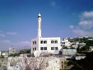
Viewpoint of Immatain | |
 Immatain Location of Immatain within the Palestinian territories | |
| Coordinates: 32°11′31″N 35°09′27″E / 32.19194°N 35.15750°ECoordinates: 32°11′31″N 35°09′27″E / 32.19194°N 35.15750°E | |
| Palestine grid | 165/177 |
| Governorate | Qalqilya |
| Founded | 1250 (estimate) |
| Government | |
| • Type | Village council |
| • Head of Municipality | Haythem Sameer Sawan |
| Area | |
| • Jurisdiction | 10,000 dunams (10.0 km2 or 3.9 sq mi) |
| Population (2006) | |
| • Jurisdiction | 2,450 |
| Name meaning | Amatin p.n.,[1] Ferata, p.n.[2] |

Immatain (Arabic: إماتين) is a Palestinian village located in the Qalqilya Governorate in the northwestern West Bank, about seventeen kilometers southwest of Nablus. The current mayor of Immatain is Haythem Sawan.
Population
According to the Palestinian Central Bureau of Statistics, Immatain had a population of approximately 2,450 inhabitants in mid-year 2006.[3] Almost double the amount live abroad for political and economical reasons. Each year, on average two family units immigrate from Immatain. Immatain has four families. They are Sawan, Ghanim, Albaree, and Matanee.
| Family name | Population est. | Percent of the population |
|---|---|---|
| Sawan | 1220 | 49.8% |
| Ghanim | 850 | 34.7% |
| Albaree | 255 | 10.4% |
| Matanee | 125 | 5.1% |
Population growth (1922 - 2007)

Geography
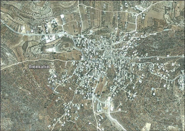
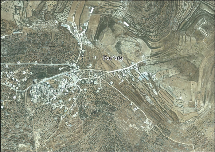
The village's lands are mostly filled with olive trees, forests, and blooming vegetation and is a prime farming location. Immatain relies on agriculture and support from descendants who reside abroad. The nearest locality is the village of Fara'ata, which is about one kilometer away. Immatain and the surrounding villages make Amra Area. These villages are Fara'ata, Jit, Kafr Qaddum, Baqat al-Hatab, Hajja, Jinsafut and al-Fanduq.
Land ownership
The following is a breakdown of land ownership.[4]
| Ethnic group | Land ownership (dunams) | Land ownership (%) |
|---|---|---|
| Arab | 7,152 | 99.9% |
| Jewish | 0 | 0% |
| Christian | 0 | 0% |
| Public | 3 | 0.0004% |
Land usage
The following is a breakdown of the land usage during 1945 in the dunams.[4]
| Land usage type | Arab dunams | Percentage |
|---|---|---|
| Irrigated and plantation | 967 | 8% |
| Area planted with olives | 1,042 | 9% |
| Area planted with cereal | 3,067 | 25% |
| Built-up | 32 | 0.3% |
| Cultivable | 4,034 | 33% |
| Non-cultivable | 3,089 | 24.7% |
| Total | 12,240 | 100% |
History
Byzantine ceramics have been found in the village.[5]
Ottoman era
Immatain and Fara'ata were incorporated into the Ottoman Empire in 1517 with all of Palestine, and in 1596 Immatain appeared in the tax registers as Matin, being in the Nahiya of Jabal Qubal of the Liwa of Nablus. It had a population of 20 households and 1 bachelor, all Muslim. The villagers paid taxes on wheat, barley, summer crops, olives, goats and beehives.[6]
In 1870 the French explorer Victor Guérin visited Fara'ata (now included in Immatain), which he described having "a very small number" of people, with some cisterns and remains of a stone sarcophagus as remnants of former history.[7]
In Palestine Exploration Fund's Survey of Western Palestine (1882), Immatain was described as "a village of moderates size on the slope of the hill, with a few olives."[8] Fara'ata was described as a "small village of ancient appearance, standing on a [..] mound, with a rock-cut tomb to the south, and a sacred Mukam to the east." Fara'ata was noted in the Samaritan Chronicle (from the 12th century) under the name of Ophrah, while it has been known under its present name since the 14th century.[9]
British Mandate era
In the 1922 census of Palestine conducted by the British Mandate authorities, Immatain (called "Ammatain") had a population of 234, while Far'ata had a population of 36, both places all Muslim.[10] In the 1931 census Immatin had 67 occupied houses and a population of 334,[11] while Far'ata had a population of 47, in a total of 11 houses. Again, both places were all Muslim.[12]
In 1945 the population of Immatin was 440, all Muslims,[13] while the total land area was 7,155 dunams, according to an official land and population survey.[14] Of this, 967 were allocated for plantations and irrigable land, 3,067 for cereals,[15] while 32 dunams were classified as built-up areas.[16] At the same time the population of Far'ata was 70 Muslims,[13] while the total land area was 1,664 dunams, according to an official land and population survey.[17] Of this, 56 were allocated for plantations and irrigable land, 961 for cereals,[15] while 10 dunams were classified as built-up areas.[16]
1948-1967
In the wake of the 1948 Arab–Israeli War, and after the 1949 Armistice Agreements, Immatain came under Jordanian rule.
Post-1967
After the Six-Day War in 1967, Immatain has been under Israeli occupation.
Immatain has more than 20 mostly small businesses. Most of the residents work in agriculture, while others work as retailers or laborers. Its main source of revenue is olive oil production.
In 2010, Far'ata was described by Gideon Levy as one of the Palestinian villages where the people "live in terror of the settlers and their accursed 'Price tag,' and nobody came to their defense".[18]
Footnotes
- ↑ Palmer, 1881, p. 178
- ↑ Palmer, 1881, p. 182
- ↑ Projected Mid -Year Population for Qalqilya Governorate by Locality 2004- 2006 Palestinian Central Bureau of Statistics.
- 1 2 3 "Immatin - اماتين -Nablus - Palestine Remembered". www.palestineremembered.com. Retrieved 2016-02-01.
- ↑ Dauphin, 1998, p. 800
- ↑ Hütteroth and Abdulfattah, 1977, p. 136
- ↑ Guérin, 1875, pp. 179 -180, cited in Conder and Kitchener, 1882, SWP II, p. 185
- ↑ Conder and Kitchener, 1882, SWP II, p. 162
- ↑ Conder and Kitchener, 1882, SWP II, pp. 162-163
- ↑ Barron, 1923, Table IX, Sub-district of Nablus, p. 25
- ↑ Mills, 1932, p. 62
- ↑ Mills, 1932, p. 61
- 1 2 Department of Statistics, 1945, p. 18
- ↑ Government of Palestine, Department of Statistics. Village Statistics, April, 1945. Quoted in Hadawi, 1970, p. 60
- 1 2 Government of Palestine, Department of Statistics. Village Statistics, April, 1945. Quoted in Hadawi, 1970, p. 106
- 1 2 Government of Palestine, Department of Statistics. Village Statistics, April, 1945. Quoted in Hadawi, 1970, p. 156
- ↑ Government of Palestine, Department of Statistics. Village Statistics, April, 1945. Quoted in Hadawi, 1970, p. 59
- ↑ Twilight Zone / The mountain that was as a monster, Gideon Levy, May 20, 2010, Haaretz
Bibliography
- Barron, J. B., ed. (1923). Palestine: Report and General Abstracts of the Census of 1922. Government of Palestine.
- Conder, Claude Reignier; Kitchener, H. H. (1882). The Survey of Western Palestine: Memoirs of the Topography, Orography, Hydrography, and Archaeology. 2. London: Committee of the Palestine Exploration Fund.
- Dauphin, Claudine (1998). La Palestine byzantine, Peuplement et Populations. BAR International Series 726 (in French). III : Catalogue. Oxford: Archeopress. ISBN 0-860549-05-4.
- Department of Statistics (1945). Village Statistics, April, 1945. Government of Palestine.
- Guérin, Victor (1875). Description Géographique Historique et Archéologique de la Palestine (in French). 2: Samarie, pt. 2. Paris: L'Imprimerie Nationale.
- Hadawi, Sami (1970). Village Statistics of 1945: A Classification of Land and Area ownership in Palestine. Palestine Liberation Organization Research Center.
- Hütteroth, Wolf-Dieter; Abdulfattah, Kamal (1977). Historical Geography of Palestine, Transjordan and Southern Syria in the Late 16th Century. Erlanger Geographische Arbeiten, Sonderband 5. Erlangen, Germany: Vorstand der Fränkischen Geographischen Gesellschaft. ISBN 3-920405-41-2.
- Mills, E., ed. (1932). Census of Palestine 1931. Population of Villages, Towns and Administrative Areas (PDF). Jerusalem: Government of Palestine.
- Palmer, E. H. (1881). The Survey of Western Palestine: Arabic and English Name Lists Collected During the Survey by Lieutenants Conder and Kitchener, R. E. Transliterated and Explained by E.H. Palmer. Committee of the Palestine Exploration Fund.
External links
- Welcome To Immatin
- Welcome To Far'ata
- Survey of Western Palestine, Map 11: IAA, Wikimedia commons
- Immatin Village (including Far’ata Locality) (Fact Sheet), ARIJ
- Immatin Village Profile (including Far’ata Locality), ARIJ
- Immatin, aerial photo, ARIJ
- Far’ata, aerial photo, ARIJ
- Israeli Hoax of Barriers removal 22,June,2004
- ew Palestinian Enclaves created by the Israeli updated wall map around Ariel Settlement Bloc. 14, June, 2006
- Testimony: Settlers attack Palestinian farmers on their land, Jan. '09, B'Tselem
- Gilad Zoher colony: a source of continuous aggression against Palestinian farmers, 20, May, 2009
- Harvest under Fire, This week in Palestine
| Cities |  | |
|---|---|---|
| Municipalities |
| |
| Villages |
| |