Jurong
| Jurong | ||||||||||
|---|---|---|---|---|---|---|---|---|---|---|
| Other transcription(s) | ||||||||||
| • Chinese | 裕 廊 | |||||||||
| • Pinyin | Yù Láng | |||||||||
| • Malay | Jurong | |||||||||
| • Tamil | ஜூரோங் | |||||||||
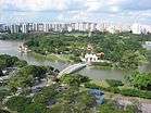
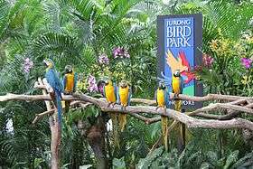
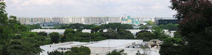
From top left to right: Flats along Jurong East, Chinese Garden and Jurong Lake, The Malaysia–Singapore Second Link as viewed from Tuas, Soon Lee Bus Park with Jurong Industrial Estate in the background, Lakeside MRT Station, Jurong Hill, Jurong Port, Jurong Bird Park | ||||||||||
 Jurong Location of Jurong within Singapore | ||||||||||
| Coordinates: SG 1°20′56.24″N 103°43′9.71″E / 1.3489556°N 103.7193639°E | ||||||||||
| Country |
| |||||||||
| Region | West Region | |||||||||
| Mainland composition |
Corresponding PAs
| |||||||||
| Offshore islands |
3
| |||||||||
| CDC | ||||||||||
| Town councils |
| |||||||||
| Constituencies | ||||||||||
| Demonym(s) |
Colloquial
| |||||||||
| Postal district | 22 | |||||||||
.jpg)


Jurong /dʒuːrɒŋ/ (Chinese: 裕 廊, Tamil: ஜூரோங்) is a geographical region located at the south-westernmost point of the West Region of Singapore. Although mostly vaguely defined, the region's extent roughly covers the planning areas of Jurong East, Jurong West, Boon Lay,[note 1] Pioneer and Tuas, along with Jurong Island in the Western Islands cluster and the southernmost portions of the Western Water Catchment. Should it be described at its greatest historical extent, the region can also include present-day Bukit Batok as well.[1] Jurong also covers several offshore islands as well, including Pulau Damar Laut and Pulau Samulun, both of which are located within the planning areas of Jurong East and Boon Lay respectively; along with the aforementioned Jurong Island. The coastline of the region on mainland Singapore, faces the strait of Selat Jurong, while the southernmost island of the region, Jurong Island, faces the strait of Selat Pandan.[2]
Jurong was industrialized in the early 1960s, in a response to the economic situation of post-war Singapore. The redevelopment of the region paved the way for the opening of an industrial sector in the Republic, something which was unprecedented of at the time.
Jurong, much like Queenstown and Toa Payoh, was also one of the earliest prototypes of a self-contained satellite town in Singapore. The region, however, is not the second oldest satellite town in Singapore, as the original entity of Jurong Town was dissolved in 1979 and subsequently replaced with the present new towns of Jurong East and West.[3]
Today, the rapid growth and development of Jurong has led it to become one of the most densely populated industrial areas in the city-state.
Etymology
"Jurong" took its name from Sungei Jurong, a river that still channels into Jurong Lake, the latter of which was created by damming the river itself.
Although its origins are disputed, the core definition of "Jurong", is probably derived from several meanings in Malay. The term could probably refer to the word for shark, "Jerung". It can also be derived from the word "Jurang" or a gorge. Jurong could also take its name from the word, "Penjuru", which roughly translates to, corner. Penjuru may most likely refer to the peninsula that sits between Sungei Jurong and Sungei Pandan. The native Malays named this peninsula, Tanjong Penjuru, which can be translated as Cape Corner in English. The present-day site of Tanjong Penjuru is now the subzone of Penjuru Crescent.[1]
Geography
Pre-industrial Jurong
Landscape

Although Jurong's geography was documented on a few maps and records following Singapore's founding in 1819, the area only became clearer to the British in an 1828 geographical survey of the island by Lieutenant Philip Jackson. In a map that was drawn after the survey, the lieutenant clearly describes most of Jurong's natural geography with the two rivers of Jurong, Sungei Jurong and Sungei Pandan, marked on the map. He also noted down several islands which have since ceased to exist. Such islands include, Pulau Ayer Chawan, Pulau Butun, Pulau Pese (Pulau Pesek), Pulau Sakra and Pulau Saraya (Pulau Seraya), all of which have since merged to form Jurong Island. Current geographical landmarks such as Pulau Damar Laut and the strait of Selat Sembilan (now Selat Jurong) have also been included on the map.[1]
The two rivers of Jurong were mentioned again in 1848, when a second survey conducted by John Turnbull Thomson, described the original shape and settlements of Sungei Jurong and Sungei Pandan. Turnbull describes both rivers as, "large creeks" with settlements around the both.
However, in the case of Sungei Jurong, Thomson gives his description as such:
a large creek which divides at the top into two branches, the east one being called by the Chinese the Jurong, and the west Peng Kang— John Turnbull Johnson
Before the damming of Sungei Jurong, the present-day site of Jurong Lake was once occupied by two streams that split at the junction of the river. These two streams have since ceased to exist. However, like what Thomson said, these bodies of water roughly marked the present day locations of Jurong East and West, at that time identified as Jurong and Peng Kang on colonial era maps respectively.[1]
Before its development in the 1960s, Jurong was left close to its pristine state after Singapore's founding in 1819. Although there were a few settlements around Jurong, most of the land was mainly uncharted territory. Swamps dominated the coastline of Jurong, yielding large amounts of wildlife such as mudskippers and horseshoe crabs. A forest reserve of dipterocarp trees would have once stood inland behind the grove of rhizophora trees along the coast. Low hills were mainly the highest elevated points around Jurong, although most of them were later leveled over the years.
This was evident, given the description made by Commodore Perry in his accounts of Jurong made during the Perry Expedition:
Inland, the surface of the country is diversified with low hills and shallow valleys— Matthew Calbraith Perry, Narrative of the Expedition of an American Squadron to the China Seas and Japan[4]
Territorial extent
In maps made by the British administration before Singapore's self-governance in 1959, the colonial era district of Jurong was rather small, occupying what is today the present-day town of Bukit Batok. However, as the boundaries of Jurong were never made clear by surveyors at that time, many residents have often regarded the areas along the stretch of Jurong Road as part of the region itself. Such areas include the colonial era districts of Peng Kang (now present-day Jurong West and Boon Lay), the southern portions of Choa Chu Kang (now Tengah), Pandan (now the southern parts of Jurong East and a subzone in Clementi) and Tuas (now Pioneer and the Tuas peninsula).[1][note 2]
Modern Jurong
Ecology

Today, most of what is left of the original pristine Jurong is restricted to the areas around the Pandan Reservoir and Sungei Pandan. Little traces of the dipterocarp forest still remain. The mangrove swamps today are now just a fraction of its former self, located at the mouth of Sungei Pandan. The untouched mangrove fringes still hold the last remnants of wildlife in Jurong. It is because of this that area remains a hotspot for nature enthusiasts and bird watchers to this day.[1]
Water bodies
the sea shore is low and overgrown with mangroves, and occasionally broken by the entrances of salty creeks, which, penetrating sometimes to the extent of six or seven miles, overflow their banks, and convert their neighbouring soil into marsh.— Matthew Calbraith Perry, Narrative of the Expedition of an American Squadron to the China Seas and Japan[4]
Jurong is home to two prominent rivers, Sungei Jurong and Sungei Pandan, both of which flow into two larger water bodies, Jurong Lake and Pandan Reservoir respectively. The two rivers also source from Selat Jurong, a strait that faces south of mainland Singapore and north of Jurong Island.

The two rivers also have extensions that flow into the mainland portion of the region. Sungei Pandan has a western branch, Sungei Ulu Pandan, which flows from Jurong East into the town of Clementi before cutting off at Queenstown located east of Clementi. Sungei Jurong channels out of Jurong Lake via a stream located west of the lake and Jurong Canal located directly north of the lake. The canal also serves as the boundary line between the towns of Jurong East and West.[5]
Elevation points
The highest elevation point in the region is Jurong Hill, located in the industrial area of Boon Lay just adjacent to Jurong Bird Park.[1]
Geology
Jurong's unique locale lends to itself a special rock formation unlike any other in Singapore. Named the Jurong Formation, the sedimentary rock deposits can trace its roots back to the late Triassic and early to middle Jurassic periods.
Territorial extent
The name, "Jurong", is often used to collectively describe the region's five main planning areas. However, the URA doesn't officially recognize all of these places as a single legal entity. Since the gazetting of the 1998 Master Plan, the Authority has officially classified Jurong as five individual separate planning areas.[6] When Jurong is split into these five contiguous parts, it forms Jurong East and West in the north and north-west, Boon Lay and Pioneer to the south and south-west and Tuas to the extreme west of the region. Each of these individual areas can yet be further divided into subzones, smaller subdistricts that are a part of the larger planning area itself. If all five planning areas are combined, there would be a grand total of 34 subzones in Jurong.[3][5]
The boundaries of modern-day Jurong were first demarcated in the 1960 proposal of the new town. The planned town was to be located entirely south of Jurong Road, combining land that was once the colonial era districts of Jurong, Peng Kang, Pandan and the southernmost portion of Choa Chu Kang.[1][7][note 2] As a result of this proposal, the government gazetted portions of land from these areas to increase the overall size of Jurong.[8] These boundaries were later further defined with the introduction of the URA 1991 Concept Plan in September 1991.[9][10]
History
Before Raffles (c. 1600 – 1819)
The earliest known records of Jurong can be traced back to 1595, on a maritime documentation of oriental trading routes. Titled "Reys-gheschrift van de Navigation der Portugaloysers in Orienten", the journal written by Dutch author Jan Huyghen van Linschoten, names a certain "Selat Sembilan" that one must cross eastwards after reaching the southernmost end of the Strait of Malacca.[11] This suggests that the straits near Jurong, witnessed a significant role in the ancient maritime Silk Road. Although not mapped by Linschoten, the location of Selat Sembilan was later identified in Philip Jackson's 1828 survey of Singapore. Despite land reclamation works along parts of Jurong and Tuas, Selat Sembilan still exists today as Selat Jurong, stretching along the coast of the region.[1]
Even before the arrival of Sir Stamford Raffles in 1819, small settlements had already been built along Jurong's coastal areas as well as the present-day site of Jurong Island, Pulau Damar Laut and Pulau Sembulan. Such squatters were inhabited by the native Orang laut, some of whom migrated from the nearby Dutch East Indies and Malaya.
Colonial Jurong (1819–1942)
Earliest developments
Post-colonization, Jurong had a small population of inhabitants scattered along the banks of the area's two main rivers, Sungei Jurong and Sungei Pandan. It mainly accompased of a large Chinese and Malay migrant population.
The majority of the Chinese population was Hokkien-speaking, immigrating from Anxi County in the province of Fujian, China. A Teochew demographic was also prevalent in Jurong. Originating from the City of Jieyang, the Teochew-speaking population mainly settled along the westernmost portions of Jurong.[1]
Most of the Malays and Orang laut in the area were natives of the land, settling in squatters along the coast of Jurong way before the founding of modern Singapore in 1819. There were also other Ethnic Malay groups that came down from the rest of the Malay Archipelago, migrating from parts of present-day Malaysia and Indonesia. The exact statistics of foreign Malays settling in Jurong after 1819 though, is not clear.
In a visit to the area in 1848, then Chief Surveyor of Singapore, John Turnbull Thomson, made one of the earliest accounts on human settlements in Jurong.
He described the demographics along Sungei Jurong as such:
The Chinese here are numerous and there are also several Malay villages.— John Turnbull Thomson
Thomson also gave his description on the population along Sungei Pandan:
a large creek with Chinese and Malays at the head— John Turnbull Thomson
With the increase in population size over the years, the need for a mode of travel to and from the Town of Singapore, was necessary. Between 1852 and 1853, the first few portions of Jurong Road were paved to connect villages around Jurong to the metropolitan areas of Singapore Town and the rest of the island. This first portion of Jurong Road started from the seventh milestone of Bukit Timah Road ending along the head of Sungei Jurong. Although it isn't known when the rest of the road was paved, by 1936, the road stretched up to the district of Tuas.[1]
An American visit
_by_Peter_Berhard_Wilhelm_Heine_and_Eliphalet_M_Brown.jpg)
In 1853, American Commodore, Matthew C. Perry, led an expedition in an attempt to open up Bakumatsu Japan to the world.
The fleet of the Perry Expedition, stopped over a few countries before reaching the Japanese archipelago. Amongst one of the few docking locations during the trip, was Singapore. This made it the second time that the United States had made a diplomatic presence on the island since the Exploring Expedition.
Perry's crew anchored their fleet of two frigates and two sloops-of-war along Selat Sembilan and Sungei Jurong, where they surveyed the surroundings of the strait and the river.
Wilhelm Heine and Eliphalet Brown, two of the official expedition artist, were tasked at producing a lithograph depicting the villages along Sungei Jurong. The resulting image was one of the earliest illustrations of colonial-era Jurong.
What is interesting about the image is the forest fire shown in the background. This was common at the time as such fires were often rampant throughout Jurong in the mid 19th century.[1] Another thing of note is the United States flag seen on the stern of the sampan in the foreground.[4]
Earliest industries
Agriculture
Before the early 1960s, plantations dominated the area, harvesting pineapple, pepper and nutmeg as sources of income for the district. However, the main prepotent export for Jurong, was gambier. Its practical and medicinal properties prove profitable for the Chinese kangchus, men who were into the gambier industry. In 1855, the Municipal Committee reported 20 of such legal plantations existing within Jurong. However, this figure isn't exactly accurate, given the fact that many illegal ones were also set up in the area.[1]
Rubber was also a popular industry in Jurong. Often seen as a strong competitor to the gambier businesses that were prime in the district. By the first half of the 20th century, the practices of rubber tapping overtook the role of harvesting gambier, an activity that once thrived in Jurong. A notable example of a gambier business that shifted to the rubber sector, was the plantation that belonged to Chinese business magnate, Chew Boon Lay. The large amount of land that the plantation stood on was often well associated with his name. Today, this area is known as Boon Lay Place, a small subzone that is enclaved within the new town of Jurong West.
Aside from crops, fishing was also a prominent form of income in Jurong. But this job was mostly handled by the local Malay and Orang laut population, most of whom chose to settle along the coastline of Jurong. Fishing was also conducted along the two prominent rivers of Jurong, Sungei Jurong and Sungei Pandan.
Prawns farms were also set up along these two rivers, where the crustacean species grew in large numbers. By the 1950s, 500 acres of land was specifically assigned for prawn farming in Jurong. This was roughly half the total amount of land used for prawn farms in Singapore at that time.[1]
Industrialisation (pre-war phase)
For some time before the rapid industrialisation occurring in Jurong throughout the 1960s, Jurong was already a host to a few businesses in the heavy industry, most notably, the brickwork sector. Businesses involving brickwork and earthenware were often set up around Yunnan in Jurong West, where soil conditions could yield clay and terracotta. Although some factories producing the material closed down over the years, the brickwork industry still runs in Jurong even to this day.
The earliest brick factories emerged in the 1920s, often exporting the building material to construction sites around Singapore Town. A notable brick producer in Jurong was the Jurong Brickworks. With its origins in the 1930s,[12] Jurong Brickworks was one of the largest private brick suppliers in Singapore. During its heyday in the 1970s, it manufactured over three million bricks per month. The factory was eventually shut down in 2005 and the manufacturing plant was demolished that same year.[1]
Another notable earthenware producer in Jurong is the Thow Kwang Dragon Kiln. Set up by Chinese immigrants in the 1940s, the pottery manufacturer along with its counterpart, Jalan Bahar Clay Studios, still exists today as the only surviving pair of dragon kilns in Singapore. Although traditionally a part of Jurong, the kilns are technically located next to Nanyang Technological University, which is situated in the Western Water Catchment.[1]
Other ventures
Aside from his plantation, Chew Boon Lay also owned one of the earliest factories in Jurong. During its time in operation from 1950 to 1958, the manufacturing plant produced consumable canned goods with local products ranging from kaya to curry and even peanut butter. It was located on Jalan Ahmad Ibrahim opposite the location of what is now Jurong Bird Park. The same building was also a temporary host to the offices of the Jurong Town Corporation during its inception in 1968.[1]
Second World War (1941–45)
101 Special Training School

Following the invasion of Thailand in December 1941, the Imperial Japanese Army was heading southwards down the Malay Peninsula. It was rather obvious by then, that an Axis assault on the island, was imminent. In light of the incoming threat, the Oriental Mission of the Special Operations Executive chose to set up a training institution in Singapore to assist and train resistance movements throughout Malaya.
One proposed site for the base, was Pulau Ubin. However, the suggestion was dropped for a number of reasons. Issues such as the difficulty of clearing foliage, the cost of building said institution, the lack of a freshwater source and the risk of contagious malaria, made Pulau Ubin unsuitable for the location.

The SOE eventually settled down on an isolated island known as Tanjong Balai. Located at the mouth of Sungei Jurong, the island was home to a single solitary man-made structure, a bungalow that was formerly owned by Jewish businessman, Joseph Brook David. Apart from the bungalow, the island was also well hidden amongst the canopy of a secondary rainforest and even better was the convenience of accessing the location, by boat or by a well hidden path.
With the SOE moving into the premises, the Number 101 Special Training School, was formed. It mainly trained its personnel in the fields of sabotage, reconnaissance, and espionage.
With the Japanese gaining access into Singapore by February 1942, the school was quickly dissolved. Documents were destroyed and the premises at Tanjong Balai were left abandoned. A new SOE base was later established in Burma in the city of Rangoon.
Today, the island of Tanjong Balai is relatively unheard of. Its location has since been subsumed by Jurong Port after reclamation works in the 1980s.[1]
Modern Jurong (1960-present)
The need to industrialize
Post-war Singapore was plagued with financial trouble. An uneducated population and the lack of jobs meant that the amount of manpower was scarce. By the end of the 1950s, the unemployment rate stood at 14%, an estimated 200,000 of the population at that time. To add on to the problem, the government had to cater to the high birth rate, which used to increase every year by 4%.[1]
With the Cold War looming and the threat of communism spreading from Malaya, the Legislative Assembly was being pressured to keep the crown colony financially stable.
In 1959, the People's Action Party emerged victorious in the first general election held in self-governing Singapore. High on the party's agenda was the promise of better employment and the need to build up the weak economy of a growing self-governing nation.[13]
The newly led PAP government had a desperate need to counter the issue and finance minister, Dr Goh Keng Swee, was put in charge of this task.
Goh saw that the only way to improve Singapore's weak economy was through industrialization. He envisioned an industrial town in Singapore that had modern facilities such as factories and shipyards. Although such an idea wasn't the first, Dr Goh's plans for an industrial estate in Jurong were much more ambitious than previous proposals.[1]
Jurong Industrial Estate
On July 4, 1960, the Legislative Assembly announced a proposal to construct a planned town in the Jurong region.[14] The $45.7 million project begun almost immediately after the proposal's announcement, with the planning process taking place in August that same year.[15]
For Jurong's industrialization, the United Nations Industrial Survey Mission placed Dutch advisor, Dr Albert Winsemius in charge of the project. The UN mission also deployed Frenchman, Mr P. Schereschewsky to survey Jurong's suitability for an industrial town.[15]
In 1961, the Economic and Development Board (EDB) was formed to industrialise Jurong and earthworks began that same year. In 1962, the Finance Minister Dr Goh Keng Swee, laid the foundation stone for the National Iron and Steel Mills, the first factory in the new industrial estate.[16] Many Singaporeans doubted the success of Dr Goh's plan to develop the area, giving it the name "Goh's Folly". They were quickly proven wrong as 24 factories were established in 1963. In May 1965, Jurong Port became operational.
In 1968, the Jurong Town Corporation was created to manage Jurong's development. By this time, 14.78 square kilometres of industrial land has been prepared, 153 factories were fully functioning and 46 more were being constructed. With the Singapore economy constantly expanding, finding space for new industries is an ever-present challenge. Seven islets off the coast of Jurong were merged to create the 30 square kilometre Jurong Island, which is to be the base for oil, petrochemical and chemical industries. Construction of Jurong Island began in the early 1990s and is scheduled to be completed in 2010. A number of plants began operating there in the late 1990s. A bridge, the Jurong Island Causeway, links Jurong Island to the mainland. Access to the island is restricted which may improve its security against terrorist attacks.
Townships of Jurong

The first few low-rise flats in Jurong Town emerged in the precinct of Taman Jurong between 1963 and 1964, developed by the Housing and Development Board. Around this time, other notable housing estates, such as Boon Lay Place, began breaking ground as well. Despite the new residential developments, Jurong lacked a growing population. Reasons were largely due to the location of Jurong and the lack of infrastructure around the region at the time.
The development of Jurong East and West started in the 1979 when estates such as Taman Jurong, Boon Lay Place, Bukit Batok, Bukit Gombak, Hong Kah, Teban Gardens and Yuhua were built, mostly due to the resettlement of Hong Kah and surrounding villages. Boon Lay Place, Taman Jurong and Hong Kah formed Jurong West New Town. Yuhua, Teban Gardens, Bukit Batok and Bukit Gombak formed Jurong East New Town.

In 1982, Jurong West New Town started expanding as Jurong West Extension, which saw the realignment of the PIE to make it go through the southern boundary of present-day NTU, while converting the former section into Jurong West Avenue 2 and renaming the original Upper Jurong Road into Jurong West Avenue 4. Pioneer Road was extended North wards from present-day Upper Jurong Road as Pioneer Road North to the new PIE exit, which signalled the start of the development of Jurong West Extension (Yunnan, Pioneer and Gek Poh).[17] The N9 estate was the first to be built and the N6 estate was the last, in the early 2000s. The MRT Line was extended from Lakeside to Boon Lay in 1990 and again to Pioneer in 2009.
Spyros disaster
On October 12, 1978, Greek tanker Spyros, exploded at Jurong Shipyard, killing 78 people in the immediate vicinity. The result was one of Singapore's worst man-made disasters since the Second World War and the worst industrial accident since the inception of the Republic of Singapore.
Infrastructure
Transportation
Private
Jurong is well connected to the rest of Singapore by road, with Kranji Expressway linking them to the northern part of Singapore, Pan Island Expressway linking them to the Eastern part of Singapore and the Ayer Rajah Expressway linking them to the south-eastern part of Singapore. Clementi Avenue 6 and Jurong Town Hall Road complement the 3 expressways, topping off the well-built road connection from Jurong to all parts of the island.
Mass Rapid Transit
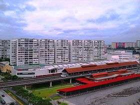
The region is well-connected to the MRT system with Jurong East and Chinese Garden serving Jurong East. Lakeside, Boon Lay and Pioneer serving Jurong West and Joo Koon serving Pioneer.
Bus
Jurong is served by public bus services originating from 2 interchanges and 1 bus depot, namely the Jurong East and Boon Lay bus interchanges and Soon Lee Bus Depot.
Economy
Commercial


The more notable shopping malls in Jurong are Jurong Point Shopping Mall in Pioneer and IMM in Yuhua.
The largest suburban mall in Singapore, Jurong Point Shopping Mall is well-accessible by bus services from all the residential precincts of Jurong except Yuhua and Teban Gardens. This mall targets young adults and families with stalls selling fashion, food and beverages, sports, entertainment and lifestyle products. It also serves the elderly population with body-wellness stores and healthcare centres located at level 4 and 5 of the mall. It is well linked to the Boon Lay MRT Station and Boon Lay Bus Interchange.
IMM is a mall located within walking distance and visible from Jurong East MRT Station. Within it, the mall contains a large family-orientated food court at the highest storey, many furniture stores and other stores that meet the needs of the people. Such examples include a Popular Bookstore, one of Singapore's largest distributors of print and stationary products and a Daiso department store, which sells decorative stuffs and other lifestyle products at a relatively low price of $2. There is a Giant Hypermarket at level 1 of the mall to suit the marketing needs of the people. A free shuttle bus service ferries visitors to the mall from the two main MRT stations that serve Jurong.
There are other shopping malls in Jurong, but are only well known within the precinct they are located in. Such malls include, 'Hong Kah Point' in Hong Kah and 'Taman Jurong Shopping Centre' in Taman Jurong.
Tourism
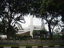
- Singapore Science Centre
- Snow City
- Singapore Discovery Centre
- Singapore Army Museum
- Jurong Bird Park (To be ceased and relocated to Mandai by 2020)
Education
Jurong Junior College is located within the region, in between Hong Kah and Boon Lay. There is at least 1 primary school and 1 secondary school in each precinct of Jurong including the Shuqun Primary School established in 1925 in Jurong West.
Politics
Jurong used to be an independent political constituency in the 1959 general elections. Chia Thye Poh represented the constituency in parliament between 1963 and 1966. Then, 'Boon Lay Constituency' was carved out in 1976 and 'Hong Kah Constituency' in 1984, forming 4 separate constituencies. 'Hong Kah Constituency' eventually became a GRC that consisted of Nanyang, Hong Kah, Gek Poh and Bukit Batok in 1988. Teban Gardens, Pioneer, Yuhua and Taman Jurong were under 'Bukit Timah Constituency' and the N9 region of Nanyang was under 'Jurong Constituency' all that while.
In 2001, there were major changes in the political constituties of Jurong. 'Boon Lay Constituency', together with Teban Gardens and Pioneer, were absorbed into the expanded West Coast GRC. 'Hong Kah Constituency' was re-designed to include towns of Chua Chu Kang (Limbang and Yew Tee) and Bukit Gombak and only Nanyang and Gek Poh remained in the constituency, this time including the N9 region of Nanyang. 'Jurong Constituency' was abolished. Hong Kah and Bukit Batok were regrouped into the newly created Jurong GRC, along with Yuhua and Taman Jurong. As such, the entire political system of Jurong was changed with 3 GRCs as a result.
10 years later, in 2011, Gek Poh, Yuhua and Pioneer were crafted out from each of the 3 GRCs to become SMCs. In total, there are now 6 constituencies in Jurong.
Nonetheless, though divided into 6 separate constituencies, all the precincts are collectively managed by the PAP and known as Jurong.
References
- 1 2 3 4 5 6 7 8 9 10 11 12 13 14 15 16 17 18 19 20 National Heritage Board. Jurong Heritage Trail. Retrieved 12 November 2015
- ↑ Singapore Department of Statistics - Planning Areas/Subzones in Singapore (Year 2015)
- 1 2 "Jurong flats: HDB takes over from JTC". The Straits Times. 2 June 1979.
- 1 2 3 Matthew Calbraith Perry (1856). Narrative of the Expedition of an American Squadron to the China Seas and Japan (PDF).
- 1 2 "URA 2014 Master Plan". Urban Redevelopment Authority. Retrieved 24 November 2015.
- ↑ "Singapore Infopedia - Development guide plan". National Library Board.
- ↑ "Singapore's undeveloped west coast will get a $45.7 m. industrial town". The Straits Times. 6 July 1960.
- ↑ "2.440 ACRES FOR JURONG NEW TOWN GAZETTED". The Straits Times. 9 July 1960.
- ↑ "URA 1991 Concept Plan". Urban Redevelopment Authority. Retrieved 7 December 2015.
- ↑ "HistorySG - 1991 Concept Plan is unveiled". National Library Board.
- ↑ Jan Huyghen van Linschoten (1595). Reys-gheschrift van de Navigation der Portugaloysers in Orienten.
- ↑ "NOTICE - JURONG BRICK WORKS". The Straits Times.
- ↑ "Singapore – Road to Independence". Library of Congress. Retrieved 27 June 2006.
- ↑ "$4.5m. INDUSTRIAL TOWN PLAN for S'PORE". The Straits Times. 4 July 1960.
- 1 2 "UN EXPERT FOR S'PORE". The Straits Times. 26 July 1960.
- ↑ "NatSteel - Our Heritage". Retrieved 6 December 2015.
- ↑ "New Jurong West to be twice as big". The Straits Times.
Notes
- ↑ The planning area of Boon Lay (located in southern Jurong) is not to be confused with the neighbourhood of Boon Lay in the town of Jurong West.
- 1 2 Colonial era districts pre-1960, do not reflect present-day boundaries that are demarcated by the URA.
Sources
- Victor R Savage; Brenda S A Yeoh (2003). Toponymics - A Study of Singapore Street Names. Eastern Universities Press. ISBN 981-210-205-1.
- National Heritage Board (2002). Singapore's 100 Historic Places. Archipelago Press. ISBN 981-4068-23-3.
External links
| Wikimedia Commons has media related to Jurong. |
Precincts of Jurong | ||
|---|---|---|
| West | ||
| East | ||
| Organisations |  | |
|---|---|---|
| Building Programmes | ||
| Upgrading Programmes |
| |
| Other | ||