Kallang
| Kallang | ||||||||
|---|---|---|---|---|---|---|---|---|
| Planning Area and HDB Town | ||||||||
| Other transcription(s) | ||||||||
| • Chinese | 加冷 | |||||||
| • Pinyin | Jiā Lěng | |||||||
| • Hokkien | Ka-léng | |||||||
| • Malay | Kallang | |||||||
| • Tamil | காலாங் | |||||||
From top left to right: Costa Rhu condominium with Benjamin Sheares Bridge and the Singapore Flyer in the background, Tanjong Rhu Suspension Bridge at night, Jalan Besar Stadium, National Stadium, Golden Mile Complex, River Vista@Kallang | ||||||||
| Country |
| |||||||
| Region |
| |||||||
| CDCs | ||||||||
| Town councils |
| |||||||
| Constituencies | ||||||||
| Government | ||||||||
| • Mayors |
Central Singapore CDC South East CDC
| |||||||
| • Members of Parliament |
Jalan Besar GRC
Mountbatten SMC Tanjong Pagar GRC | |||||||
| Area[1][2] | ||||||||
| • Total | 9.17 km2 (3.54 sq mi) | |||||||
| • Residential | 2.1 km2 (0.8 sq mi) | |||||||
| Population (2015)[1][2] | ||||||||
| • Total | 101,210 | |||||||
| • Density | 11,000/km2 (29,000/sq mi) | |||||||
| Demonym(s) |
Official
| |||||||
| Postal districts | 1, 7, 12, 13, 14, 15 | |||||||
| Dwelling units | 35,742 | |||||||
| Projected ultimate | 57,000 | |||||||


Kallang /kɑːlɑːŋ/ (Chinese: 加冷, Tamil: காலாங்) is a planning area and residential town located in the Central Region of Singapore.
Development of the town is centered around the Kallang River, which is Singapore's longest river. Kallang planning area is bounded by Toa Payoh in the north, Geylang in the east, Marine Parade in the southeast, Marina East in the south, the Downtown Core in the southwest, Rochor and Newton in the west, as well as Novena in the northwest.
Throughout its history, Kallang was home to several landmarks of Singapore. Some of which were built along the banks of the Kallang Basin, including the National Stadium as well as the country's first civilian airport, the Kallang Airport. The famous Kallang Roar and Kallang Wave could have their roots traced to the old National Stadium which hosted several National Day Parades and notable football events.
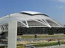
Today, Kallang is probably best known for being the location of Jalan Besar Stadium and the Singapore Sports Hub, which is home to the new National Stadium and the Singapore Indoor Stadium. The latter played host to the 2016 National Day Parade, marking the first time that a National Day Parade was held in Kallang since 2006.
Etymology
"Kallang" is an old Malay reference to the orang laut (people of the sea), called orang biduanda kallang, who lived in the vicinity of the Kallang River and Singapore River. At the time of Raffles' landing in Singapore in 1819, there were about 500 orang biduanda kallang. In 1824, the Temenggung moved the orang kallang to the Pulai River in Johor. They consisted of about 100 families, but in 1847 most of them died of a smallpox epidemic. By 1848, the orang kallang were virtually extinct.
There are other possible meanings for this particular place name. Kallang may also be a corruption of the Malay word kilang, meaning "mill" or factory". There were saw mills and rice mills here. Another explanation for the origin of Kallang is that it is derived from galang, which means "to put a boat on wooden stocks or rollers", an appropriate term as the Kallang area straddles both sides of the Kallang River.
Geography
Location
The perimeter of Kallang is made up of Toa Payoh in the north, Geylang in the east, Marine Parade in the southeast, Marina East in the south, the Downtown Core in the southwest, Rochor and Newton in the west, as well as Novena in the northwest. The Kallang planning area is part of the Central Region of Singapore.[3]

Although by definition a single planning area according to the Urban Redevelopment Authority, the Housing and Development Board (HDB) town of Kallang/Whampoa also constitutes the housing estate of Whampoa, located within the subzone of Balestier in the adjacent planning area of Novena.
Historically, the area of Kallang covered areas as far north as present-day MacPherson estate. Villages that once stood in this area included Kampung Kallang Pasir, Kampung Kallang Pokok, Kampung Kallang Laut, Kampung Kallang Batin and Kampung Kallang Rokok.[4]
The areas at the upstream of the Kallang River, including present-day MacRitchie Reservoir, Lower Pierce Reservoir (originally called Kallang River Reservoir) and their surrounding regions, were organized under the Ulu Kallang mukim.[5] "Ulu" is a Malay term which translates to rural or remote.
Subzones
| Name of estates | Location | Notable structures | Accessibility |
|---|---|---|---|
| Bendemeer | Areas around Boon Keng MRT Station, Serangoon Road, Bendemeer Road, Saint George's Road and Saint Michael's Road | Boon Keng MRT Station, Hong Wen School, Bendemeer Primary School, Bendemeer Secondary School, Northlight School, Kallang Community Club and Kallang Neighbourhood Police Post | Boon Keng MRT Station and buses |
| Geylang Bahru | Estates along Geylang Bahru and Kallang Bahru | Kallang Basin Swimming Complex, Kallang Distripark, Ministry of Manpower Service Centre, Kolam Ayer Community Club, Kolam Ayer Neighbourhood Police Post and the future Geylang Bahru MRT Station | Buses |
| Kampong Bugis | Areas along Kallang Riverside and south of Kallang Road | Lorong 1 Geylang Bus Terminal, Kallang Riverside Park, the former Kallang Gasworks, the old Kallang Airport terminal building and Merdeka Bridge | Buses |
| Tanjong Rhu | Southern Kallang; Singapore Sports Hub and areas along Tanjong Rhu Road | Dunman High School, Stadium MRT Station, Mountbatten MRT Station, Singapore Swimming Club, Singapore Sports Hub, Kallang Theatre, Leisure Park Kallang, Kallang Track, Kallang Tennis Centre, Kallang Field, Kallang Ground, Kallang Netball Centre, Kallang Squash Centre, Benjamin Sheares Bridge, Katong Community Centre and the future Tanjong Rhu MRT Station and Katong Park MRT Station | Stadium MRT Station, Mountbatten MRT Station and buses |
| Kallang Bahru | Areas along Kallang Bahru | Singapore Post Kallang Delivery Base, Aperia Mall and the future Bendemeer MRT Station | Buses |
| Crawford | Areas near to Nicoll Highway MRT Station, Republic Avenue, Crawford Street and Beach Road | Kallang Riverside Park, Golden Mile Complex, Kampong Glam Community Club, Kampong Glam Neighbourhood Police Post, Marina Promenade and The Concourse | Lavender MRT Station, Nicoll Highway MRT Station and buses |
| Lavender | Areas around Lavender MRT Station, King George's Avenue, Jalan Besar and Lavender Street | Lavender MRT Station, Jalan Besar Stadium, Jalan Besar Swimming Complex, Jalan Besar Community Centre, People's Association headquarters and Immigration and Checkpoints Authority (ICA) Building | Lavender MRT Station and buses |
| Boon Keng | Areas near Kallang MRT Station and Upper Boon Keng Road | Kallang MRT Station and Geylang West Community Club | Kallang MRT Station and buses |
| Kampong Java | Western Kallang; areas near Jalan Besar, Balestier Road, Rangoon Road, Owen Road, Dorset Road, Tessensohn Road and Cambridge Road | Little India MRT Station, Farrer Park MRT Station, Land Transport Authority headquarters, City Square Mall, KK Women's and Children's Hospital, Farrer Park Primary School and Pek Kio Community Centre | Little India MRT Station, Farrer Park MRT Station and buses |
Geology
Kallang sits on the Kallang Formation which largely consists of soft marine clay.[6] Aside from its namesake Kallang, the Kallang Formation is present in other parts of Singapore such as Marine Parade and Clementi.
The present landscape of Kallang is the result of extensive land reclamation that took place in the 1960s. Led by the Housing and Development Board, the swamps and mudflats were filled in using earth sourced from the leveled hills of Toa Payoh. Before land reclamation, Kallang was a large swamp that stretched all the way to Aljunied Road during floods.
Water bodies
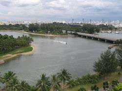
The Kallang River which meanders through the area is famous for its water sports. The source of the river is the Lower Pierce Reservoir (formerly known as the Kallang River Reservoir) and the river mouth is located at Kallang Basin, near to the Merdeka Bridge. At more than 10 kilometres, the Kallang River is the longest river in Singapore. The area is also drained by the Geylang River, Rochor River, Sungei Whampoa and the Pelton Canal. The Kallang River, together with its tributaries, drain about one-sixth of Singapore Island's land area and form part of the Marina Reservoir.
In 1977, the Singapore government embarked on a ten-year-long clean-up project for the Kallang River and the nearby Singapore River, transforming them into the clean waterways of today.[7]
The area also used to form part of Singapore's southern coastline, as evident from the location of Beach Road. Kallang River used to empty into the Singapore Straits at Kallang Basin.
Parks
The Kallang Riverside Park along the Kallang River is a riverine park managed by the National Parks Board.[8] On the side nearer to the Singapore Sports Hub, there is a beach while the opposite side nearer to Crawford Street is a pedestrian walkway. The walkway is connected to Gardens by the Bay at Marina Centre.
The Kallang Park Connector is part of the Park Connector Network managed by the National Parks Board, running from Bishan in the north to Kallang in the south. Built in 1995, it is the first park connector in Singapore. As their name imply, these connectors aim to form a continuous loop which would hopefully connect all the major parks within Singapore. Kallang Park Connector runs parallel to Kallang River, the longest river in Singapore, except the stretch around Woodsville Interchange. It is 7.6 km long and hence the third longest park connector in Singapore, after Ulu Pandan Park Connector and Coastal Park Connector which are 8.5 km and 8 km long respectively. Points of interest along the Kallang Park Connector include Kallang River @ Bishan-Ang Mo Kio Park, as well as the Kolam Ayer Waterfront.[9]
The East Coast Park is a coastal park that extends from southern Kallang (Tanjong Rhu precinct) all the way to Bedok South. The park is connected to other parts of Kallang via Fort Road.
History
Historically, Kallang was home to some of Singapore's earliest settlers. Numerous villages could be found at the Kallang Basin area before modern developments took place. Today, some of their legacies are still seen - roads such as Padang Jeringau and Kampong Bugis that branch out from Kallang Road are named after the villages that once stood in this area.
The infamous 1964 Singapore race riots occurred in Kallang, at the intersection of Kallang Road and Padang Jeringau, around the former Kampong Soo Poo.[10]

Kallang is also home to numerous "historic sites" of Singapore, as officially designated by the National Heritage Board. These include the Central Sikh Temple along Towner Road,[11] the former Kallang Gasworks along Kallang Road,[12] the Merdeka Bridge along Nicoll Highway,[13] the Balestier Plain along Balestier Road,[14] the old Kallang Airport along Stadium Link,[15] the historic Farrer Park along Gloucester Road,[16] as well as the Jalan Besar Stadium along Tyrwhitt Road.[17]
Jurisdiction
Most parts of Kallang are currently part of the Jalan Besar Group Representation Constituency, as of the 2015 general election. The Old Kallang Airport Estate and Tanjong Rhu are under the Mountbatten Single Member Constituency and Kampong Java is under Tanjong Pagar Group Representation Constituency's Moulmein-Cairnhill ward. Jalan Besar GRC is maintained by the Jalan Besar Town Council, while Mountbatten SMC is under Marine Parade Town Council and Tanjong Pagar GRC is maintained by Tanjong Pagar Town Council.
From 2011 to 2015, Kallang was largely organized under the Moulmein-Kallang Group Representation Constituency, which operated the Moulmein-Kallang Town Council responsible for the general maintenance of the area. Part of the area around Boon Keng MRT Station was under the Whampoa Single Member Constituency, but was also maintained by the Moulmein-Kallang Town Council. Tanjong Rhu was organised under the Mountbatten Single Member Constituency.
Infrastructure
Industries
Kallang is home to many light industrial estates, such as pipe makers and garment factories. Many heavy industry factories have been relocated away from this area to promote residential use. The high rent in the nearby Central Business District also makes Kallang an attractive location for offices. Today, most of Kallang's industrial estates are located at Kallang Avenue, Kallang Bahru, Kallang Place, Kallang Junction and Kallang Way.
Housing
The first few housing precincts in Kallang, constructed by the Housing Development Board (HDB), were built in the 1970s and 1980s. Some housing blocks are planned to be reconstructed under the Selective En bloc Redevelopment Scheme (SERS) to redevelop the area where the demographics are dominated by the middle-aged. New blocks which are around 30-storeys high are now prominent in the skyline of the area, with more being planned to be built under the new HDB construction policy. A notable major redevelopment is underway in the Old Kallang Airport Estate, where many of the low-rise blocks have been demolished.
Aside from public housing provided by the HDB, condominiums that provide high-end living options can be found primarily in Tanjong Rhu, an affluent neighbourhood in southern Kallang. The precinct is in extremely close proximity to the Central Area located across the Kallang Basin and Marina Channel, as well as Gardens by the Bay (Bay East Garden). Condominium clusters can also be found along Saint Michael's Road and Moonstone Lane.
.jpg)
In recent years, new housing blocks with over 30 storeys are constructed and planned for Kallang. Notable examples include those located along Bendemeer Road and Upper Boon Keng Road. Car-free residential area will be piloted in Kampong Bugis, along the Kallang River. These new blocks will be part of a fenceless pedestrian-friendly waterfront community that was announced by the government in 2013.[18]
Healthcare
KK Women's and Children's Hospital along Bukit Timah Road is located within the subzone of Kampong Java in the Kallang Planning Area.
Education
A number of schools are located in the Kallang Planning Area. They include Dunman High School, Bendemeer Primary School, Bendemeer Secondary School, Hong Wen School, Farrer Park Primary School and Northlight School. The temporary school compound for CHIJ Katong Convent is currently located in Kallang, at Geylang Bahru Lane, adjacent to the Kallang Basin Swimming Complex.
Economy
Unlike most Singaporean towns, Kallang does not have an integrated town centre. Instead, its commercial core is located at Tanjong Rhu. The Singapore Sports Hub is home to two shopping destinations, Leisure Park Kallang and Kallang Wave Mall. Various other shopping malls such as City Square Mall along Kitchener Road and Aperia Mall along Kallang Avenue are also situated within the boundaries of the Kallang Planning Area.
Transportation

Due to Kallang's unique location just outside Singapore's downtown area, the town is well served by Singapore's Mass Rapid Transit (MRT) and expressway networks.
Road network
Unlike other towns, the streets in Kallang were not named using the numeric system. They were instead named after the estates of Kallang. Some examples are Boon Keng Road after the estate of Boon Keng, Stadium Boulevard after the National Stadium, Old Airport Road and Mountbatten Road after Old Airport and Mountbatten estates respectively, and Tanjong Rhu Road after Tanjong Rhu precinct. Some of the roads around the Jalan Besar area are named after famous people, such as Horne Road which branches out from Kallang Road. Roads in Kampong Java subzone are named after British locales, such as Cambridge Road, Dorset Road, Hampshire Road and Rutland Road. The word "Kallang" is also found in roads such as Kallang Bahru, Kallang Road, Kallang Tengah and Kallang Way.
As Kallang is located at the fringe of the Downtown Core, it has an extensive road network that links up the various subzones of Kallang, as well as major roads and expressways connecting to other estates and towns in Singapore. The Pan Island Expressway (PIE), East Coast Parkway (ECP), Kallang-Paya Lebar Expressway (KPE) and Central Expressway (CTE) link Kallang up with Singapore's expressway network. With the CTE, drivers can access the Seletar Expressway (SLE) and Tampines Expressway (TPE) in the north, and Ayer Rajah Expressway (AYE) in the south. The CTE also serves part of the downtown of Singapore, including Orchard Road.
The following roads connect Kallang to other parts of Singapore:
- Kallang Road links Kallang to the Central Area;
- Victoria Street links Kallang to the Central Area;
- Geylang Road and Sims Avenue connect Kallang with Geylang and Bedok;
- Guillemard Road links Kallang to Geylang;
- Serangoon Road links the ethnic neighbourhood of Little India to Kallang;
- Upper Serangoon Road links Kallang to Potong Pasir, Serangoon, Hougang, Sengkang and Punggol;
- Jalan Besar links Kallang to Rochor in the city area;
- Crawford Street and Republic Avenue link Kallang to Marina Centre and eventually, the downtown;
- Beach Road links Kallang to the downtown;
- North Bridge Road links Kallang to the downtown;
- Mountbatten Road links Kallang to the East Coast area of Singapore;
- Fort Road links Kallang to the East Coast Park;
- Marina East Drive links Kallang to Marina East;
- Nicoll Highway links Kallang to the downtown;
- Balestier Road links Kallang to Novena;
- MacPherson Road links Kallang to MacPherson Estate.
The following expressways pass through Kallang:
- Pan Island Expressway (PIE) links Kallang to Changi Airport, Bedok, Geylang, Toa Payoh, Jurong East, Jurong West and Tuas;
- Kallang-Paya Lebar Expressway (KPE) links Kallang to Marina South, Sengkang and Punggol;
- East Coast Parkway (ECP) links Kallang to Marine Parade, Bedok and Changi Airport;
- Central Expressway (CTE) links Kallang to the Central Area, Ang Mo Kio and Seletar.
The following roads run between the estates of Kallang:
- Kallang Bahru serves the estates of Kolam Ayer and Kallang Bahru;
- Geylang Bahru serves the estate of Kolam Ayer;
- Boon Keng Road and Upper Boon Keng Road connect Bendemeer and Boon Keng estates;
- Kallang Way, Kallang Pudding Road and Tannery Road serve the Kolam Ayer Industrial Estate;
- Kallang Avenue, Kallang Junction and Kallang Place serve the industrial estates along Kallang Avenue;
- Stadium Boulevard, Stadium Walk and Stadium Crescent serve the Singapore Sports Hub;
- Old Airport Road serves the Old Kallang Airport Estate;
- Tanjong Rhu Road, Tanjong Rhu Place, Tanjong Rhu View and Rhu Cross serve the upscale residential neighbourhood of Tanjong Rhu;
- Lavender Street serves the neighborhood of Lavender;
- Bendemeer Road serves the subzone of Bendemeer.
Rail service
Kallang is well served by the Mass Rapid Transit (MRT) system, with multiple lines passing through and numerous stations located in Kallang. The town is served by the following stations:
- Kallang MRT Station and Lavender MRT Station on the East West Line;
- Farrer Park MRT Station and Boon Keng MRT Station on the North East Line;
- Nicoll Highway MRT Station, Stadium MRT Station, Mountbatten MRT Station and Dakota MRT Station on the Circle Line;
- Little India MRT Station on the North East Line and Downtown Line.
Kallang will also be served by these future stations:
- Bendemeer MRT Station and Geylang Bahru MRT Station on the Downtown Line;
- Tanjong Rhu MRT Station and Katong Park MRT Station on the Thomson-East Coast Line.
Air travel
Kallang was home to Singapore's first airport, Kallang Airport. It was opened on 12 June 1937 by Sir Shenton Thomas, the then Governor of Singapore. The airport had the advantages of combined facilities for both land and marine aircraft, and was hailed as the "finest in the British Empire" at that time. Due to an increase in passenger traffic, the Singapore International Airport (now known as Paya Lebar Air Base) was later built in Paya Lebar to replace the Kallang Airport which eventually ceased operations in 1955. The airport terminal building was converted into the People's Association headquarters on 1 July 1960 and the organisation occupied the building until 6 April 2009.
Today, roads such as Old Airport Road, Kallang Airport Drive, Kallang Airport Way and Old Terminal Lane references the Kallang Airport. A signboard with the words "Kallang Airport" is standing at the junction of Old Airport Road and Cassia Link, in front of Old Airport Road Block 95. The nearby Dakota MRT Station is named after the Dakota DC-3 aircraft that used to frequently land at the Kallang Airport. The housing estate along Old Airport Road is called the Old Kallang Airport Estate today.
There are plans to redevelop the Kallang Airport area into a commercial hub, along with the nearby Kallang Riverside. This proposed plan is known as Old Airport Square, as envisioned by the Urban Redevelopment Authority Master Plan of 2008.[19]
Sports
Kallang is notable for being the location of the old National Stadium and the new Singapore Sports Hub which was built on the same site to replace the former. The latter includes the new National Stadium, the Singapore Indoor Stadium, the OCBC Aquatic Centre as well as several other sports facilities.


The Kallang Ground is another sporting venue located in the town, and has played host to several One Day International cricket matches. In more recent times, it is mainly used to host domestic competitions and minor international matches such as those between Singapore and Malaysia. Kallang Cricket Ground is also home to Singapore's national cricket team.
The Kallang Field located along Stadium Boulevard hosted the archery events during the 2010 Summer Youth Olympics. The adjacent Kallang Tennis Centre hosted the tennis games.[20]
Other sports facilities located at Stadium Boulevard include the Kallang Practice Track, Kallang Lawn Bowl, Kallang Squash Centre and Kallang Netball Centre.
Jalan Besar Stadium is another iconic sports stadium located in Kallang, along Jalan Besar, hence its name. During the 2010 Summer Youth Olympics, the stadium was hosted the football games.
Swimming pools managed by Sport Singapore are located at Kallang Basin Swimming Complex and Jalan Besar Swimming Complex, along Geylang Bahru Lane and Tyrwhitt Road respectively. The Singapore Swimming Club along Tanjong Rhu Road was established in 1894 by a group of Europeans.[21]
The Kallang Basin is a favourite location for water sports like dragon boating, water skiing and canoeing. Located at Stadium Lane, the Kallang Water Sports Centre provides boat rental and various related services.
Also maintained by Sport Singapore and located within Kallang planning area, the Farrer Park Fields located at Rutland Road is an amalgamation of one soccer field and one rugby field. Previously, the Singapore Sporting Club and Serangoon Road Race Course were located there. This was Singapore's first race course.


References
- 1 2 City Population - statistics, maps and charts | Kallang
- 1 2 HDB Key Statistics FY 2013/2014
- ↑ https://www.ura.gov.sg/uramaps/?config=config_preopen.xml&preopen=Planning%20Boundaries&pbIndex=1
- ↑ https://books.google.com.sg/books?id=SVtpBwAAQBAJ&pg=PA290&lpg=PA290&dq=kampung+kallang+pasir&source=bl&ots=IcIsfFzpHO&sig=gKkKMiKV-Qt33o1vlEK-y01OaiI&hl=en&sa=X&ved=0ahUKEwj39qOCuonPAhUGqR4KHdIgC9oQ6AEIIjAB#v=onepage&q=kampung%20kallang%20pasir&f=false
- ↑ http://www.nas.gov.sg/archivesonline/maps_building_plans/record-details/f95857ae-115c-11e3-83d5-0050568939ad
- ↑ http://civil.eng.usm.my/Rezaur/Publications/Journal%20Publications/RezaJpaper8.pdf
- ↑ https://otterman.wordpress.com/2012/09/23/the-cleaning-up-of-singapore-river-and-kallang-basin-1977-1987/
- ↑ https://www.nparks.gov.sg/gardens-parks-and-nature/parks-and-nature-reserves/kallang-riverside-park
- ↑ https://www.nparks.gov.sg/gardens-parks-and-nature/park-connector-network/kallang-pc
- ↑ http://eresources.nlb.gov.sg/infopedia/articles/SIP_45_2005-01-06.html
- ↑ https://roots.sg/Roots/Content/Places/historic-sites/central-sikh-temple
- ↑ https://roots.sg/Roots/Content/Places/historic-sites/kallang-gasworks
- ↑ https://roots.sg/Roots/Content/Places/historic-sites/merdeka-bridge
- ↑ https://roots.sg/Roots/Content/Places/historic-sites/balestier-plain
- ↑ https://roots.sg/Roots/Content/Places/historic-sites/kallang-airport
- ↑ https://roots.sg/Roots/Content/Places/historic-sites/farrer-park
- ↑ https://roots.sg/Roots/Content/Places/historic-sites/jalan-besar-stadium
- ↑ http://www.straitstimes.com/singapore/ura-draft-master-plan-2013-more-housing-in-holland-village-kampong-bugis-and-new-marina-0
- ↑ https://www.ura.gov.sg/uol/master-plan/View-Master-Plan/master-plan-2008/Growth-Area/Kallang-Riverside/Buzz-on-the-green.aspx
- ↑ https://www.redsports.sg/2010-youth-olympic-games-fixtures/
- ↑ http://eresources.nlb.gov.sg/infopedia/articles/SIP_164_2004-12-30.html
Sources
- Victor R Savage, Brenda S A Yeoh (2003), Toponymics – A Study of Singapore Street Names, Eastern Universities Press, ISBN 981-210-205-1
External links
![]() Media related to Kallang Planning Area at Wikimedia Commons
Media related to Kallang Planning Area at Wikimedia Commons
| Organisations |  | |
|---|---|---|
| Building Programmes | ||
| Upgrading Programmes |
| |
| Other | ||