Geylang
| Geylang | |||||||||
|---|---|---|---|---|---|---|---|---|---|
| Planning Area and HDB Town | |||||||||
| Other transcription(s) | |||||||||
| • Chinese | 芽笼 | ||||||||
| • Pinyin | Yálóng | ||||||||
| • Hokkien | Gê-láng | ||||||||
| • Malay | Geylang | ||||||||
| • Tamil | கேலாங் | ||||||||
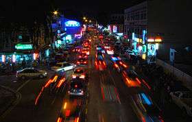
From top left to right: Geylang Road at night, Aerial view of Geylang East, Shophouses along Geylang Road, Seng Ong Temple, Circuit Road, Eunos Bus Interchange, Headquarters of Singapore Post | |||||||||
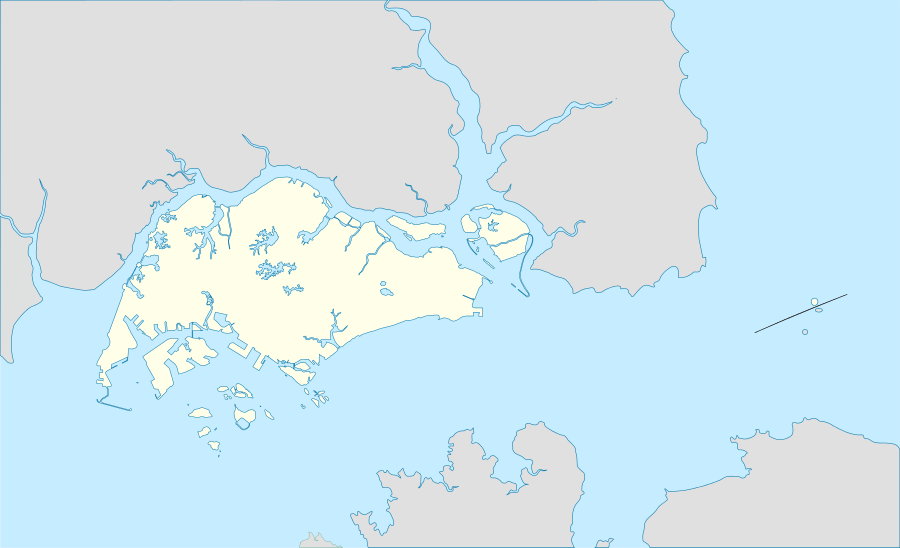 Geylang Location of Geylang within Singapore | |||||||||
| Coordinates: SG 1°19′14″N 103°53′13″E / 1.32056°N 103.88694°E | |||||||||
| Country |
| ||||||||
| Region |
| ||||||||
| CDCs | |||||||||
| Town councils |
| ||||||||
| Constituencies | |||||||||
| Government | |||||||||
| • Mayors |
Central Singapore CDC South East CDC North East CDC | ||||||||
| • Members of Parliament |
Aljunied GRC Jalan Besar GRC MacPherson SMC Marine Parade GRC Mountbatten SMC Potong Pasir SMC | ||||||||
| Area[1][2] | |||||||||
| • Total | 9.64 km2 (3.72 sq mi) | ||||||||
| • Residential | 2.14 km2 (0.83 sq mi) | ||||||||
| Population (2015)[1][2][3] | |||||||||
| • Total | 116,960 | ||||||||
| • Density | 12,000/km2 (31,000/sq mi) | ||||||||
| Demonym(s) |
Official
Colloquial
| ||||||||
| Ethnic groups[3] | |||||||||
| • Chinese | 88,060 | ||||||||
| • Malays | 15,280 | ||||||||
| • Indians | 9,900 | ||||||||
| • Others | 3,730 | ||||||||
| Postal districts | 13, 14, 19 | ||||||||
| Dwelling units | 29,256 | ||||||||
| Projected ultimate | 49,000 | ||||||||


.jpg)
Geylang (Chinese: 芽笼, Tamil: கேலாங்), also known as Geylang Serai, is a planning area and township located on the eastern fringe of the Central Region of Singapore. It is bordered by Hougang and Toa Payoh to the north, Marine Parade to the south, Bedok to the east and Kallang to the west.
Situated just outside Singapore's Central Business District, Geylang is well served by the country's transport network. Geylang Road and Sims Avenue are major roads that run through the area, connecting Geylang with Kallang and the Central Area in the west, as well as Bedok and Changi in the east. Six Mass Rapid Transit stations serve the town, Aljunied, Dakota, Eunos, MacPherson, Mountbatten and Paya Lebar.
Geylang is infamously known as the red-light district of Singapore. With many brothels dotting Geylang Road and along various other lanes in the area. Asian prostitutes mostly from other countries like Thailand, Indonesia, Vietnam and China work in Geylang, and visitors and locals alike flock to the area each evening and stay till morning. The town is home to hundreds of brothels. Some are regulated, while others operate behind the scenes illegally. The houses in Geylang operating in sex practices are easily identifiable; their house numbers are large and bright red.
Etymology
The word Geylang is found early in Singapore's history and also in early topographical maps showing marsh and coconut plantations beside and adjacent to the mouth of the Kallang river, home to the Orang Laut (sea gypsies). One possible etymological link in the stock vocabulary of the Malay is 'geylanggan' meaning to 'twist' or 'crush' a reference to the process of extracting the coconut meat and milk used by the locals to thicken curries in Malay-Chinese (Peranakan) cuisine. The idea persists to this day, of the process of heartache and desperation associated with the broken and hurting lives of those involved in buying and selling of sex and drugs on the streets and in the registered brothel in the area. The word Geylang may be derived from a corrupted spelling of the Malay word 'gelang' which is a type of edible creeper (Portulaca oleracea). This is a more plausible explanation for the name because Malays typically name places based on the abundance of certain plant species (e.g. Melaka after the tree species of the same name) or geological formations (e.g. Bukit Gombak based on the comb-like hill summit).
History
The development of Geylang can best be observed along the main trunk road, Geylang Road, that leads westwards towards the city. Micro-businesses founded by Malay, Indian and Chinese entrepreneurs seized start-up opportunities as mechanics in bicycle or motor repair workshops, suppliers of wood for making boats, houses, furniture and as merchants in iron, of floor and roofing tiles, in rubber and later plastics for all kinds of marine, industrial, factory and home use, including the mosaic of temples, mosques and churches in Geylang that have its roots serving local worshippers in search of spirituality and the divine.
One of the distinctive hallmarks of Geylang architecture is the preservation of its shophouses used by the clan (kinship) associations, set up as a (first) point of contact for newcomers in the migrant wave between 1840 and 1940 for the purpose of integrating the newcomers into the ways and customs of locals. At present the Geylang neighbourhood accurately reflects demographic changes in Singapore (2011) where out of every four Singaporeans, one is a foreigner (Goh, Mar 2011 paper on PRC Immigrants', Social Work Dept, National University of Singapore).
As a strategic and military outpost for the British, the sea lanes off the Straits of Malacca were important to be kept free from pirates and open for shipping. As the British expanded in influence and power, so Singapore stood in the gap between East and West interests as a natural deep-harbour destination that played host to the French, Portuguese, Dutch and other European navies and their men. Other seaports in Asia, from Shanghai to Calcutta, also played a role in the traffic of women and girls for prostitution.
James Francis Warren has studied the death (coroner's) reports in that colonial era that attest to the lives of the Hokkien, Teochew and Hakka and other dialect groups cast out of the Chinese mainland due to famine and abject poverty. His research tells the story of illiterate Chinese migrants working as coolies and rickshaw pullers and gives an accurate description of what life might have been for the poorest of the poor living in Singapore under the British and immediately before the Japanese Occupation.
In his 2008 edition of Pirates, Prostitutes & Pullers, the author traces the roots of prostitution in Singapore and gives an explanation of the eastward shift of Singapore's red-light district from Chinatown that was east of the Singapore river, toward the Hylam Street– Beach Road locality where many Chinese, Japanese and European girls were pimped, and finally across the Kallang river to its present location. Warren's research gives an accurate ethno-social background to prostitution of the young men and women who came to Singapore a hundred years ago, having little or no education, who could not converse, read or write in English and resorted to any and all means to survive the ravages of war, hunger and privation back in the country of origin.
After the war, the heart of the city centre expanded rapidly outward with residential shophouses, hotels and restaurants making their mark on the history of this area including the Gay World amusement park situated just outside the main gate of the old Kallang airport. Remnants of this pre-war history survive to this day that can be seen in the stereotypical Singapore shophouses along and just off the main Geylang thoroughfare. It is in this context of the Asian settlers that stumbled off boats and sampans into mosques, temples and churches to give thanks for journey mercies, that the history of Geylang's red-light district must be read and understood.
Peter Neville, British author of The Rose of Singapore (Monsoon, 2006) writes a novel of Lai Meng, a once famous prostitute in the Geylang area, who falls in love with an R.A.F. serviceman and through marriage crosses over and out of the street communities that were off-limits to the British troops stationed in Singapore during the second world war. The detailed account of life in Geylang during and immediately after the war, the visits to Haw Par Villa, the types of food and services available among the main truck road toward Changi and all of its varied businesses (including the sex trade) stands at back of the reasons why prostitution, while officially illegal and outlawed in the Singapore constitution, is nevertheless seen as an accessible, public expedient and necessarily so in view of the large numbers of single male foreign workers and expatriates on the island.
Infrastructure
The Geylang area is composed of north and south sections that are divided by Geylang Road which stretches for about three kilometres. Throughout the length of Geylang Road, there are lanes (or "lorongs" in the local Malay language) that extend perpendicularly from the main road. The lanes in the north are given odd numbered names (i.e. Lorong 1, Lorong 3, Lorong 5 and so on), and the lanes in the south are given even numbered names (i.e. Lorong 2, Lorong 4, Lorong 6 and so on).
Partly untouched by urban projects and developments and so far spared by the gentrification process that has changed the face of Singapore since the 1970s, Geylang's combination of shophouse scenery and hectic day and night life, including foreign workers quarters and karaoke lounges provides an alternative view of elements the rest of modern Singapore generally does not have. Shophouses along Geylang Road are protected from redevelopment, and many restaurants have sprung up along this major road. Geylang is also known for its durian shops.
Transport
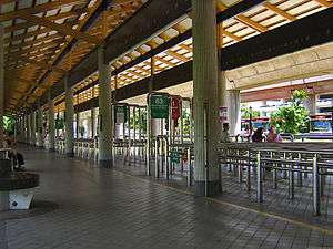
To get to Geylang Road, there are several MRT stations in the vicinity of Geylang Road: Aljunied, Dakota and Paya Lebar stations. There is also the Geylang Lorong 1 Bus Terminal situated in Kallang.
TV shows about Geylang
- Living in Geylang, a 20-episode drama aired on MediaCorp Channel 8 in 1998.
- Pleasure Factory, a 2007 Singaporean-Thai docudrama film set in Geylang.
| Wikimedia Commons has media related to Geylang. |
References
- 1 2 City Population - statistics, maps and charts | Geylang
- 1 2 HDB Key Statistics FY 2014/2015
- 1 2 "Singapore Residents by Planning Area/Subzone, 2015" (XLS). Singapore Department of Statistics.
- Peter K G Dunlop (2000), Street Names of Singapore, Who's Who Publishing, ISBN 981-4062-11-1
- Victor R Savage, Brenda S A Yeoh (2003), Toponymics – A Study of Singapore Street Names, Eastern Universities Press, ISBN 981-210-205-1
| Organisations |  | |
|---|---|---|
| Building Programmes | ||
| Upgrading Programmes |
| |
| Other | ||