Jordan Township, Warren County, Indiana
| Jordan Township | |
|---|---|
| Township | |
|
Agricultural scene west of Stewart | |
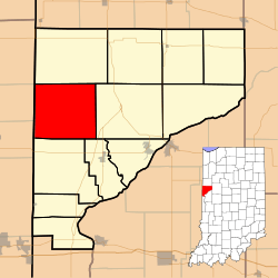 Location of Jordan Township in Warren County | |
 Location of Indiana in the United States | |
| Coordinates: 40°21′01″N 87°27′49″W / 40.35028°N 87.46361°WCoordinates: 40°21′01″N 87°27′49″W / 40.35028°N 87.46361°W | |
| Country | United States |
| State | Indiana |
| County | Warren |
| Government | |
| • Type | Indiana township |
| Area | |
| • Total | 40.56 sq mi (105.0 km2) |
| • Land | 40.55 sq mi (105.0 km2) |
| • Water | 0.02 sq mi (0.05 km2) 0.05% |
| Elevation | 709 ft (216 m) |
| Population (2010) | |
| • Total | 247 |
| • Density | 6.1/sq mi (2.4/km2) |
| Time zone | Eastern (EST) (UTC-5) |
| • Summer (DST) | EDT (UTC-4) |
| GNIS feature ID | 453519 |

Jordan Township is one of twelve townships in Warren County, Indiana, United States. According to the 2010 census, its population was 247 and it contained 105 housing units.[1] It is almost entirely agricultural and contains no incorporated towns.
History
Jordan Township was created in 1850 from a section of the adjacent Liberty Township. At this time the land was marshy and not considered very good for farming, and was used largely for grazing livestock. Starting around 1880, some of the higher ground began to be farmed, and as the population increased this was expanded. The grain grown was either fed to livestock or hauled by wagon to elevators at Ambia, West Lebanon, or Rossville, Illinois.
Geography
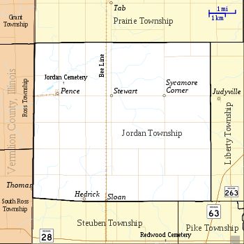
According to the 2010 census, the township has a total area of 40.56 square miles (105.0 km2), of which 40.55 square miles (105.0 km2) (or 99.98%) is land and 0.02 square miles (0.052 km2) (or 0.05%) is water.[1] The small town of Pence lies near the western edge of the township, which is also the Illinois border. An even smaller town, Stewart, is located about 2 miles (3.2 km) east of Pence and now consists mainly of a grain processing facility. Near the southern border of the township lies the town of Hedrick. The town of Sloan once existed just east of Hedrick but no buildings now remain. Likewise, the town of Sycamore Corner was 2 miles (3.2 km) east of Stewart at 40°21′36″N 87°26′04″W / 40.36000°N 87.43444°W but is now entirely gone.
Cemeteries
The township's only cemetery is Jordan Cemetery.[2] It lies just to the northeast of Pence at 40°22′1.21″N 87°30′25.05″W / 40.3670028°N 87.5069583°W; the earliest marker here is from 1850.
Education
Jordan Township is part of the Metropolitan School District of Warren County.[3]
Government
Jordan Township has a trustee who administers rural fire protection and ambulance service, provides relief to the poor, manages cemetery care, and performs farm assessment, among other duties. The trustee is assisted in these duties by a three-member township board. The trustees and board members are elected to four-year terms.[4]
Jordan Township is part of Indiana's 8th congressional district, Indiana House of Representatives District 42,[5] and Indiana State Senate District 38.[6]
References
- 1 2 "Population, Housing Units, Area, and Density: 2010 - County -- County Subdivision and Place -- 2010 Census Summary File 1". United States Census. Retrieved 2013-05-10.
- ↑ "Jordan Cemetery". Geographic Names Information System. United States Geological Survey. Retrieved 2011-01-27.
- ↑ "Corporation Snapshot, M S D Warren County #8115". Indiana Department of Education. Retrieved 2011-01-27.
- ↑ "Government". United Township Association of Indiana. Retrieved 2011-01-06.
- ↑ "Indiana Senate" (PDF). State of Indiana. Retrieved 2013-12-02.
- ↑ "Indiana House Districts" (PDF). State of Indiana. Retrieved 2013-12-02.
- "Jordan Township". Geographic Names Information System. United States Geological Survey. Retrieved 2009-09-24.
- United States Census Bureau TIGER/Line Shapefiles
Bibliography
- Goodspeed, Weston A. (1883). "Part II. History of Warren County". Counties of Warren, Benton, Jasper and Newton, Indiana. Chicago: F. A. Battey and Company. pp. 31–156. Retrieved 2010-09-19.
- Clifton, Thomas, ed. (1913). Past and Present of Fountain and Warren Counties Indiana. Indianapolis: B. F. Bowen and Company. pp. 201–335. Retrieved 2010-09-19.
- Warren County Historical Society (1966). A History of Warren County, Indiana. Williamsport, Indiana.
- Warren County Historical Society (2002). A History of Warren County, Indiana (175th Anniversary Edition). Williamsport, Indiana.
External links

Municipalities and communities of Warren County, Indiana, United States | ||
|---|---|---|
| Towns | ||
| Townships | ||
| Unincorporated communities | ||
| Ghost towns | ||