Independence, Indiana
| Independence | |
|---|---|
| Unincorporated community | |
|
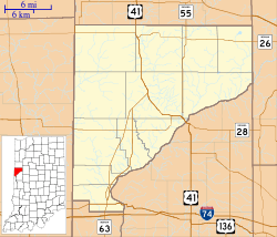
The intersection of Independence and Cicott Roads | |
 Independence  Independence  Independence | |
| Coordinates: 40°20′15″N 87°10′8″W / 40.33750°N 87.16889°WCoordinates: 40°20′15″N 87°10′8″W / 40.33750°N 87.16889°W | |
| Country | United States |
| State | Indiana |
| County | Warren |
| Township | Warren |
| Founded | 1832 |
| Founded by | Zachariah Cicott |
| Elevation[1] | 551 ft (168 m) |
| Time zone | EST (UTC-5) |
| • Summer (DST) | EDT (UTC-4) |
| ZIP code | 47993 |
| Area code(s) | 765 |
| GNIS feature ID | 436723 |
Independence is a small unincorporated community in Warren Township, Warren County, in the U.S. state of Indiana.[2]
History
A trading post existed at this location as early as 1811. The village was laid out on October 5, 1832 by Zachariah Cicott, a French-Indian trader and scout for General William Henry Harrison, on Cicott's Reserve, ground that was given to him by the government for his services. A post office was established on March 24, 1834 and closed on January 31, 1950. Now the town uses the post office in nearby Attica, despite the fact that Attica is in a different county.[3]
The first newspaper in the county was produced in Independence, starting in 1844. It was called the Wabash Register and was run by Enos Canutt.[4]
Geography
Independence is located in the eastern part of the county on the western banks of the Wabash River, about 7 miles (11 km) northeast and upstream of the county seat of Williamsport. The small town of Riverside occupies the opposite bank, which is in Fountain County.[2]
Trivia
- The American folk band Eddie From Ohio has a song on its 2004 album This Is Me called Independence, Indiana.
References
- ↑ "US Board on Geographic Names". United States Geological Survey. October 25, 2007. Retrieved 2016-07-10.
- 1 2 "USGS detail on Independence, Indiana". Retrieved 2007-09-28.
- ↑ Pearson, Willard; Alice Fellure; Jane Fenters; Wanda Lewellen; Patty Wiggins (2002). "Warren Township". A History of Warren County, Indiana (175th Anniversary Edition). Warren County Historical Society.
- ↑ Clifton, Thomas, ed. (1913). Past and Present of Fountain and Warren Counties Indiana. Indianapolis: B. F. Bowen and Company. pp. 249, 320.

Municipalities and communities of Warren County, Indiana, United States | ||
|---|---|---|
| Towns | ||
| Townships | ||
| Unincorporated communities | ||
| Ghost towns | ||