Johnson Covered Bridge No. 28
|
Johnson Covered Bridge No. 28 | |
|
The bridge in October 2012 | |
  | |
| Location | Pennsylvania Route 320, south of Catawissa, Cleveland Township, Pennsylvania |
|---|---|
| Coordinates | 40°52′40″N 76°29′2″W / 40.87778°N 76.48389°WCoordinates: 40°52′40″N 76°29′2″W / 40.87778°N 76.48389°W |
| Area | 0.1 acres (0.040 ha) |
| Built | 1882 |
| Built by | Stine, Daniel |
| Architectural style | Other, Warren Truss |
| MPS | Covered Bridges of Columbia and Montour Counties TR |
| NRHP Reference # | 79003185[1] |
| Added to NRHP | November 29, 1979 |
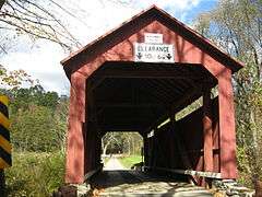
The Johnson Covered Bridge No. 28 is a historic wooden covered bridge located at Cleveland Township in Columbia County, Pennsylvania. It is a 60.8-foot-long (18.5 m), Warren Truss bridge with a metal roof, constructed in 1882. It crosses Mugser Run. It is one of 28 historic covered bridges in Columbia and Montour Counties.[2]
It was listed on the National Register of Historic Places in 1979.[1]
References
| Wikimedia Commons has media related to Johnson Covered Bridge. |
- 1 2 National Park Service (2010-07-09). "National Register Information System". National Register of Historic Places. National Park Service.
- ↑ "National Historic Landmarks & National Register of Historic Places in Pennsylvania" (Searchable database). CRGIS: Cultural Resources Geographic Information System. Note: This includes Bill Pennesi and Susan M. Zacher (n.d.). "National Register of Historic Places Inventory Nomination Form: Johnson Covered Bridge No. 28" (PDF). Retrieved 2011-11-19.
| Topics |   | |
|---|---|---|
| Lists by county |
| |
| Lists by city | ||
| Other lists | ||
| ||
This article is issued from Wikipedia - version of the 11/29/2016. The text is available under the Creative Commons Attribution/Share Alike but additional terms may apply for the media files.