Interstate 505
| ||||
|---|---|---|---|---|
 | ||||
| Route information | ||||
| Defined by Streets and Highways Code § 617 | ||||
| Maintained by Caltrans | ||||
| Length: | 32.99 mi[1] (53.09 km) | |||
| Existed: | 1977 – present | |||
| Major junctions | ||||
| South end: |
| |||
|
| ||||
| North end: |
| |||
| Highway system | ||||
| ||||
.svg.png)
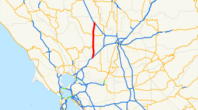
Interstate 505 (I-505) is an Interstate Highway in California between Interstate 80 in Vacaville and Interstate 5 near Dunnigan. I-505 is primarily a rural interstate, but travels through Vacaville and the city of Winters. The interstate is the primary route connecting the San Francisco Bay Area and the northern Sacramento Valley, bypassing Sacramento and its attendant city traffic. Thus, it is a major route for travelers heading directly from the San Francisco Bay Area to the Pacific Northwest.
This route is part of the California Freeway and Expressway System.[2]
Power lines connecting Path 15 to Path 66 follow the highway for a while, until one heads northeast and the other northwest.
Route description
The southern terminus of I-505 is at I-80 next to the Nut Tree Airport in the Nut Tree area in Vacaville. From there, it travels north about ten miles through rural areas near the western edge of the Sacramento Valley before reaching Winters. I-505 then skirts the eastern city limits of Winters, intersecting with State Route 128 – the only exit in Winters. After leaving that city, the interstate then proceeds north through rural areas again for about 20 miles until it reaches its northern terminus with I-5 near Dunnigan.
For most of its length, I-505 is a four-lane freeway, which is typical for rural interstates in California.
History
What is now I-505 was originally conceived as part of a loop Interstate with a directional suffix, I-5W.[3] However, I-5W and most of the other Interstates around the country with directional suffixes were eventually renumbered or eliminated, sans I-35E and I-35W in Texas and Minnesota. The former route of I-5W now corresponds to I-580 from I-5 south of Tracy to Oakland, I-80 from Oakland to Vacaville, and I-505 from Vacaville to I-5 near Dunnigan.
Exit list
| County | Location | mi [4][5][6] | km | Exit [7] | Destinations | Notes |
|---|---|---|---|---|---|---|
| Solano | Vacaville | 0.00 | 0.00 | 1 | Southbound exit and northbound entrance; signed as exit 1A (west) and 1B (east); south end of I-505; I-80 exit 56 | |
| 0.00 | 0.00 | Orange Drive, Nut Tree Road | Northbound exit (from I-80 east) and entrance | |||
| 0.00 | 0.00 | 1B | Monte Vista Avenue | Southbound exit and entrance (to I-80 east) | ||
| 1.45 | 2.33 | 1C | Vaca Valley Parkway | Signed as exit 1 northbound | ||
| 3.06 | 4.92 | 3 | Midway Road | |||
| | 5.57 | 8.96 | 6 | Allendale Road | ||
| | 10.43 | 16.79 | 10 | Putah Creek Road | ||
| Yolo | | 11.03 | 17.75 | 11 | ||
| | 14.66 | 23.59 | 15 | Road 29A | ||
| | 17.16 | 27.62 | 17 | Road 27 | ||
| | 21.25 | 34.20 | 21 | |||
| | 24.06 | 38.72 | 24 | Road 19 | ||
| | 28.08 | 45.19 | 28 | |||
| | 30.74 | 49.47 | 31 | Road 12A | ||
| | 32.99 | 53.09 | Northbound exit and southbound entrance; north end of I-505; I-5 south exit 553 | |||
| 1.000 mi = 1.609 km; 1.000 km = 0.621 mi | ||||||
References
- ↑ "January 1, 2006 California Log of Bridges on State Highways". Dot.ca.gov. Retrieved 2013-01-26.
- ↑ "CA Codes (shc:250-257)". Leginfo.ca.gov. Retrieved 2013-01-26.
- ↑ "California Highways-Routes 1-8". California Highways. Retrieved 2012-09-03.
- ↑ California Department of Transportation, State Truck Route List (XLS file), accessed February 2008 Archived February 5, 2009, at the Wayback Machine.
- ↑ California Department of Transportation, Log of Bridges on State Highways, July 2007
- ↑ California Department of Transportation, All Traffic Volumes on CSHS, 2005 and 2006
- ↑ California Department of Transportation, California Numbered Exit Uniform System, Interstate 505 Freeway Interchanges, Retrieved on 2009-02-07.
| ||