Washington State Route 900
| ||||
|---|---|---|---|---|
|
Map of King County in western Washington with SR 900 highlighted in red | ||||
| Route information | ||||
| Auxiliary route of I‑90 | ||||
| Defined by RCW 47.17.825 | ||||
| Maintained by WSDOT | ||||
| Length: | 16.20 mi[1] (26.07 km) | |||
| Existed: | 1964[2] – present | |||
| Major junctions | ||||
| West end: |
| |||
|
| ||||
| East end: |
| |||
| Location | ||||
| Counties: | King | |||
| Highway system | ||||
| ||||

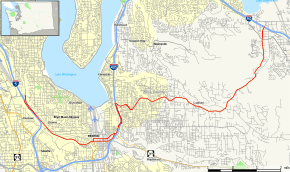
State Route 900 (SR 900) is a 16.20-mile-long (26.07 km) state highway serving suburban King County, Washington. It travels east from an interchange with Interstate 5 (I-5) in northern Tukwila through the city of Renton and into the Issaquah Alps to reach the city of Issaquah, where the highway ends at an interchange with I-90.
Route description
SR 900 begins as an extension of Martin Luther King Jr. Way South at an intersection with Boeing Access Road, east of its interchange with I-5 under an elevated section of the Central Link light rail line, in the Allentown neighborhood of northern Tukwila.[3] The four-lane highway splits at a basketweave interchange with I-5, with the southbound lanes of SR 900 traveling over the freeway twice.[4] The roadway continues southeast into Skyway whilst parallel to I-5 and the BNSF South Seattle railyard.[5] SR 900 turns east and becomes Sunset Boulevard as it enters Renton, following the Black River and a BNSF branch railroad,[6] to an intersection with SR 167 at Rainier Avenue.[7][8]
The highway splits into a couplet on 2nd and 3rd streets for several blocks in downtown Renton, serving the Renton transit center,[9] before returning to two-way traffic at a bridge over the Cedar River, downstream of the Renton branch of the King County Library System.[10][11] SR 900 then continues east, around the northwest side of Liberty Park, before turning north to briefly parallel I-405 after its interchange with SR 169.[12] The highway then joins I-405 in a short concurrency for 0.90 miles (1.45 km),[1][13][14] traveling east through Renton's suburbs towards the East Renton Highlands. The highway transitions into a two-lane country road, entering unincorporated King County while following Tibbetts Creek northeastward between Cougar and Squak mountains, part of the Issaquah Alps highlands. SR 900 enters Issaquah as the four-lane 17th Avenue, passing the Issaquah park and ride,[15] before ending at a partial cloverleaf interchange with I-90 south of Lake Sammamish State Park.[7][8][16]
Every year, the Washington State Department of Transportation (WSDOT) conducts a series of surveys on its highways in the state to measure traffic volume. This is expressed in terms of average annual daily traffic (AADT), which is a measure of traffic volume for any average day of the year. In 2014, WSDOT calculated that the busiest section of SR 900 was at its bridge over the Cedar River in downtown Renton, carrying 48,000 vehicles, while the least busiest section was on the eastbound lanes of the one-way pair in Renton, carrying 6,300 vehicles.[17]
History
The road now designated SR 900 was originally added to the state highway system in 1909, as an extension of the Snoqualmie Pass Road (State Road 7) which was completed for through traffic across the pass in 1915. At the time the highway was the main thoroughfare between Seattle and Spokane, with a route then around the south end of Lake Washington.[18] In 1913 the highway was renamed the Sunset Highway,[19] which is still an informal moniker today.
The road became State Road 2 in 1923 and Primary State Highway 2 in 1937. In 1926 the highway was co-designated to be part of US 10. The legislature in 1931 also designated the route as part of the Washington Loop Highway.
The opening of the Lake Washington Floating Bridge across Lake Washington in 1940 moved US 10/PSH 2 to the direct route, and the old alignment became Alternate US 10 and PSH 2 RE (for Renton). In 1955,[20] Alternate US 10 was dropped, and it became SR 900 in 1964.
After April 1, 1992, the stretch of SR 900 between I-90 exit 3 at Rainier Avenue and along Martin Luther King Jr. Way to the Boeing Access Road was dropped from the officially designated highway. The west end of SR 900 is now milepost 5.93 due to this truncation; the east end is milepost 21.64.
Major intersections
The entire highway is in King County.
| Location | mi[1] | km | Destinations | Notes | |
|---|---|---|---|---|---|
| Tukwila | 0.00 | 0.00 | Interchange; eastbound entrance and westbound exit; continues north as Martin Luther King Jr. Way South | ||
| 0.55 | 0.89 | Interchange | |||
| Renton | 3.97 | 6.39 | |||
| 4.56 | 7.34 | ||||
| 5.10 | 8.21 | Interchange | |||
| 5.62 | 9.04 | Interchange; west end of I-405 concurrency; westbound exit and eastbound entrance | |||
| 6.52 | 10.49 | Interchange; east end of I-405 concurrency | |||
| Issaquah | 16.20 | 26.07 | Interchange; continues as 17th Avenue Northwest | ||
1.000 mi = 1.609 km; 1.000 km = 0.621 mi
| |||||
References
- 1 2 3 Multimodal Planning Division (January 15, 2015). State Highway Log Planning Report 2014, SR 2 to SR 971 (PDF) (Report). Washington State Department of Transportation. pp. 1668–1678. Retrieved June 8, 2015.
- ↑ "47.17.825: State route No. 900". Revised Code of Washington. Washington State Legislature. 1991 [1970]. Retrieved May 28, 2014.
- ↑ Transportation Data & GIS Office (October 6, 2011). "SR 5 - Exit 158: Junction Boeing Access Road" (PDF). Washington State Department of Transportation. Retrieved June 8, 2015.
- ↑ Transportation Data & GIS Office (February 29, 2012). "SR 5 - Exit 157: Junction SR 900/M L King Way" (PDF). Washington State Department of Transportation. Retrieved June 8, 2015.
- ↑ "South Seattle Intermodal Facility". BNSF Railway. Retrieved June 8, 2015.
- ↑ 2013 Washington State Rail System (PDF) (Map). Washington State Department of Transportation. February 2014. Retrieved June 8, 2015.
- 1 2 Google (June 9, 2015). "State Route 900" (Map). Google Maps. Google. Retrieved June 9, 2015.
- 1 2 "Puget Sound Area: Seattle, Tacoma, Bellevue, Everett, Bremerton & Vicinity" (PDF) (Map). Washington State Highways, 2014–15 (PDF). Washington State Department of Transportation. 2014. § M2, M3. OCLC 5673231. Retrieved June 8, 2015.
- ↑ "Renton Transit Center/Park-and-Ride". Sound Transit. Retrieved June 8, 2015.
- ↑ Transportation Data & GIS Office (May 4, 2009). "SR 900: Junction SR 900 CO 2nd Street" (PDF). Washington State Department of Transportation. Retrieved June 8, 2015.
- ↑ "Directions to Renton Library". King County Library System. Retrieved June 8, 2015.
- ↑ Transportation Data & GIS Office (March 17, 2014). "SR 405 - Exit 4: Junction SR 169/SR 900" (PDF). Washington State Department of Transportation. Retrieved June 8, 2015.
- ↑ Transportation Data & GIS Office (March 17, 2014). "SR 405 - Exit 4: Junction SR 900/Sunset Boulevard" (PDF). Washington State Department of Transportation. Retrieved June 8, 2015.
- ↑ Transportation Data & GIS Office (April 2, 2008). "SR 405 - Exit 5: Junction SR 900/N Park Drive/Sunset Boulevard" (PDF). Washington State Department of Transportation. Retrieved June 8, 2015.
- ↑ "Issaquah Transit Center". Sound Transit. Retrieved June 8, 2015.
- ↑ Transportation Data & GIS Office (June 2, 2010). "SR 90 - Exit 15: Junction SR 900/Lake Sammamish State Park" (PDF). Washington State Department of Transportation. Retrieved June 8, 2015.
- ↑ 2014 Annual Traffic Report (PDF) (Report). Washington State Department of Transportation. 2014. pp. 209–210. Retrieved June 8, 2015.
- ↑ "About US 2 WA". Roadnow.com. Retrieved 2013-11-12.
- ↑ http://www.wsdot.wa.gov/NR/rdonlyres/65A1FA26-0800-428A-A2AD-BEBA658D7A4F/0/40yearsReport.pdf
- ↑ "Alternate U.S. Highways (US 1 to US 40)". Us-highways.com. Retrieved 2013-11-12.