Icehouse Canyon, Arizona
| Icehouse Canyon, Arizona | |
|---|---|
| Census-designated place | |
 Icehouse Canyon  Icehouse Canyon | |
| Coordinates: 33°21′32″N 110°47′8″W / 33.35889°N 110.78556°WCoordinates: 33°21′32″N 110°47′8″W / 33.35889°N 110.78556°W | |
| Country | United States |
| State | Arizona |
| County | Gila |
| Area | |
| • Total | 4.9 sq mi (12.7 km2) |
| • Land | 4.9 sq mi (12.7 km2) |
| • Water | 0.0 sq mi (0.0 km2) |
| Elevation | 3,798 ft (1,158 m) |
| Population (2010) | |
| • Total | 677 |
| • Density | 138/sq mi (53.3/km2) |
| Time zone | MST (no DST) (UTC-7) |
| Area code(s) | 928 |
| FIPS code | 04-34980 |
| GNIS feature ID | 2582800 |
Icehouse Canyon is a census-designated place (CDP) in Gila County, Arizona, United States. The population was 677 at the 2010 census.[1]
Geography
The CDP is located in southern Gila County, bordered to the north by the city of Globe, the county seat, and to the east by the Six Shooter Canyon CDP. Icehouse Canyon is a mountain valley that extends southwest up into Tonto National Forest. The mouth of the canyon is at its northern end, at Pinal Creek, which flows northwest through the center of Globe. Residences in the community are built along Icehouse Canyon Road and along Kellner Canyon Road, which branches to the west-southwest off Icehouse Canyon. According to the United States Census Bureau, the CDP has a total area of 4.9 square miles (12.7 km2), all of it land.[1]
References
- 1 2 "Geographic Identifiers: 2010 Demographic Profile Data (G001): Icehouse Canyon CDP, Arizona". U.S. Census Bureau, American Factfinder. Retrieved October 31, 2016.
Municipalities and communities of Gila County, Arizona, United States | ||
|---|---|---|
| City | 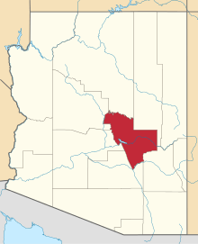 | |
| Towns | ||
| CDPs |
| |
| Unincorporated communities | ||
| Indian reservations | ||
| Ghost towns | ||
| Footnotes | ‡This populated place also has portions in an adjacent county or counties | |