Iba Airport
| Iba Airport Paliparan ng Iba Pagtayaban ti Iba | |||||||||||
|---|---|---|---|---|---|---|---|---|---|---|---|
 | |||||||||||
| IATA: none – ICAO: RPUI | |||||||||||
| Summary | |||||||||||
| Airport type | Public | ||||||||||
| Operator | Air Transportation Office | ||||||||||
| Serves | Iba, Zambales | ||||||||||
| Location | Barangay Santo Rosario, Iba, Zambales | ||||||||||
| Elevation AMSL | 1.5 m / 5 ft | ||||||||||
| Coordinates | 15°19′33.49″N 119°58′6.46″E / 15.3259694°N 119.9684611°ECoordinates: 15°19′33.49″N 119°58′6.46″E / 15.3259694°N 119.9684611°E | ||||||||||
| Runways | |||||||||||
| |||||||||||
Iba Airport (Filipino: Paliparan ng Iba, Ilocano: Pagtayaban ti Iba) (ICAO: RPUI) is an airport serving the general area of Iba, located in the province of Zambales in the Philippines. It is one of the five airports in Zambales. It is classified as a feeder airport by the Air Transportation Office, a body of the Department of Transportation and Communications that is responsible for the operations of not only this airport but also of all other airports in the Philippines except the major international airports. Iba Airport serves as a training area for the Philippine Air Force and today, most of the traffic that goes in Iba Airport are general aviation.
Images
 Runway of Iba Airport panorama
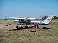 Parked private plane
 Aviation school plane
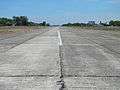 The short runway
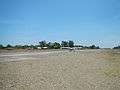 Descending plane of student pilot with professor
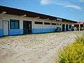 Civil Aviation Authority of the Philippines office in the center of the Airport
References
External links
| Wikimedia Commons has media related to Iba Airport. |
- Coordinates
- List of airports in Zambales, Philippines (excluding heliports and closed airports)
- Civil Aviation Authority of the Philippines
This article is issued from Wikipedia - version of the 1/6/2016. The text is available under the Creative Commons Attribution/Share Alike but additional terms may apply for the media files.