Hurricane Ekeka
| Category 3 major hurricane (SSHWS/NWS) | |
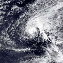 Hurricane Ekeka near peak intensity | |
| Formed | January 28, 1992 |
|---|---|
| Dissipated | February 9, 1992 |
| Highest winds |
1-minute sustained: 115 mph (185 km/h) |
| Lowest pressure | ≤ 985 mbar (hPa); 29.09 inHg |
| Fatalities | None reported |
| Damage | Minimal |
| Areas affected | Marshall Islands, Chuuk |
| Part of the 1992 Pacific hurricane season 1992 Pacific typhoon season | |
Hurricane Ekeka was an unusual Pacific tropical cyclone that attained major hurricane status during the month of February. The first storm of the 1992 Pacific hurricane season, Ekeka developed on January 28 well to the south of Hawaii. It gradually intensified to reach major hurricane status on February 2, although it subsequently began to weaken due to unfavorable wind shear. It crossed the International Date Line as a weakened tropical storm, and shortly thereafter degraded to tropical depression status. Ekeka continued westward, passing through the Marshall Islands and later over Chuuk State, before dissipating on February 9 about 310 miles (500 km) off the north coast of Papua New Guinea. The storm did not cause any significant damage or deaths.
Meteorological history

During the El Niño of 1991–92, as typical with other such events, the monsoon trough extended into the central north Pacific Ocean, which is the body of water between the International Date Line and 140°W. At the same time, sea surface temperatures near the equator were anomalously warm, and wind shear values were low.[1] At the end of January, a large area of convection persisted for several days near the north side of the equator. By January 23, several ships reported squalls and strong southwesterly winds in the region.[2] The Central Pacific Hurricane Center (CPHC) began monitoring the system on January 26,[3] while it was located about 950 miles (1530 km) south of Ka Lae, the southernmost point in Hawaii.[4] The disturbance organized further as it tracked westward, and on January 28 it developed into Tropical Depression One-C, located a short distance north of Kiritimati and east of Tabuaeran.[2]
With favorable conditions, the depression quickly intensified into a tropical storm; upon doing so, it was named Ekeka by the CPHC, which is Hawaiian for Edgar. Ekeka continued gradually intensifying while moving slowly west-northwestward, and it attain hurricane status on January 30 about 100 miles (160 km) northwest of Palmyra Atoll. On February 2, the hurricane attained peak winds of 115 mph (185 km/h), making Ekeka a major hurricane, or Category 3 hurricane on the Saffir-Simpson scale.[2] Subsequently, it began to weaken due to increased wind shear, and concurrently its forward motion increased as the subtropical ridge strengthened to the north of the hurricane.[3] A large trough in the Westerlies increased the wind shear, which weakened Ekeka to a tropical storm early on February 3. Later that day, it crossed the International Date Line into the western Pacific Ocean;[2] both of the Joint Typhoon Warning Center (JTWC) and the Japan Meteorological Agency (JMA) assessed the storm's winds at 50 mph (85 km/h).[3][5] Shortly before that, the JMA assessed the pressure as 985 mbar, which is the lowest known minimum central pressure associated with the storm;[5] the CPHC did not include pressure in their year-end report.[2]
Tropical Storm Ekeka continued weakening, degrading to tropical depression status by February 4. The depression moved quickly through the Marshall Islands, and on February 6 turned to the west-southwest.[3] On February 8, the JMA declared Ekeka dissipated;[5] however, the JTWC continued monitoring the system, with Ekeka passing over Chuuk as a weak depression.[3] Early on February 9, the JTWC declared Ekeka dissipated about 800 miles (1300 km) east-southeast of Palau, or about 310 miles (500 km) off the north coast of Papua New Guinea.[4]
Impact and records
No deaths were reported in association with Ekeka.[2] The storm passed through the Marshall Islands without causing significant impact. When Ekeka hit the island of Chuuk, winds of 20 mph (32 km/h) were reported.[3] While in the central Pacific Ocean, Ekeka became one of only three tropical cyclones on record to be located within the Palmyra Atoll Exclusive Economic Zone; Ekeka was the only hurricane within the area.[6]
Ekeka is most unusual for its formation in January.[2] Tropical cyclones rarely form east of the International Date Line outside of the tropical cyclone season,[4] which starts May 15 in the eastern Pacific and June 1 in the central Pacific, and ends on November 30 in both regions.[7] In the official Pacific hurricane database, Ekeka was the second tropical cyclone on record to occur in January or February within the Pacific Ocean east of the International Date Line, after Tropical Storm Winona[4][8] of 1989. It is third earliest cyclone on record within the basin, behind Hurricane Pali of 2016, and the aforementioned Winona.
See also
- List of off-season Pacific hurricanes
- List of Pacific hurricanes
- List of Equatorial tropical cyclones
References
- ↑ Kevin R. Kodama & Steven Businger (1998). "Weather and Forecasting Challenges in the Pacific Region of the National Weather Service" (PDF). American Meteorological Society. Retrieved 2008-09-20.
- 1 2 3 4 5 6 7 Central Pacific Hurricane Center (1992). "The 1992 Central Pacific Tropical Cyclone Season". Retrieved 2008-09-20.
- 1 2 3 4 5 6 Mundell (1993). "Tropical Storm Ekeka (01C)" (PDF). Joint Typhoon Warning Center. Retrieved 2008-09-20.
- 1 2 3 4 National Hurricane Center; Hurricane Research Division; Central Pacific Hurricane Center. "The Northeast and North Central Pacific hurricane database 1949–2015". United States National Oceanic and Atmospheric Administration's National Weather Service. A guide on how to read the database is available here.
- 1 2 3 RSMC Tokyo-Typhoon Center Japan Meteorological Agency. "RSMC Best Track Data (Text) 1990-1999" (TXT). Government of Japan. Retrieved 2008-09-20.
- ↑ Rusty Brainard; et al. (2005). "The State of Coral Reef Ecosystems of the U.S. Pacific Remote Island Areas" (PDF). National Oceanic and Atmospheric Administration. Retrieved 2008-09-20.
- ↑ "Tropical Cyclone Climatology". FAQ. Central Pacific Hurricane Center. Retrieved 2007-11-25.
- ↑ Pao-Shin Chu; Peng Wu (2008). Climatic Atlas of Tropical Cyclone Tracks over the Central North Pacific (PDF) (Report). University of Hawaii-Manoa. Retrieved August 2, 2015.
Tropical cyclones of the 1992 Pacific hurricane season | ||
|---|---|---|
 | ||
| ||