Hurricane Lester (1992)
| Category 1 hurricane (SSHWS/NWS) | |
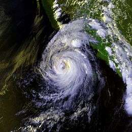 Hurricane Lester near landfall | |
| Formed | August 20, 1992 |
|---|---|
| Dissipated | August 24, 1992 |
| Highest winds |
1-minute sustained: 80 mph (130 km/h) |
| Lowest pressure | 985 mbar (hPa); 29.09 inHg |
| Fatalities | 3 direct |
| Damage | $3 million (1992 USD) |
| Areas affected | Baja California, northwestern Mexico, southwestern United States |
| Part of the 1992 Pacific hurricane season | |
Hurricane Lester was the first Pacific tropical cyclone to enter the United States as a tropical storm since 1967. The twelfth named storm and seventh hurricane of the 1992 Pacific hurricane season, Lester formed on August 20 from a tropical wave southwest of Mexico. The tropical storm moved generally northwestward while steadily intensifying. After turning to the north, approaching the Mexican coast, Lester attained hurricane status. The hurricane reached peak winds of 85 mph (140 km/h) before making landfall on west-central Baja California. The system weakened while moving across the peninsula and then over northwestern Mexico. Not long after entering Arizona, Lester weakened to a tropical depression, and dissipated on August 24, 1992, over New Mexico.
In Mexico, the hurricane resulted in $3 million in damage (1992 USD, $4.7 million 2011 USD). It also left 5,000 people left homeless, and was responsible for three fatalities. The remnants of Lester also produced moderate rainfall and minor flooding across southern California, Colorado, Arizona and New Mexico, as well as rare August snow in the Rocky Mountains.
Meteorological history

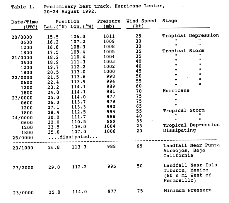
A weak tropical wave moved off the coast of Africa on August 7. It tracked across the Atlantic Ocean and Caribbean Sea without development due to strong wind shear. The wave then split into two, with the northern portion dissipating over Cuba on August 15 and the southern portion continuing westward. The wave crossed Central America and entered the Pacific Ocean on August 16. Deep convection increased over the wave upon entering the Pacific, and early on August 19 it started to become better organized. After the development of a low-level circulation, the system organized into Tropical Depression Fourteen-E on August 20 while located about 275 miles (445 km) south-southwest of Manzanillo, Colima.[1]
The depression gradually tracked northwestward at 15 mph (24 km/h).[1] Although the center of the depression was initially uncertain,[2] it slowly strengthened and steadily organized. The depression attained tropical storm status late on August 20, upon which the storm was named Lester. The cyclone continued to the northwest, and passed directly over Socorro Island on August 21. By early the next day, an eastward moving trough weakened the ridge to its north, resulting in a to turn to the north.[1] Around this time, forecasters at the National Hurricane Center predicted the storm would not strengthen to hurricane intensity before making landfall.[3] Despite this, Lester intensified into a hurricane late on August 22 while located about 240 miles (385 km) west of La Paz in Baja California Sur.[1]

The hurricane continued to organize and banding-type eye soon formed. Early on August 23 it attained peak winds of 85 mph (140 km/h) with a minimum central pressure of 985 mbar (hPa; 29.09 inHg). Lester weakened steadily as the storm turned to the northeast, and made landfall as a minimal hurricane near Punta Abreojos, Baja California Sur about ten hours after reaching peak intensity. It degenerated into a tropical storm while crossing the Baja California Peninsula. After passing through the northern Gulf of California, it made a second landfall near Isla Tiburon in the state of Sonora.[1] Lester entered Arizona as a tropical storm on August 24, the first time since Hurricane Katrina in 1967 that an Eastern Pacific tropical cyclone entered the United States with winds of at least tropical storm intensity. Lester maintained tropical storm status until it weakened into a tropical depression near Tucson, Arizona. Later that day, the low level circulation dissipated over New Mexico, and Lester ceased to exist as a tropical cyclone.[4] The storms remnants transitioned into an extratropical cyclone as it continued to the north-northeast ahead of an approaching trough,[5] and merged with the remnants of Hurricane Andrew on August 29 over Pennsylvania.[6]
Preparations and Impact

Mexico
The Government of Mexico issued tropical storm watches and warnings for Baja California on August 21. The following day, a hurricane warning was issued for the peninsula from Punta Eugenia southward to Cabo San Lazaro. The government of Mexico also issued a tropical storm warning for the Sonora and Sinaloa mainland from Cabo Tepopa to Los Mochis. All watches and warnings were discontinued as the storm weakened and dissipated.[7] The threat of the hurricane prompted the evacuation of about 10,000 residents.[8]
No observations exist for the duration when Lester, as a tropical depression, moved over Socorro Island, while winds were estimated to have reached 37 mph (59 km/h). However, a station reported winds of 23 mph (37 km/h) six hours after Lester passed over Socorro Island.[1] Several ships came in contact with Lester, with one in the eye reporting hurricane-force winds for 11 hours on August 22.[1] The ship in the eye reported rough seas, causing it to roll 33° to each side and thus was responsible for a large amount of cargo to go overboard.[9]
Hurricane Lester produced heavy rainfall across its path through the Baja California Peninsula and Sonora. Peak rainfall occurred in Mulege with 13.58 in (345 mm).[10] A weather station in Presa Rodriquez reported 8.66 inches (203 mm) of precipitation, with several other locations reporting over 2 inches (50 mm). The heavy rainfall caused extensive flood damage to the west of Hermosillo, destroying some entire communities and flooding a large highway.[9] Roads were washed out, and power lines were knocked out.[11] Waves up to 20 ft (6.1 m) were recorded. Flash flooding from Lester caused 10,000 people to be evacuated from their homes.[12] In addition, mudslides killed three people,[8] and left 5,000 homeless.[9] The storm resulted in $3 million (1992 USD), equivalent to $4.7 million (2011 USD). The Mexican Army provided relief efforts to residents after the storm.[8]
United States
The remnants of Lester produced heavy rainfall across the Southwestern United States. In Arizona, rainfall amounted to over 5 inches (125 mm) near Phoenix and Tucson, with much of the rest of the state reporting over 1 inch (25 mm). Moderate rainfall was also reported in western New Mexico and southern Utah, while one location in southwestern Colorado reported over 5 inches (125 mm) of precipitation.[10] In the later location,rains caused flash flooding of arroyos and a mudslide along U.S. Route 180.[13] Additional rainfall caused moderate flooding in Denver. In addition to the rainfall, moisture from the remnants of Lester dropped 2 to 4 inches (50 to 100 mm) of snow across portions of Colorado, causing traffic problems in mountainous areas.[14] A weather station on Mt. Harvard recorded about 4 inches (100 mm) of snow during Lester's passage through Colorado.[5] Moisture enhanced from a cold front,[15] the remnants Lester extended through the eastern United States, with Mattoon, Illinois reporting a peak of 5.96 inches (151 mm).[10] In all, rain from Lester caused rainfall records in Minnesota, Nebraska, Colorado, and North Dakota.[16]
See also
References
- 1 2 3 4 5 6 7 Edward Rappaport (24 August 1992). "Hurricane Lester Preliminary Tropical Cyclone Report". National Hurricane Center (NHC). Retrieved 2007-01-25.
- ↑ Edward Rappaport (1992-08-20). "Tropical Depression Fourteen-E Discussion Three". Retrieved 2007-01-25.
- ↑ Robert Pasch (1992). "Tropical Storm Lester Discussion Ten". Retrieved 2007-01-25.
- ↑ Miles B. Lawrence and Edward Rappaport (1993). "Eastern North Pacific Hurricane Season of 1992". NHC. Retrieved 2007-01-31.
- 1 2 Michael Dickinson and L. F. Bosart and K. L. Corbosiero (2006). "The extratropical transitions of eastern Pacific Hurricane Lester (1992) and Atlantic Hurricane Andrew (1992)". American Meteorlogical Society. Retrieved 2007-01-26.
- ↑ Florida Historical Society (2003). "Today in Florida's History". Retrieved 2007-01-31.
- ↑ Edward Rappaport (24 August 1992). "Hurricane Lester Preliminary Tropical Cyclone Report, Page 3". NHC. Retrieved 2007-01-25.
- 1 2 3 Mercury News Wire Services (1992-08-25). "Hurricane Lester kills 3 in Mexico". San Jose Mercury News. Retrieved 2007-01-23.
- 1 2 3 Edward Rappaport (24 August 1992). "Hurricane Lester Preliminary Tropical Cyclone Report, Page 2". NHC. Retrieved 2007-01-25.
- 1 2 3 David Roth (2006). "Rainfall Summary for Hurricane Lester". Hydrometeorological Prediction Center. Retrieved 2007-01-31.
- ↑ Association Press (1992-08-26). "Hurricane Lester kills 3 in Mexico". Toledo Blade. Retrieved 2011-01-16.
- ↑ Association Press (1992-08-25). "Mexico hit, too". Elensburg Daily Record. Retrieved 2011-01-16.
- ↑ "Storm Data August 1992" (PDF). 34 (8). National Climatic Data Center: 115. Retrieved 2012-03-26.
- ↑ Bill Scanlon (1992). "Pacific Storm Chills State, Floods Denver". Rocky Mountain News. Retrieved 2007-01-23.
- ↑ "Hurricane closes in on Gulf". The Union Democrat. 1992-08-25. Retrieved 2011-01-16.
- ↑ Roth, David M. (April 29, 2015). "Tropical Cyclone Point Maxima". Tropical Cyclone Rainfall Data. United States Weather Prediction Center. Retrieved May 8, 2016.
Tropical cyclones of the 1992 Pacific hurricane season | ||
|---|---|---|
 | ||
| ||