Huntsdale, Missouri
| Huntsdale, Missouri | |
|---|---|
| Area[1] | |
| • Total | 0.02 sq mi (0.05 km2) |
| • Land | 0.02 sq mi (0.05 km2) |
| • Water | 0 sq mi (0 km2) |
| Population (2010)[2] | |
| • Total | 31 |
| • Estimate (2012[3]) | 32 |
| • Density | 1,550.0/sq mi (598.5/km2) |
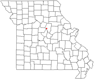
Huntsdale is a village in Boone County, Missouri, United States. It is part of the Columbia, Missouri Metropolitan Statistical Area. The population was 31 at the 2010 census.
The area was first settled in 1817, making it the second oldest settlement in Boone County.[4] The village was founded on August 1, 1892 and named after William Burch Hunt,[5] a landowner. Huntsdale was first incorporated in 1906, but that status eventually fell into neglect and the last village council election took place in 1929.[4]
Due mainly to an influx of residential development in the area, Huntsdale was reincorporated in February 2003 and its first elections were held two months later.[6][7]
The center of activity in Huntsdale is Katfish Katy's , a small general store that sits beside the Katy Trail and features a campground and boat ramp. Katy's Little Lodge , a bed and breakfast, is another notable business in the village.
Geography
According to the United States Census Bureau, the village has a total area of 0.02 square miles (0.05 km2), all of it land.[1]
Demographics
| Historical population | |||
|---|---|---|---|
| Census | Pop. | %± | |
| 1910 | 91 | — | |
| 1930 | 151 | — | |
| 2010 | 31 | — | |
| Est. 2015 | 31 | [8] | 0.0% |
2010 census
As of the census[2] of 2010, there were 31 people, 15 households, and 11 families residing in the village. The population density was 1,550.0 inhabitants per square mile (598.5/km2). There were 15 housing units at an average density of 750.0 per square mile (289.6/km2). The racial makeup of the village was 100.0% White. Hispanic or Latino of any race were 3.2% of the population.
There were 15 households of which 6.7% had children under the age of 18 living with them, 40.0% were married couples living together, 20.0% had a female householder with no husband present, 13.3% had a male householder with no wife present, and 26.7% were non-families. 20.0% of all households were made up of individuals and 13.4% had someone living alone who was 65 years of age or older. The average household size was 2.07 and the average family size was 2.09.
The median age in the village was 50.5 years. 3.2% of residents were under the age of 18; 6.5% were between the ages of 18 and 24; 32.3% were from 25 to 44; 45.2% were from 45 to 64; and 12.9% were 65 years of age or older. The gender makeup of the village was 48.4% male and 51.6% female.
References
- 1 2 "US Gazetteer files 2010". United States Census Bureau. Archived from the original on January 24, 2012. Retrieved 2012-07-08.
- 1 2 "American FactFinder". United States Census Bureau. Retrieved 2012-07-08.
- ↑ "Population Estimates". United States Census Bureau. Archived from the original on June 17, 2013. Retrieved 2013-05-30.
- 1 2 Huntsdale History
- ↑ Eaton, David Wolfe (1916). How Missouri Counties, Towns and Streams Were Named. The State Historical Society of Missouri. p. 212.
- ↑ "Tinier towns hold onto identities as county develops". Columbia Daily Tribune. 2007-06-17. Archived from the original on 2007-09-27. Retrieved 2007-08-06.
- ↑ "Huntsdale board elects mayor, clerk". Columbia Daily Tribune. 2003-04-22. Retrieved 2007-08-06.
- ↑ "Annual Estimates of the Resident Population for Incorporated Places: April 1, 2010 to July 1, 2015". Retrieved July 2, 2016.
- ↑ "Census of Population and Housing". Census.gov. Archived from the original on May 11, 2015. Retrieved June 4, 2015.
External links
Municipalities and communities of Boone County, Missouri, United States | ||
|---|---|---|
| Cities | 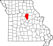 | |
| Villages | ||
| Townships | ||
| Unincorporated communities | ||
| Ghost towns | ||
| Footnotes | ‡This populated place also has portions in an adjacent county or counties | |
Coordinates: 38°54′42″N 92°28′21″W / 38.91167°N 92.47250°W