Hokuto, Yamanashi
| Hokuto 北杜市 | |||
|---|---|---|---|
| City | |||
|
Keep farm in Kiyosato Plateau | |||
| |||
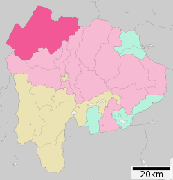 Location of Hokuto in Yamanashi Prefecture | |||
 Hokuto
| |||
| Coordinates: 35°46′35.3″N 138°25′25.1″E / 35.776472°N 138.423639°ECoordinates: 35°46′35.3″N 138°25′25.1″E / 35.776472°N 138.423639°E | |||
| Country | Japan | ||
| Region | Chūbu (Kōshin'etsu) | ||
| Prefecture | Yamanashi Prefecture | ||
| Government | |||
| • - Mayor | Masashi Shirakura (since November 2004) | ||
| Area | |||
| • Total | 602.48 km2 (232.62 sq mi) | ||
| Population (November 1, 2015) | |||
| • Total | 45,362 | ||
| • Density | 75.3/km2 (195/sq mi) | ||
| Time zone | Japan Standard Time (UTC+9) | ||
| City symbols | |||
| • Tree | Japanese red pine | ||
| • Flower | Sunflower | ||
| • Bird | Ural owl | ||
| Phone number | 0551-42-1111 | ||
| Address | 961-1 Daizu-namada, Sutama-chō, Hokuto-shi, Yamanashi-ken 408-0188 | ||
| Website |
www | ||


Hokuto (北杜市 Hokuto-shi) is a city located in Yamanashi Prefecture, Japan.
As of November 2015, the city had an estimated population of 45,362 and a population density of 75.3 persons per km2. The total area was 602.48 square kilometres (232.62 sq mi).
Geography
Hokuto is located in far northwest Yamanashi Prefecture. Most of the area of the city is elevated highland and forested. With a cooler alpine climate in summer, smaller towns such as Kiyosato are a popular location for second homes.
Neighboring municipalities
Climate
| Climate data for Ōizumi(1981-2010) | |||||||||||||
|---|---|---|---|---|---|---|---|---|---|---|---|---|---|
| Month | Jan | Feb | Mar | Apr | May | Jun | Jul | Aug | Sep | Oct | Nov | Dec | Year |
| Average high °C (°F) | 4.5 (40.1) |
5.4 (41.7) |
9.3 (48.7) |
15.7 (60.3) |
20.1 (68.2) |
23.0 (73.4) |
26.6 (79.9) |
28.2 (82.8) |
23.7 (74.7) |
17.9 (64.2) |
12.6 (54.7) |
7.4 (45.3) |
16.2 (61.17) |
| Daily mean °C (°F) | −0.4 (31.3) |
0.2 (32.4) |
3.7 (38.7) |
9.6 (49.3) |
14.3 (57.7) |
18.0 (64.4) |
21.6 (70.9) |
22.6 (72.7) |
18.7 (65.7) |
12.7 (54.9) |
7.3 (45.1) |
2.3 (36.1) |
10.9 (51.6) |
| Average low °C (°F) | −5.2 (22.6) |
−4.8 (23.4) |
−1.5 (29.3) |
3.9 (39) |
9.2 (48.6) |
13.9 (57) |
17.8 (64) |
18.6 (65.5) |
14.7 (58.5) |
8.2 (46.8) |
2.5 (36.5) |
−2.5 (27.5) |
6.23 (43.23) |
| Average precipitation mm (inches) | 39.8 (1.567) |
42.7 (1.681) |
76.6 (3.016) |
80.8 (3.181) |
102.8 (4.047) |
146.4 (5.764) |
153.6 (6.047) |
139.4 (5.488) |
170.0 (6.693) |
113.4 (4.465) |
50.9 (2.004) |
29.6 (1.165) |
1,145.8 (45.11) |
| Source: Japan Meteorological Agency(JMA)[1] | |||||||||||||
History
During the Edo period, all of Kai Province was tenryō territory under direct control of the Tokugawa shogunate. During the cadastral reform of the early Meiji period in April 1, 1889, the rural district of Kitakoma was formed.
The modern city of Hokuto was established on November 1, 2004, from the merger of the towns of Hakushū, Nagasaka, Sutama and Takane, and the villages of Akeno, Mukawa and Ōizumi (all from Kitakoma District). On March 15, 2006, Hokuto absorbed the town of Kobuchisawa (also from Kitakoma District). Kitakoma District was dissolved as a result of this merger.
Economy
The economy of Hokuto is primarily agricultural, with seasonal tourism, precision manufacturing and food processing laying secondary roles.
Education
- Teikyo-Gakuen Junior College
- Hokuto has eight elementary schools, nine middle schools and two high schools.
Transportation
Railway
Highway
Sister cities
 - Fukuroi, Shizuoka – since March 9, 1987 between former Asaba, Shizuoka and former Akeno, Yamanashi
- - Joetsu, Niigata – since January 17, 1991 between former Misaka Town and former Kakizaki, Niigata and Sutama, Yamanashi
- - Hamura, Tokyo – since October 1, 1996 with former Takane Town
- - Nishitokyo, Tokyo since February 4, 1999 between former Tanashi, Tokyo and the former town of Sutama, Yamanashi
 - Madison County, Kentucky, USA[2] – since May 12, 1990 with former municipalities of Takane, Nagasaka, Ōizumi, and Kobuchisawa
- - LeMars, Iowa, USA – since July 3, 1993 with former Sutama Town
 - Pocheon, Gyeonggi-do, South Korea[3] – since March 21, 2003 with former Takane Town
-
 - Manciano, Tuscany, Italy with former Kobuchisawa Town
 -
 - Crowsnest Pass, Alberta (unratified)
Local attractions
- Kiyosato Plateau
- Musée Kiyoharu Shirakaba
References
- ↑ "大泉 1981-2010年". JMC. Retrieved January 7, 2012.
- ↑ "US-Japan Sister Cities by State". Asia Matters for America. Honolulu, HI: East-West Center. Retrieved 20 November 2015.
- ↑ "International Exchange". List of Affiliation Partners within Prefectures. Council of Local Authorities for International Relations (CLAIR). Retrieved 21 November 2015.
External links
![]() Media related to Hokuto, Yamanashi at Wikimedia Commons
Media related to Hokuto, Yamanashi at Wikimedia Commons
- Hokuto City official website (Japanese)
| Special city | ||
|---|---|---|
| Cities | ||
| Kitatsuru District | ||
| Minamikoma District | ||
| Minamitsuru District | ||
| Nakakoma District | ||
| Nishiyatsushiro District | ||