Fujikawa, Yamanashi
| Fujikawa 富士川町 | |||
|---|---|---|---|
| Town | |||
|
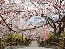
Oboshi Park in Fujikawa Town | |||
| |||
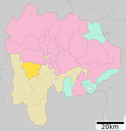 Location of Fujikawa in Yamanashi Prefecture | |||
 Fujikawa
| |||
| Coordinates: 35°33′40″N 138°27′41″E / 35.56111°N 138.46139°ECoordinates: 35°33′40″N 138°27′41″E / 35.56111°N 138.46139°E | |||
| Country | Japan | ||
| Region |
Chūbu Tōkai | ||
| Prefecture | Yamanashi Prefecture | ||
| District | Minamikoma | ||
| Area | |||
| • Total | 111.98 km2 (43.24 sq mi) | ||
| Population (July 1, 2012) | |||
| • Total | 16,009 | ||
| • Density | 143/km2 (370/sq mi) | ||
| Time zone | Japan Standard Time (UTC+9) | ||
| Phone number | 0556-22-1111 | ||
| Address | 1134 Tenjinnakajo Fujkawa-cho Minimikoma-gun, Yamanashi-ken 400-0592 | ||
| Website |
www | ||


Fujikawa (富士川町 Fujikawa-chō) is a town in Minamikoma District, Yamanashi Prefecture, Japan. As of July 2012, the town had an estimated population of 16,009 and a population density of 143 persons per km². The total area was 111.98 km².
Geography
Fujikawa is in the southwestern in Yamanashi Prefecture, bordered by the 2000-meter Kushigatayama to the west, and the Fuji River to the east.
Neighboring municipalities
History
During the Edo period, all of Kai Province was tenryō territory under direct control of the Tokugawa shogunate. During the cadastral reform of the early Meiji period in April 1, 1889, Minamikoma District within Yamanashi Prefecture was created and organized into 22 villages. Kajikazawa village was raised to town status on August 1 1898 and Masuho on April 3, 1951. In 2003, a proposal was raised to merge the towns of Masuho and Kajikazawa with the towns of Ichikawadaimon, Mitama and Rokugō from Nishiyatsushiro District into a new city, or to merge with neighboring Minami-Alps. The proposal was not successful, and instead the three towns in Nishiyatsushiro merged to form Ichikawamisato on October 1, 2005, whereas Masuho and Kajikazawa merged to form Fujikawa on March 8, 2010.
Transportation
Highway
Noted people from Fujikawa
- Kunio Yonenaga – shogi master
- Masaki Fukai – professional football player
- Yu Hasegawa – professional football player
- Yoshifumi Kashiwa – professional football player
External links
![]() Media related to Fujikawa, Yamanashi at Wikimedia Commons
Media related to Fujikawa, Yamanashi at Wikimedia Commons
- Official website (Japanese)
| Special city | ||
|---|---|---|
| Cities | ||
| Kitatsuru District | ||
| Minamikoma District | ||
| Minamitsuru District | ||
| Nakakoma District | ||
| Nishiyatsushiro District | ||